Loading
SCANable
  • Home
  • About Us
    • COVID-19 Response
    • News
  • Services
    • Request 3D Scanning Services
      • Architecture & Heritage
      • Civil/Survey
      • Plant, Process & Marine
      • Security and Threat Analysis
      • Training and Support
    • Mobile Photogrammetry Studios
    • C.A.L.V.I.N.N.™ Camera Array for Lightfields, Volumetrics, Imaging, and Neural Networks
    • Virtual Production Support
    • Drone Photogrammetry
    • Digital Doubles
    • Sets and Environments
    • Props and Products
    • Vehicles
    • Rentals
  • Recent Productions
  • Locations
    • Los Angeles
    • New York
    • Atlanta
    • New Orleans
    • Houston
  • Contact
  • Click to open the search input field Click to open the search input field Search
  • Menu Menu

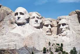
Mount Rushmore to add laser scans, digital mapping in preservation efforts
June 2, 2009/0 Comments/in 3D Laser Scanning, Government/by Travis Reinke

Source: http://www.rapidcityjournal.com/articles/2009/05/23/news/local/doc4a1702bb8841b911374516.txt

Officials at Mount Rushmore National Memorial have added new tools in the constant effort to preserve the national icon.

While crews traditionally use silicone sealant, fracture-mapping techniques and other technology to preserve the faces, they have added laser scanning and digital mapping to tools use to keep the 68 year old in good condition.

Duane Bubac, director of cultural resources and facilities at Mount Rushmore National Memorial, said the mapping project will give the National Park Service detailed information about the features of Mount Rushmore. And the data could later be used to create virtual, up-close tours of Mount Rushmore.

In the past, maintenance was mostly a once-a-year event. Each fall, rope-access crews descended from the top of the memorial to inspect the granite and caulk the surface cracks. The fall maintenance work still takes place every September, Bubac said, but it’s now part of a much larger, year-around effort to monitor and preserve Mount Rushmore National Memorial.

“The process involves a lot more than sealing cracks now,” Bubac said.

Under the National Park Service long-range preservation plan, crews are fracture-mapping and crack-mapping the granite surface. They are also removing vegetation, cleaning and sealing cracks, removing hazard rocks and testing the next generation of sealant materials.

Mount Rushmore’s biggest threat is water. It seeps into cracks, freezes and expands. That freeze-thaw cycle could eventually degrade the surface of the granite. Dirt and vegetation could also be a threat. If dirt can accumulate in a small hollow, it gives opportunist weeds, bushes or trees the foothold they need to take root.
Tags: laser scan, mount rushmore, Point Cloud
Share this entry
  • Share on Facebook
  • Share on X
  • Share on WhatsApp
  • Share on Pinterest
  • Share on LinkedIn
  • Share on Tumblr
  • Share on Vk
  • Share on Reddit
  • Share by Mail
https://scanable.com/wp-content/uploads/2025/01/SCANable_logo_emblemSimple-180x180.png 0 0 Travis Reinke https://scanable.com/wp-content/uploads/2025/01/SCANable_logo_emblemSimple-180x180.png Travis Reinke2009-06-02 10:46:322009-06-02 10:46:32Mount Rushmore to add laser scans, digital mapping in preservation efforts
You might also like
REVIEW:: ClearEdge3D EdgeWise™ – High Definition CAD Models Automatically From Point Clouds
Quantapoint Announces Integration of 3D Laser Scan Data With Autodesk(R) Revit(R)
Leica Geosystems Announces the Release of Leica CloudWorx™ 1.0 for SmartPlant 3D
Leica Cyclone II Topo Leica Cyclone II Topo 2.0 Early Look at New Find Terrain Feature
Autodesk Releases Subscription Advantage Packs with Ambercore Point Cloud Technology
Autodesk Announces Availability of Autodesk Navisworks 2010 with Point Cloud Operability
Exploring Point-Based Rendering in Pixar’s RenderMan [Point Clouds]
UPDATE: GSA Nationwide Laser Scanning Services Contract Awards
0 replies

Leave a Reply

Want to join the discussion?
Feel free to contribute!

Leave a Reply Cancel reply

Your email address will not be published. Required fields are marked *

Pages

  • 2023 Trilith Charity Gala
  • 3D Body Scanning, LiDAR and VFX Support in Houston, Texas
  • 3D Head and Body Scanning
  • 3D Object Scanning
  • 3D Scanning & VFX Capture in Los Angeles
  • 3D Scanning & VFX Capture in Texas | SCANable
  • 3D Scanning, Drone Photogrammetry & LiDAR in Atlanta | SCANable
  • 3D Scanning, Drone Photogrammetry & LiDAR in New York City | SCANable
  • 3D VFX LiDAR Scanning and Support in New Orleans, Louisiana
  • 3D VFX Scanning and Support in Atlanta, Georgia
  • 3D VFX Scanning and Support in Los Angeles, California
  • 3D VFX Scanning and Support in New York
  • About Us
  • Architecture & Heritage
  • Artec Leo
  • Asset
  • Awards
  • Blog
  • C.A.L.V.I.N.N.™ Camera Array for Lightfields, Volumetrics, Imaging, and Neural Networks
  • Cart
  • Checkout
  • Civil/Survey
  • Clients
  • Contact
  • Drone Photogrammetry
  • FARO Focus S 150 and 350 3D Laser Scanner
  • FARO Focus3D X 330 Long Range 3D Laser Scanner
  • FARO Freestyle3D Handheld Scanner
  • Home
  • Industry News
  • Leica HDS6200
  • LiDAR Location and Environment 3D Scanning
  • Logout
  • Maquette, Statues and Fine Art 3D scanning
  • Mobile 3D Scanning
  • Mobile Photogrammetry Studios
  • MoPho 1 Service Request
  • MoPho 2 Service Request
  • MoPho 3 Service Request
  • My Account
  • New
  • News
  • Plant, Process & Marine
  • Pricing and FAQ
  • Privacy Policy
  • Purchase Affordable 3D Laser Scanners
  • Recent Productions
  • Rent the Leica RTC360
  • Request 3D Scanning Services
  • SCANable Rig Checklist
  • SCANable UAS (Unmanned Aerial Systems)
  • SCANable | COVID-19 Response
  • Security and Threat Analysis
  • Services
  • Shop
  • Surphaser 100HSX
  • Trailer Move
  • Training and Support
  • VFX 3D Vehicle Scanning For Film and Television
  • VFX is not AI
  • Virtual Reality
  • Visual Effects/CGI

Categories

  • 3D Laser Scanning
  • 3D Printing
  • Animation
  • Archaeology
  • Blog
  • Building Information Modeling (BIM)
  • Events
  • Featured
  • Forensic
  • Government
  • In the News
  • Industrial
  • Industry
  • LiDAR
  • Mobile Scanning
  • Modeling
  • New Hardware
  • New Technology
  • News
  • Photogrammetry
  • Point Cloud
  • Reviews
  • Software
  • Uncategorized
  • Virtual Reality
  • Visual Effects (VFX)

Archive

  • June 2025
  • May 2025
  • January 2025
  • December 2024
  • November 2022
  • October 2020
  • August 2020
  • July 2020
  • June 2020
  • January 2020
  • July 2017
  • May 2017
  • April 2017
  • December 2016
  • November 2016
  • October 2016
  • September 2016
  • July 2016
  • May 2016
  • March 2016
  • September 2015
  • June 2015
  • May 2015
  • March 2015
  • January 2015
  • December 2014
  • November 2014
  • August 2014
  • June 2014
  • April 2014
  • March 2014
  • February 2014
  • January 2014
  • November 2013
  • June 2013
  • March 2013
  • January 2013
  • December 2012
  • November 2012
  • September 2012
  • August 2012
  • July 2012
  • December 2010
  • November 2010
  • October 2010
  • August 2010
  • May 2010
  • April 2010
  • March 2010
  • February 2010
  • January 2010
  • December 2009
  • November 2009
  • October 2009
  • September 2009
  • August 2009
  • July 2009
  • June 2009
  • May 2009

Quick Pages

  • Home
  • News
  • Services
  • Contact
  • Privacy Policy

Recent Productions

  • Play Dirty (Prime Video)
  • Peacemaker (DC Studios)
  • Marty Supreme (A24)
  • Superman (DC Studios)
  • Happy Gilmore 2 (Netflix)

Categories

  • 3D Laser Scanning
  • 3D Printing
  • Animation
  • Archaeology
  • Blog
  • Building Information Modeling (BIM)
  • Events
  • Featured
  • Forensic
  • Government
  • In the News
  • Industrial
  • Industry
  • LiDAR
  • Mobile Scanning
  • Modeling
  • New Hardware
  • New Technology
  • News
  • Photogrammetry
  • Point Cloud
  • Reviews
  • Software
  • Uncategorized
  • Virtual Reality
  • Visual Effects (VFX)

Locations

Georgia

Los Angeles

New York

Houston

New Orleans

© Copyright 2026 - SCANable - Enfold Theme by Kriesi
  • Link to Facebook
  • Link to X
  • Link to LinkedIn
  • Link to Youtube
  • Link to Rss this site
  • Link to Instagram
Link to: NASA Uses Laser Scan Data and Photosynth to Evaluate Shuttle Damage Link to: NASA Uses Laser Scan Data and Photosynth to Evaluate Shuttle Damage NASA Uses Laser Scan Data and Photosynth to Evaluate Shuttle Damage Link to: Hexagon Metrology Launches PC-DMIS Reshaper Link to: Hexagon Metrology Launches PC-DMIS Reshaper Hexagon Metrology Launches PC-DMIS Reshaper
Scroll to top Scroll to top Scroll to top