R3dS Wrap Topology Transfer Software

Introducing R3DS Wrap – Topology Transfer Tool

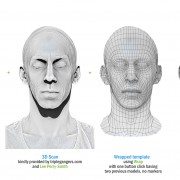
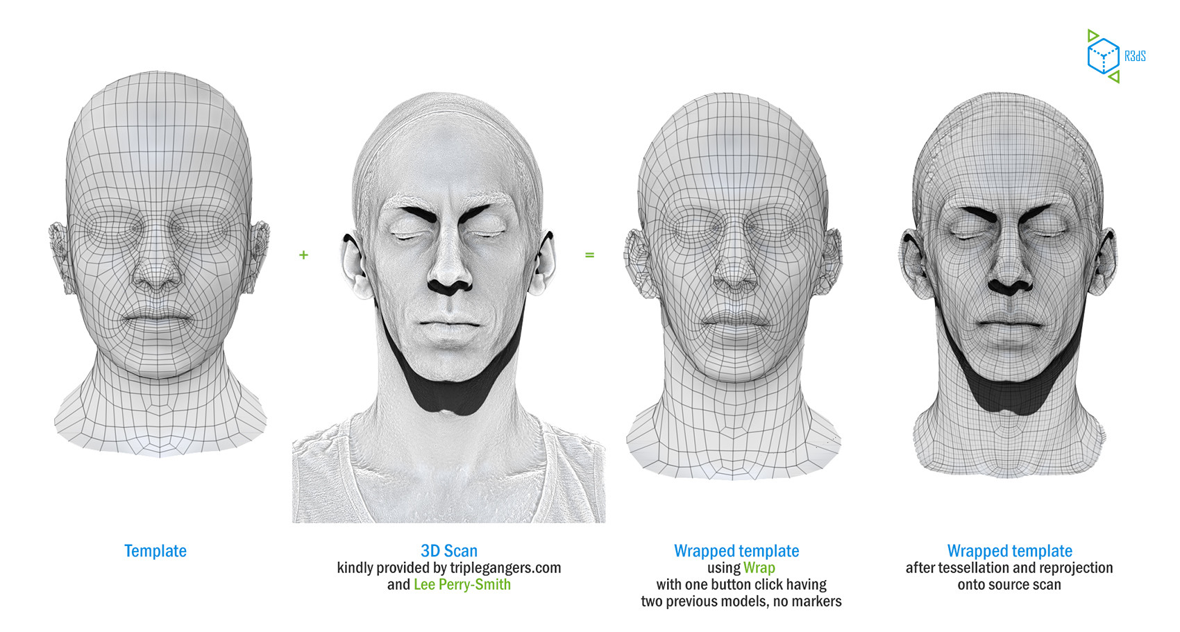
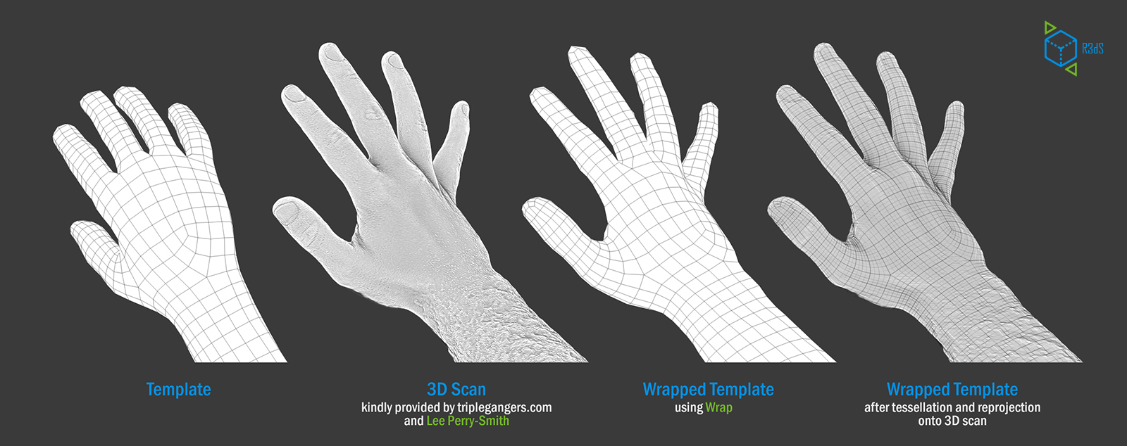
Wrap is a topology transfer tool. It allows to utilize the topology you already have and transfer your new 3D-scanned data onto it. The resulting models will not only share the same topology and UV-coordinates but also will naturally become blendshapes of each other. Here’s a short video how it works:

and here are a couple of examples based on 3D-scans kindly provided by Lee Perry-Smith

R3dS Wrap Topology Transfer Software

You can download a demo-version from their website http://www.russian3dscanner.com

As with all new technology during its final beta stages, Wrap is not perfect yet. R3DS would be highly appreciative and grateful of everyone that gives us the support and feedback to finalize things in the best possible way. This software has some potential to be a great tool. Check it out!

Autodesk ReCap: Making Reality Capture Easy and Affordable

Autodesk Aims to Streamline Use of Point Cloud Data

A key addition to the complete 2014 portfolio of Suites is Autodesk® ReCap™ product, a family of powerful and easy-to-use software and services on the desktop and in the cloud to create intelligent 3D data from captured photos and laser scans in a streamlined workflow.  Autodesk ReCap is the first industry solution to bring together laser scanning and photogrammetry into one streamlined process. In addition, no other solution on the market provides the visualization quality and scalability to handle extremely large data sets.

The Autodesk ReCap product line comprises two main offerings – Autodesk ReCap Studio and Autodesk ReCap Photo. Autodesk ReCap Studio makes it easy to clean, organize and visualize massive datasets captured from reality. Autodesk ReCap Photo helps users create high-resolution textured 3D models from photos using the power of cloud computing. Rather than beginning with a blank screen, Autodesk ReCap now enables any designer, architect or engineer to add, modify, validate and document their design process in context from existing environments.

For example, a civil engineer can bypass an existing bridge or expand the road underneath digitally and test feasibility. At construction phase, builders can run clash detection to understand if utilities will be in the way. Urban planners can get answers to specific design questions about large areas, such as how much building roof surface is covered by shadow or vegetation.

ReCap Studio is a data preparation environment that runs on the desktop.  Users can import captured data directly into Autodesk design solutions, such as AutoCAD®, Autodesk® Revit®, Autodesk Inventor®, etc., to conduct QA and verification of data. The data can come from non-intelligent, black and white sparse point clouds to intelligent, visually high appealing content. ReCap Studio will ship in Autodesk product and suite installers or be available for free on the Autodesk Exchange Apps store.

ReCap Studio 2

ReCap Photo is an Autodesk 360 service designed to create high resolution 3D data from photos to enable users to visualize and share 3D data. By leveraging the power of the cloud to process and store massive data files, users can upload images on Autodesk 360 and instantly create a 3D mesh model. ReCap Photo is available with Standard Suites entitlement and higher.

ReCap Photo 2

Key features of Autodesk ReCap include:

  • Visualize and edit massive datasets:  On the desktop, ReCap users can view and edit billions of points to prepare them for use in Autodesk portfolio products to enable realistic in context design work
  • Professional-Grade Photo to 3D Features: ReCap unlocks the power of ubiquitous cameras to capture high-quality 3D models, bringing reality capture within reach of anyone with a camera.  ReCap supports objects of any size and range, full resolution for high-density meshes, survey points and multiple file exports.
  • Photo and Laser: ReCap incorporates the best of both photo and laser data capture so that customers can use photos to fill in holes or augment laser scan data. Users can both increase photos scene accuracy with laser points and add photo-realistic detail to laser scans. Create point clouds from photos, align scans and photos and convert professional grade photo to 3D models.

Autodesk continues to invest in developing sophisticated, easy-to-use reality capture technologies. The company has made several key acquisitions including Alice Labs and Allpoint Systems as well as applied its own research and development resources to accelerate the mainstream adoption of these technologies. As customers are looking for ways to easily and accurately capture the world around them, Autodesk ReCap streamlines Reality Capture workflows, making working with Reality Capture data easyquick and cost effective.

Autodesk is the only company who has combined laser scanning data and photogrammetry into one product family to address and streamline the entire workflow.  Whereas traditional point clouds appear as dots, Autodesk technology can now visualize truly massive point clouds as realistic surfaces. Unique to Autodesk is that users can interact with these huge data sets doing CAD-like operations such as selection, tagging, moving, measuring, clash detection, and object extraction, all with native points. Laser scanning and photogrammetry are historically very expensive and data intensive. Autodesk’s goal is to democratize the process of reality capture so that anyone can capture the world around them to create high quality 3D models.

Leica Geosystems Cyclone

Leica Geosystems Announces Major Advances in Cyclone 8.0 Software

Leica Geosystems Announces Cyclone 8.0 Software – Major Advances for “Point Cloud” Office Productivity, Spatial Data Connectivity, and Customization

(Heerbrugg/Switzerland and Hanover/Germany, 9 October 2012) – Leica Geosystems announces the next major release of its flagship software, Leica Cyclone 8.0. In addition to providing further improvements in office productivity for processing as-built laser scan data, Cyclone 8.0 gives users powerful, new capabilities. Users can now directly connect point cloud data with other spatial data sources (such as 3D models) and readily share and re-use modeled data. Leica Cyclone 8.0 is being introduced at Intergeo as supporting software for the new Leica ScanStation P20 ultra-high speed laser scanner.

Office Productivity Gains

Cyclone 8.0 features several enhancements that increase office productivity, often significantly:

[listdot]

  • 20 – 50% faster scan data import
  • Automatic conversion on import to Enhanced Working Format, for faster data processing
  • Automatic creation of all pipe cylinders, with a single click, for an entire project or for a selected set of scan data, even during import
  • Automatic creation of TruView Hotlinks, linking scan points in panoramic TruViews to asset information
  • Easy saving and re-use of complex models created from geometric primitives
  • New “scripting” capability speeds repetitive or customized sequences of model building
  • Fewer clicks and a modern CAD-like interface for popular “Move” and “Rotate” commands[/listdot]

Read more

ClearEdge3D Valve-flange

ClearEdge3D Releases EdgeWise Plant™ 4.0


Now offers full, end-to-end 3D modeling solution with 9 new features and enhancements including valve/flange placement, demolition tool, custom spec editor, high-definition visualization and more


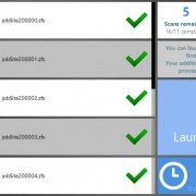
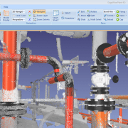
Herndon, Virginia — December 12, 2012 — ClearEdge3D today released EdgeWise Plant™ 4.0, with 9 major new features and enhancements that create the fastest end-to-end pipe modeling solution on the market. The software automates the 3D modeling of complex process plant facilities, cutting up to 85% of labor from the modeling workflow.

Robert Greenhalgh with Ramboll Oil & Gas used the software on a recent North Sea offshore project. “We reduced our 3D modeling time substantially with EdgeWise Plant 4.0,” said Greenhalgh. ”Building standard pipe fittings on top of the powerful automated tools makes 4.0 the complete pipe modeling package.”

Read more

ClearEdge3D Launches EdgeWise MEP for Autodesk Revit


Automated Feature Extraction of pipes from point clouds now available for Revit—promises substantial workflow savings of up to 85%

Herndon, Virginia — September 5, 2012 — ClearEdge3D announced today the release of its latest product, EdgeWise MEP™ for Autodesk® Revit®. For the first time, users can bring extracted pipes, conduit and other cylindrical mechanical, electrical, and plumbing (MEP) elements directly into Revit. ClearEdge3D’s new MEP solution leverages the powerful feature extraction technology of EdgeWise to automatically extract pipe solids from laser scan point clouds.  These pipe solids can be automatically connected into pipe runs, annotated within EdgeWise MEP, and then brought directly into Revit as fully functional Revit pipe objects. All intelligence extracted by EdgeWise, such as diameter, length, elbow bend radius and more, is also transferred into Revit.


Beta testers of EdgeWise MEP for Revit reported modeling time savings of up to 85 percent over their previous workflows. “EdgeWise MEP for Revit greatly enhances the field-to-finish workflow.  It’s the innovation our BIM customers have been asking for,” said Chris Scotton, ClearEdge3D’s President and CEO. “Now users can combine the speed of EdgeWise Automated Feature Extraction with the power of Revit to produce Revit deliverables much faster than ever before.”


Working closely with the Autodesk Revit MEP product management team and a group of highly experienced Revit users, ClearEdge3D developed EdgeWise MEP for Revit to dramatically speed the process of modeling MEP as-builts.  “Modeling MEP for BIM has traditionally been a very tedious process,” Scotton continued. “EdgeWise MEP for Revittakes much of the manual modeling out of the workflow and instantly delivers the data straight into Revit as pipe objects, thus reducing  a project’s cost and schedule.  While the current release focuses on cylinder extraction, future releases will be able to automatically extract square ducting, cable trays and other planar objects.”Kelly Cone, Innovations Director at Beck Architecture, recently tested the beta release.  “Edgewise MEP for Revit is a huge step forward in our market. Tasks that used to take us days to complete can now be done in a few hours.” Another beta tester, Devon Kelley at Precision Point, Inc. recently completed a hospital MEP project using the new software. “I am beyond impressed.  I was able to simply highlight all the pipe objects and click the “convert to pipes” button. Revit automatically recognized the pipe size which was incredible. So far it has exceeded my expectations. “


To request a live demonstration of EdgeWise MEP for Revit click here: www.clearedge3d.com.


About ClearEdge3D

ClearEdge3D was founded in 2006 by two recognized experts and thought-leaders in the field of computer vision, Automated Feature Extraction, and LIDAR data analysis.  The company’s flagship products, EdgeWise Plant™, EdgeWise MEP™ for Revit and EdgeWise Building™, are used by top engineering firms world-wide to optimize their scan-to-model workflow. The company is privately-held and headquartered in Herndon, Virginia.


Autodesk and Revit are registered trademarks or trademarks of Autodesk, Inc., in the USA and other countries.

-###-


For more information, contact:

Janice Starrs

janice.starrs@clearedge3d.com

USA +1 410-991-0582

INOVx RealityLINx

INOVx Announces Release of RealityLINx 5.4 and Leica HDS pcE Support

Tuesday November 30, 2010 – INOVx Solutions, the leader in virtual asset solutions for plants, announces the release of version 5.4 of its RealityLINx® Asset Virtualization® platform. RealityLINx 5.4 includes a number of performance, functional, and usability enhancements. The new release features an entirely new underlying database engine, providing for significantly faster queries of the virtual plant model and associated data. The new RealityLINx release is also now available in a 64-bit version, taking advantage of the superior processing capability of Windows 64 bit architectures. Users will also discover a number of functional and usability improvements in the 5.4 release including private Knowledge Views, customizable tool tips, additional templates, new macro features, and new options for marked points.

A New Milestone in the Leica Geosystems HDS / INOVx Partnership
This latest release of RealityLINx, also breaks ground as the first offering from a partnership with Leica Geosystems HDS to jointly develop and distribute advanced software for converting laser scan data into intelligent plant models. Through this partnership with Leica Geosystems, the RealityLINx platform now incorporates the powerful point cloud engine (pcE) from Leica Cyclone. This combination of Leica and INOVx technologies found in RealityLINx 5.4 enables the transformation of laser scans of as-built assets into highly accurate geometries and intelligent asset models, faster than ever before possible. The Leica Geosystems / INOVx collaboration is grounded in an open solutions approach that can be deployed regardless of the specific type of laser scanner used or plant design software involved. The RealityLINx family of CAD adapters has also been expanded to support the import and synchronization of Leica Cyclone (COE) models into RealityLINx intelligent asset models.

Customers that rely on RealityLINx for creating plant models from laser scans will realize a number of benefits with the 5.4 release, including:

  • enhancements in assisted, rapid modeling of steel structural elements
  • display scan points for >10x as many scanner positions
  • speed up display times by >25x for regions of point clouds that include multiple scanner positions
  • quickly “clip” or remove undesired scan points near objects of interest, even with >40 regions displayed
  • eliminate time consuming scan data format conversion and import/export steps
  • display true color point clouds that look exactly like the real plant object

Finally, this release of RealityLINx also marks an expanded business agreement between Leica Geosystems and INOVx, establishing Leica Geosystems HDS the sole distribution channel for the RealityLINx Model product. Leica Geosystems will also offer, via their global distribution channels, the RealityLINx View and RealityLINx Manage products.

Industry Embracing the Benefits of Plant Models from Laser Scans
The use of 3D laser scanning to capture as-built geometry of plants has grown rapidly. This technology is driving improvements in the accuracy and completeness of Asset Documentation, providing customers with a foundation for better safety and environmental compliance. In addition, industry is increasingly taking advantage of intelligent 3D models developed from laser scans of facilities in order to drive new efficiencies in work processes ranging from design and construction through operations and maintenance. This new Asset Virtualization approach is transforming the way plant assets are managed, across the industry. By enabling the rapid construction of highly accurate models from laser scans, the RealityLINx platform accelerates activities in both Asset Documentation and Asset Virtualization solutions.

“We are pleased to already be delivering on the partnership we announced earlier this year with Leica Geosystems. Over the coming months and years, our combined technologies and efforts in providing tools for the rapid modeling of plant assets will set the standard for the process industries and benefit customers of both Leica and INOVx. Improvements in the creation of intelligent models from laser scans of as-built facilities further accelerates deployment of INOVx’s Asset Virtualization solutions by making these solutions faster, more cost effective, more functional and easier to maintain,” says Costantino Lanza, CEO of INOVx.

“Leica Geosystems is very excited to take this next, important step with INOVx. The new product, RealityLINx 5.4, is not only a great example of the significant productivity advantages of Leica point cloud Engine (pcE) technology in third party point cloud software, but our expanded partnership also provides customers with an even more complete laser scanning product solution offering from Leica Geosystems for the plant market,“ states Juergen Dold, CEO, Leica Geosystems.

About INOVx
INOVx, founded in 1999, provides a platform and solutions for Asset Virtualization® to companies in the process industries worldwide. INOVx’s RealityLINx product enables the creation, management and access to high fidelity three dimensional views of plant assets. These views are used in daily work practices to better communicate and navigate all asset information. INOVx solutions support many plant functions such as reliability, safety, operations, maintenance, inspection, and engineering. INOVx is a pioneer and thought leader in the application of laser scanning technology for the creation of accurate and precise three dimensional models of existing facilities. This Asset Documentation Service offers a reliable and proven way of creating and maintaining the three dimension asset models. INOVx is headquartered in Irvine, California. For more information please visit www.inovx.com..

Leica Geosystems – when it has to be right
With close to 200 years of pioneering solutions to measure the world, Leica Geosystems products and services are trusted by professionals worldwide to help them capture, analyze, and present spatial information. Leica Geosystems is best known for its broad array of products that capture accurately, model quickly, analyze easily, and visualize and present spatial information.

Those who use Leica Geosystems products every day trust them for their dependability, the value they deliver, and the superior customer support. Based in Heerbrugg, Switzerland, Leica Geosystems is a global company with tens of thousands of customers supported by more than 3’500 employees in 28 countries and hundreds of partners located in more than 120 countries around the world. Leica Geosystems is part of the Hexagon Group, Sweden.

Pointools

Pointools introduces Point Cloud plug-in for Google SketchUp

Source: Pointools Blog:

Pointools has unveiled a Plug-in for Google SketchUp in time for the European LiDAR Mapping Forum, Autodesk University and SPAR Europe. The new Pointools Plug-in for SketchUp streamlines scan-to-model workflows for all SketchUp and SketchUp Pro users by enabling reuse of the largest point cloud models, and by providing a first-of-a-kind solution to create 3D city models from mobile scan data.

Like the Pointools Plug-ins for Rhino and AutoCAD applications, the Pointools plug-in for SketchUp eliminates the need for time-wasting translations, maintains visual quality and accuracy of point cloud models in SketchUp, and increases modeling productivity by reading the Pointools POD model file format to display billions of points on screen.

“This is great news for Google SketchUp and SketchUp Pro users,” commented Joe Croser, VP Products at Pointools. “The Pointools plug-in for SketchUp has been designed from the ground-up to take full advantage of SketchUp’s modelling environment and supports Google’s geo-location services to coordinate StreetView textures and aerial imagery alongside point clouds.”

The Pointools Plug-in for SketchUp extends Pointools’ leadership as an enabler for reusing the largest point cloud models inside the broadest range of applications. Croser continued, “Through our Vortex platform and widely-used software plug-ins, thousands of Autodesk, Bentley, and Rhino users have been able to benefit from streamlined point cloud model reuse across different applications by eliminating time-wasting translations. Now, the Pointools Plug-in for SketchUp, enables the same users to increase their return on investment (ROI) from 3D laser scan data by also reusing the same point cloud models inside SketchUp.”

Google SketchUp is a modelling programme originally designed for architectural, civil and mechanical engineers as well as filmmakers, game designers and other design professionals. With both Professional and Freeware versions, SketchUp is easy and intuitive to use – allowing design professionals to draw the way they want by emulating the feel and freedom of working with pen and paper.

Quantapoint Announces Integration of 3D Laser Scan Data With Autodesk(R) Revit(R)

PITTSBURGH, PA — (Marketwire) — 10/29/09 — Quantapoint (http://www.quantapoint.com) — recent recipient of a General Services Administration (GSA) laser scanning IDIQ contract — announced the integration of Quantapoint 3D laser scan data with Autodesk® Revit using QuantaCAD(TM). Laser data may be accessed directly within Revit as photo-realistic Laser Images(TM) of individual 3D laser scans and high-definition Laser Models(TM) of integrated laser data, not fuzzy “point clouds” whose sparse measurements make them difficult to use and understand.

“One of the challenges of Building Information Modeling (BIM) has been creating 3D BIM models that accurately represent existing buildings,” said Eric Hoffman, Founder of Quantapoint. “By integrating Laser Models and Laser Images with Revit, Quantapoint can more quickly create 3D BIM models and validate their accuracy. Additionally, new 3D BIM designs can be viewed and clashed with the laser data to ensure that they will fit into the existing facility, thus eliminating rework.”

QuantaCAD provides a number of useful capabilities to Revit users to enable them to create and validate 3D BIM models, visualize proposed modifications for design and constructability reviews, and identify and correct potential interferences. Some of the capabilities include:

  • Direct Integration: Integrate laser data with Revit directly, without sub-sampling or converting to “polygon meshes.”
  • Laser Models: Display 3D BIM models using solid, high-definition
  • Laser Models for direct remodeling or to create new designs.
  • Laser Image Projection: Project 3D BIM models into Laser Images of individual 3D laser scans for real-time validation or design reviews.
  • Measurement: Measure points, distances and mechanical or plumbing pipe information between the 3D BIM model, Laser Images and Laser Models.
  • Clashing: Clash laser data and 3D BIM models to verify remodeling accuracy or identify interferences with new designs.
  • Demolition: Group Laser Models that are parts of the facility being demolished and highlight or hide them for planning or design analysis.
  • Multi-user Database: Share measurements across the team via a multi- user database to ensure consistent information and easier interactions.
  • State Manager: Store and recall laser data (Laser Models, Laser
  • Images and views) to focus on areas or interest and more quickly resume work.

By using QuantaCAD to put reality in Revit, BIM remodeling time can be reduced while ensuring accuracy, design time can be decreased by accessing complete and clear Laser Models and Laser Images that represent existing conditions, and rework from design clashes can be eliminated by correcting clashes between the Laser Models and the new design.

If you are interested in finding out more about accessing laser data in Revit using QuantaCAD or would like a demonstration, visitwww.quantapoint.com/qp/contact or e-mail info@quantapoint.com.

About Quantapoint

Quantapoint uses patented laser scanning technology to create a high-resolution Digitized Facility(TM) of Laser Models(TM) (not “point clouds”) and Laser Images(TM) that can be accessed directlywithin various CAD packages or integrated with facility and asset information. By putting critical facility as-built information at our client’s fingertips, Quantapoint has helped them reduce costs, optimize schedules, increase quality and improve safety. For more information on our technology and services, please visit www.quantapoint.com, e-mail info@quantapoint.com or call +1-412-653-0100.

Image Available: http://www2.marketwire.com/mw/frame_mw?attachid=1101374

Add to Digg Bookmark with del.icio.us Add to Newsvine

For additional information, please contact:

James McGill
VP of Marketing
Quantapoint, Inc.
Telephone: 412-653-0100, x-200
E-mail: jmcgill@quantapoint.com

REVIEW: Leica Geosystems ScanStation C10 and Cyclone 7

On Sepember 1, 2009, Leica Geosystems and Point of Beginning Magazine hosted a webinar titled The Business of Laser Scanning — hype or competitive advantage? Presenters Michael Harvey and Frank Hahnel along with Kristi Grahl discussed using laser scanning technology to:

  • Submit more competitive bids — and win more jobs — for both high-end projects and routine surveys.
  • Meet the requirements of customers who increasingly incorporate HDS into their project specifications.
  • Lower your labor costs and increase profit margins on every job.
  • Increase customer satisfaction with more accurate and detailed surveying reports.

During the webinar, the presenters also announced the availability of Leica’s new ScanStation C10 self-contained time-of-flight 3D laser scanner along with Cyclone 7, Cloudworx for SmartPlant3D and Forensic Map.

Some of the benefits of the new ScanStation C10:

  • No cables
  • On-board data storage
  • USB Interface for data transfer
  • Uses Internal Lithium-Ion TPS Total Station Batteries
    • Hot-swappable
    • 3.5 – 4 hours per battery
    • 4 come with scanner
  • GPS antenna and prism mount attachements
  • Automatically switches between oscillate/spin mirror mode to improve speed
  • Can still be used with a laptop
  • 180-degree sweep – scans both sides
  • Higher resolution capability
  • Integrated color touch-screen
  • Light-weight – 28.6 lbs (scanner),
  • More Portable – 62 lbs (scanner in case)
  • Dual High-resolution camera/video with auto exposure and auto focus
    • Faster target acquisition by point and shoot using the on-board color touch screen
    • Acquire full dome images in 4-7 minutes
  • Man Machine Interface (MMI)
    • Similar to Leica TPS Total Stations
  • Shorter Start-up time
  • Low scan power
  • Withstands moisture better than ScanStation 2

Cyclone 7 Features:

  • Updated Traverse Editor
  • Improved meshing capabilities
    • Leica acquired 3Dreshaper – new meshing functionality
    • Meshing of tunnels
  • Point Cloud engine is real-time indexed – faster viewing performance

View this webcast on-demand. The archive will be available for one year from the live broadcast.

Request your FREE on-site demo — Want to see the new ScanStation c10 in action? Reserve your spot at www.leica-geosystems.us/c10.