Loading
SCANable
  • Home
  • About Us
    • COVID-19 Response
    • News
  • Services
    • Request 3D Scanning Services
      • Architecture & Heritage
      • Civil/Survey
      • Plant, Process & Marine
      • Security and Threat Analysis
      • Training and Support
    • Mobile Photogrammetry Studios
    • C.A.L.V.I.N.N.™ Camera Array for Lightfields, Volumetrics, Imaging, and Neural Networks
    • Virtual Production Support
    • Drone Photogrammetry
    • Digital Doubles
    • Sets and Environments
    • Props and Products
    • Vehicles
    • Rentals
  • Recent Productions
  • Locations
    • Los Angeles
    • New York
    • Atlanta
    • New Orleans
    • Houston
  • Contact
  • Click to open the search input field Click to open the search input field Search
  • Menu Menu

Exploring Point-Based Rendering in Pixar’s RenderMan [Point Clouds]

April 15, 2010/0 Comments/in Animation, Featured, Point Cloud/by Travis Reinke

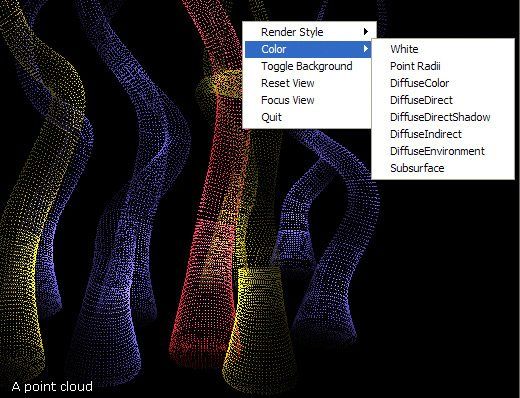
Creating animations of large point cloud datasets generated from terrestrial laser scanners and LiDAR has been an issue for a number of years. While it has been possible using tools such as Leica Geosystems Cyclone or Pointools, just to name a couple, it is still a very cumbersome task. It is exciting to see the CGI industry beginning to adopt the use of this data and developing applications that make it easier to visualize.

Over the last few years, a brand new technology has emerged for creating CGI effects that has already made a big impact on feature film production. It is called point-based rendering, and this powerful technique makes creating global illumination effects for feature film far more practical and efficient than before. In fact, this year the Academy of Motion Picture Art and Sciences awarded the creators of this innovation, Per Christensen, Michael Bunnell and Christophe Hery, with a Scientific and Engineering Academy award.

In this great article written by Nils O Sandys at CGSociety, we will look into the development of this important new technology, how point-based rendering works, and what this all means to the future of feature film production as we know it. Read the full article here.

Tags: laser scan, LiDAR, pixar, point clouds, renderman
Share this entry
  • Share on Facebook
  • Share on X
  • Share on WhatsApp
  • Share on Pinterest
  • Share on LinkedIn
  • Share on Tumblr
  • Share on Vk
  • Share on Reddit
  • Share by Mail
https://scanable.com/wp-content/uploads/2010/04/pc-renderman.jpg 398 520 Travis Reinke https://scanable.com/wp-content/uploads/2025/01/SCANable_logo_emblemSimple-180x180.png Travis Reinke2010-04-15 10:57:172010-04-15 10:57:17Exploring Point-Based Rendering in Pixar’s RenderMan [Point Clouds]
You might also like
Autodesk Announces Availability of Autodesk Navisworks 2010 with Point Cloud Operability
Leica HDS worldwide user conference Leica Geosystems 2010 HDS Worldwide User Conference – Day 1
Daredevil: Born Again: the art and craft of critical VFX collaboration
Baker Purchases Optech Lynx Mobile LiDAR Mapping Solution
Welcome to SCANable, The Ultimate Resource for 3D Laser Scanning and LiDAR
Autodesk Releases Subscription Advantage Packs with Ambercore Point Cloud Technology
NIST’s LIDAR May Offer Peerless Precision in Remote Measurements
Digitally Preserving American History
0 replies

Leave a Reply

Want to join the discussion?
Feel free to contribute!

Leave a Reply Cancel reply

Your email address will not be published. Required fields are marked *

Pages

  • 2023 Trilith Charity Gala
  • 3D Body Scanning, LiDAR and VFX Support in Houston, Texas
  • 3D Head and Body Scanning
  • 3D Object Scanning
  • 3D Scanning & VFX Capture in Los Angeles
  • 3D Scanning & VFX Capture in Texas | SCANable
  • 3D Scanning, Drone Photogrammetry & LiDAR in Atlanta | SCANable
  • 3D Scanning, Drone Photogrammetry & LiDAR in New York City | SCANable
  • 3D VFX LiDAR Scanning and Support in New Orleans, Louisiana
  • 3D VFX Scanning and Support in Atlanta, Georgia
  • 3D VFX Scanning and Support in Los Angeles, California
  • 3D VFX Scanning and Support in New York
  • About Us
  • Architecture & Heritage
  • Artec Leo
  • Asset
  • Awards
  • Blog
  • C.A.L.V.I.N.N.™ Camera Array for Lightfields, Volumetrics, Imaging, and Neural Networks
  • Cart
  • Checkout
  • Civil/Survey
  • Clients
  • Contact
  • Drone Photogrammetry
  • FARO Focus S 150 and 350 3D Laser Scanner
  • FARO Focus3D X 330 Long Range 3D Laser Scanner
  • FARO Freestyle3D Handheld Scanner
  • Home
  • Industry News
  • Leica HDS6200
  • LiDAR Location and Environment 3D Scanning
  • Logout
  • Maquette, Statues and Fine Art 3D scanning
  • Mobile 3D Scanning
  • Mobile Photogrammetry Studios
  • MoPho 1 Service Request
  • MoPho 2 Service Request
  • MoPho 3 Service Request
  • My Account
  • New
  • News
  • Plant, Process & Marine
  • Pricing and FAQ
  • Privacy Policy
  • Purchase Affordable 3D Laser Scanners
  • Recent Productions
  • Rent the Leica RTC360
  • Request 3D Scanning Services
  • SCANable Rig Checklist
  • SCANable UAS (Unmanned Aerial Systems)
  • SCANable | COVID-19 Response
  • Security and Threat Analysis
  • Services
  • Shop
  • Surphaser 100HSX
  • Trailer Move
  • Training and Support
  • VFX 3D Vehicle Scanning For Film and Television
  • VFX is not AI
  • Virtual Reality
  • Visual Effects/CGI

Categories

  • 3D Laser Scanning
  • 3D Printing
  • Animation
  • Archaeology
  • Blog
  • Building Information Modeling (BIM)
  • Events
  • Featured
  • Forensic
  • Government
  • In the News
  • Industrial
  • Industry
  • LiDAR
  • Mobile Scanning
  • Modeling
  • New Hardware
  • New Technology
  • News
  • Photogrammetry
  • Point Cloud
  • Reviews
  • Software
  • Uncategorized
  • Virtual Reality
  • Visual Effects (VFX)

Archive

  • June 2025
  • May 2025
  • January 2025
  • December 2024
  • November 2022
  • October 2020
  • August 2020
  • July 2020
  • June 2020
  • January 2020
  • July 2017
  • May 2017
  • April 2017
  • December 2016
  • November 2016
  • October 2016
  • September 2016
  • July 2016
  • May 2016
  • March 2016
  • September 2015
  • June 2015
  • May 2015
  • March 2015
  • January 2015
  • December 2014
  • November 2014
  • August 2014
  • June 2014
  • April 2014
  • March 2014
  • February 2014
  • January 2014
  • November 2013
  • June 2013
  • March 2013
  • January 2013
  • December 2012
  • November 2012
  • September 2012
  • August 2012
  • July 2012
  • December 2010
  • November 2010
  • October 2010
  • August 2010
  • May 2010
  • April 2010
  • March 2010
  • February 2010
  • January 2010
  • December 2009
  • November 2009
  • October 2009
  • September 2009
  • August 2009
  • July 2009
  • June 2009
  • May 2009

Quick Pages

  • Home
  • News
  • Services
  • Contact
  • Privacy Policy

Recent Productions

  • Play Dirty (Prime Video)
  • Peacemaker (DC Studios)
  • Marty Supreme (A24)
  • Superman (DC Studios)
  • Happy Gilmore 2 (Netflix)

Categories

  • 3D Laser Scanning
  • 3D Printing
  • Animation
  • Archaeology
  • Blog
  • Building Information Modeling (BIM)
  • Events
  • Featured
  • Forensic
  • Government
  • In the News
  • Industrial
  • Industry
  • LiDAR
  • Mobile Scanning
  • Modeling
  • New Hardware
  • New Technology
  • News
  • Photogrammetry
  • Point Cloud
  • Reviews
  • Software
  • Uncategorized
  • Virtual Reality
  • Visual Effects (VFX)

Locations

Georgia

Los Angeles

New York

Houston

New Orleans

© Copyright 2026 - SCANable - Enfold Theme by Kriesi
  • Link to Facebook
  • Link to X
  • Link to LinkedIn
  • Link to Youtube
  • Link to Rss this site
  • Link to Instagram
Link to: National Center for Airborne Laser Mapping Comes to Houston [LiDAR] Link to: National Center for Airborne Laser Mapping Comes to Houston [LiDAR] National Center for Airborne Laser Mapping Comes to Houston [LiDAR] Link to: Tiltan TLiD Transform LiDAR Point Clouds to 3D Models in One Keystroke Link to: Tiltan TLiD Transform LiDAR Point Clouds to 3D Models in One Keystroke Tiltan TLiD Transform LiDAR Point Clouds to 3D Models in One Keystroke
Scroll to top Scroll to top Scroll to top