
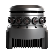

Las Vegas, November 16th, 2016, Leica Geosystems announced the BLK360, a revolutionary miniaturized black 3D imaging laser scanner. The product was revealed at Autodesk University 2016 and will be bundled with Autodesk’s ReCap 360 Pro and the new ReCap 360 Pro app for iPad. Both companies will demonstrate the product for the duration of the conference at the ReCap booth #2033 and the Leica Geosystems booth #1537.
The BLK360 captures the world around you with full-color panoramic images overlaid on a high accuracy point cloud. The one-button Leica BLK360 is not only the smallest and lightest of its kind, but also offers a simple user experience. Anyone who can operate an iPad can now capture the world around them with high resolution 3D panoramic images.
The Leica BLK360 defines a new category: the imaging laser scanner. It is so small and light that it fits in a typical messenger bag and can be carried almost anywhere. It features a 60 meter measurement range for full dome scans. A complete full-dome laser scan, 3D panoramic image capture and transfer to the iPad Pro takes only 3 minutes.
 Using the ReCap Pro 360 mobile app, the BLK360 streams image and point cloud data to iPad. The app filters and registers scan data in real-time. After capture, ReCap 360 Pro enables for point cloud data transfer to a number of CAD, BIM, VR and AR applications. The integration of BLK360 and Autodesk software will dramatically streamline the reality capture process thereby opening this technology to non-surveying individuals.
“When Autodesk first introduced ReCap, it was for one purpose: the democratization of reality capture,” said Aaron Morris, who oversees reality solutions at Autodesk. “We saw the tremendous power of this technology for the AEC industry, but realized that the cost and portability of scanners combined with difficult-to-use data was limiting the adoption of reality capture. Autodesk’s collaboration with Leica Geosystems helps solve these issues by giving just about anyone access to the amazing advantages of reality data.”
“As the leader in the spatial measurement arena, we recognized the gap between Leica Geosystems’ scientific-grade 3D laser scanners and emerging camera and handheld technologies, and set out to bring reality capture to everyone,” said Dr. Burkhard Boeckem, CTO of Hexagon Geosystems. “By combining and miniaturizing technologies available within Hexagon, the BLK360 defines a new category: the Imaging Laser Scanner. It is significantly smaller and lighter (1 kg) than any comparable device on the market. As we developed the ultimate sensor, we worked with Autodesk to create new software and ultimately achieved the next milestone in 3D reality capture. Together with Autodesk’s ReCap 360 Pro, the Leica BLK360 empowers every AEC professional to realize the benefits gained by incorporating high resolution 360° imagery and 3D laser scan data in their daily work.”
BLK360 & Autodesk ReCap 360 Pro Bundle will be available to order in March 2017. The anticipated bundle suggested retail price is $15,990/€15,000, which includes: BLK360 Scanner, Case, Battery, Charger and an annual subscription to ReCap 360 Pro. For customers who want to secure their spot in line to receive the first batch of BLK360 laser scanners, Autodesk and Leica Geosystems are offering a special limited promotion for a discounted three-year ReCap 360 Pro subscription with a voucher giving priority access to buy the BLK360. Go to this link to learn more.
Leica Geosystems – when it has to be right
Revolutionizing the world of measurement and survey for nearly 200 years, Leica Geosystems creates complete solutions for professionals across the planet. Known for premium products and innovative solution development, professionals in a diverse mix of industries, such as aerospace and defense, safety and security, construction, and manufacturing, trust Leica Geosystems for all their geospatial needs. With precise and accurate instruments, sophisticated software, and trusted services, Leica Geosystems delivers value every day to those shaping the future of our world.
Leica Geosystems is part of Hexagon (Nasdaq Stockholm: HEXA B; hexagon.com), a leading global provider of information technologies that drive quality and productivity improvements across geospatial and industrial enterprise applications.
Autodesk, the Autodesk logo, Autodesk ReCap 360, and Autodesk ReCap 360 Pro are registered trademarks or trademarks of Autodesk, Inc., and/or its subsidiaries and/or affiliates in the USA and/or other countries. All other brand names, product names or trademarks belong to their respective holders. Autodesk reserves the right to alter product and services offerings, and specifications and pricing at any time without notice, and is not responsible for typographical or graphical errors that may appear in this document.
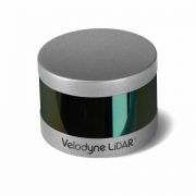
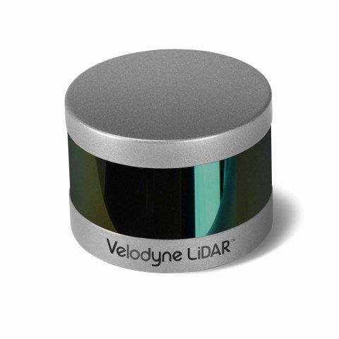
MORGAN HILL, Calif.–(BUSINESS WIRE)–Velodyne LiDAR Inc., the recognized global leader in Light, Detection and Ranging (LiDAR) technology, today unveiled its new Puck Hi-Res™ sensor, a version of the company’s groundbreaking LiDAR Puck that provides higher resolution in captured 3D images, which allows objects to be identified at greater distances. Puck Hi-Res is the third new LiDAR sensor released by the company this year, joining the standard VLP-16 Puck™ and the Puck LITE™.
“Not only does the Puck Hi-Res provide greater detail in longer ranges, but it retains all the functions of the original VLP-16 Puck that shook up these industries when it was introduced in September 2014.”
“Introducing a high-resolution LiDAR solution is essential to advancing any industry that leverages the capture of 3D images, from autonomous navigation to mapping to surveillance,” said Mike Jellen, President and COO, Velodyne LiDAR. “The Puck Hi-Res sensor will provide the most detailed 3D views possible from LiDAR, enabling widespread adoption of this technology while increasing safety and reliability.”
Expanding on Velodyne LiDAR’s groundbreaking VLP-16 Puck, a 16-channel, real-time 3D LiDAR sensor that weighs just 830 grams, Puck Hi-Res is used in applications that require greater resolution in the captured 3D image. Puck Hi-Res retains the VLP-16 Puck’s 360° horizontal field-of-view (FoV) and 100-meter range, but delivers a 20° vertical FoV for a tighter channel distribution – 1.33° between channels instead of 2.00° – to deliver greater details in the 3D image at longer ranges. This will enable the host system to not only detect, but also better discern, objects at these greater distances.
“Building on the VLP-16 Puck and the Puck LITE, the Puck Hi-Res was an intuitive next step for us, as the evolution of the various industries that rely on LiDAR showed the need for higher resolution 3D imaging,” said Wayne Seto, product line manager, Velodyne LiDAR. “Not only does the Puck Hi-Res provide greater detail in longer ranges, but it retains all the functions of the original VLP-16 Puck that shook up these industries when it was introduced in September 2014.”
“The 3D imaging market is expected to grow from $5.71B in 2015 to $15.15B in 2020, led by the development of autonomous shuttles for large campuses, airports, and basically anywhere there’s a need to safely move people and cargo,” said Dr. Rajender Thusu, Industry Principal for Sensors & Instruments, Frost & Sullivan. “We expect Velodyne LiDAR’s line of sensors to play a key role in this surge in autonomous vehicle development, as the company leads the way in partnerships with key industry drivers, along with the fact that sensors like the new Puck Hi-Res are substantially more sophisticated than competitive offerings and increasingly accessible to all industry players.”
Velodyne LiDAR is now accepting orders for Puck Hi-Res, with a lead-time of approximately eight weeks.
About Velodyne LiDAR
Founded in 1983 by David S. Hall, Velodyne Acoustics Inc. first disrupted the premium audio market through Hall’s patented invention of virtually distortion-less, servo-driven subwoofers. Hall subsequently leveraged his knowledge of robotics and 3D visualization systems to invent ground breaking sensor technology for self-driving cars and 3D mapping, introducing the HDL-64 Solid-State Hybrid LiDAR sensor in 2005. Since then, Velodyne LiDAR has emerged as the leading supplier of solid-state hybrid LiDAR sensor technology used in a variety of commercial applications including advanced automotive safety systems, autonomous driving, 3D mobile mapping, 3D aerial mapping and security. The compact, lightweight HDL-32E sensor is available for applications including UAVs, while the VLP-16 LiDAR Puck is a 16-channel LiDAR sensor that is both substantially smaller and dramatically less expensive than previous generation sensors. To read more about the technology, including white papers, visit http://www.velodynelidar.com.
Velodyne LiDAR
Laurel Nissen
lnissen@velodyne.com
or
Porter Novelli/Voce
Andrew Hussey
Andrew.hussey@porternovelli.com
SOFIA, BULGARIA (PRWEB) FEBRUARY 23, 2016 [Source]
Today, Chaos Group announces a new scanning technology that can produce an exact digital replica of a physical material with sub-mm precision. Design and manufacturing firms can instantly take advantage of this patented technology through VRscans, Chaos Group’s new full-service material scanning business.
“We’ve dedicated the last 19 years to advancing rendering technology, so designers can trust what they see on their screen. Now they can match the material sample in their hand with the one in their 3D model,” said Peter Mitev, CEO at Chaos Group.
While using digital graphics to prototype projects has been the standard for design firms and Fortune 500 companies for years, the ability to present products with 100% accuracy has not. In the past, approximations were used, forcing artists to spend countless hours getting 90% of the way there. With VRscans, companies can now send in their material samples, trusting that what comes back will be the most accurate representation of a digital material yet. Once processed, the materials are returned with a .vrscan file that arrives ready to render in V-Ray – Chaos Group’s widely-used photorealistic lighting and rendering software.
VRscans combines precise optical hardware with proprietary software; the result of several years of research and prototyping. VRscans captures each material’s full appearance, including surface texture, reflectivity, dimensionality, and its unique response to light. This complex data is read by the new VRscans plugin, creating a physically accurate material that can be rendered from any angle and in any lighting condition.
“Several pilot projects are already underway with top automotive, aerospace, and furniture companies,” said Dinko Dimitrov, VRscans Product Manager. “Digital prototypes are the best way to design quickly. Now designers can do it with confidence.”
Pricing and Availability
VRscans is available now and is compatible with the latest versions of V-Ray for 3ds Max and Maya. Support for additional applications is in development.
For information and pricing, email vrscans(at)chaosgroup(dot)com or visit http://www.vrscans.com.
About Chaos Group
Chaos Group is a worldwide leader in computer graphics technology that helps artists and designers create photoreal imagery and animation for design, television, and feature films. Chaos Group’s physically based lighting and rendering software V-Ray is used daily by top design studios, architectural firms, advertising agencies, and visual effects companies around the globe. Today, the company’s research and development in cloud rendering, material scanning, and virtual reality is shaping the future of creative storytelling and digital design. Founded in 1997, Chaos Group is privately owned with offices in Sofia, Los Angeles, Baltimore, Seoul, and Tokyo. For more information, visit: chaosgroup.com.

SCANable helped bring the Google Spotlight Stories fourth animated film to life by capturing all of the sets, locations, actors and vehicles in 3D for recreation of each item as photorealistic 3D digital assets. These assets were used by the VFX teams to create the final version of the film.
Source: TechCrunch.com
Google Spotlight Stories, a mobile app featuring immersive, 360-degree animated films originally developed by Motorola, has now made its way to iOS devices.
When viewers watch the movie, entitled “HELP” they can look anywhere, set the pace and frame the shot by moving their mobile device. Previously Spotlight Stories was only supported by Android but is now available to users of iOS 8.0 or higher.
The app itself is intended for entertainment purposes, as it offers stories built using 3D and 2D animations, 360-degree spherical “cinema-quality” video, sound sphere audio and “sensor fusion techniques,” explains Google. In short, what that means is that viewers can look around inside the animated content by moving their body and the phone to see different parts or angles of the story taking place.
Basically, the app can take advantage of the device’s sensors like its gyroscope and accelerometer in order to offer an immersive viewing experience. However, it doesn’t let end users create these sorts of movies for themselves.
One of the original animations featured in Spotlight Stories when it debuted was a film called “Windy Days” by ex-Pixar moviemakers, which appeared on Moto X phones when the Android app rolled out. This, as well as the other content previously available on Android, is also available in the new iOS app.
The app includes films like “Duet” from Glen Keane, “Buggy Night” from ATAP, and “Help” by “The Fast and the Furious” director Justin Lin. What’s interesting is that this latter movie, unlike the others, is noted as being “free for a limited time,” which indicates that Google may be planning to sell movies through this service in the future.
The technology for making these artistic mini-movies was first developed by Motorola Mobility’s Advanced Technology And Products (ATAP) moonshot division, but Google continued to fund its development in the years that followed. However, because the app was originally intended for Motorola devices (like the Moto X), it didn’t immediately support a wide range of Android devices when it launched. Some limitations on Android continue today, as the Google Play version still indicates that Spotlight Stories is “not yet compatible with all smartphones.”
However, the new iOS release will work on any device running iOS 8.0 or higher, notes Google.
The app is a free download, here on iTunes.
LAKE MARY, Fla., Jan. 7, 2015 /PRNewswire/ — FARO Technologies, Inc. (NASDAQ: FARO), the world’s most trusted source for 3D measurement, imaging, and realization technology, announces the release of the new FARO Freestyle3D Handheld Laser Scanner, an easy, intuitive device for use in Architecture, Engineering and Construction (AEC), Law Enforcement, and other industries.
The FARO Freestyle3D is equipped with a Microsoft Surface™ tablet and offers unprecedented real-time visualization by allowing the user to view point cloud data as it is captured. The Freestyle3D scans to a distance of up to three (3) meters and captures up to 88K points per second with accuracy better than 1.5mm. The patent-pending, self-compensating optical system also allows users to start scanning immediately with no warm up time required.
“The Freestyle3D is the latest addition to the FARO 3D laser scanning portfolio and represents another step on our journey to democratize 3D scanning,” stated Jay Freeland, FARO’s President and CEO. “Following the successful adoption of our Focus scanners for long-range scanning, we’ve developed a scanner that provides customers with the same intuitive feel and ease-of-use in a handheld device.”
The portability of Freestyle3D enables users to maneuver and scan in tight and hard-to-reach areas such as car interiors, under tables and behind objects making it ideal for crime scene data collection or architectural preservation and restoration activities. Memory-scan technology enables Freestyle3D users to pause scanning at any time and then resume data collection where they left off without the use of artificial targets.
Mr. Freeland added, “FARO’s customers continue to stress the importance of work-flow simplicity, portability, and affordability as key drivers to their continued use and adoption of 3D laser scanning. We have responded by developing an easy-to-use, industrial grade, handheld laser scanning device that weighs less than 2 lbs.”
The Freestyle3D can be employed as a standalone device to scan areas of interest, or used in concert with FARO’s Focus X 130 / X 330 scanners. Point cloud data from all of these devices can be seamlessly integrated and shared with all of FARO’s software visualization tools including FARO SCENE, WebShare Cloud, and FARO CAD Zone packages.
For more information about FARO’s 3D scanning solutions visit: www.faro.com
This press release contains forward-looking statements within the meaning of the Private Securities Litigation Reform Act of 1995 that are subject to risks and uncertainties, such as statements about demand for and customer acceptance of FARO’s products, and FARO’s product development and product launches. Statements that are not historical facts or that describe the Company’s plans, objectives, projections, expectations, assumptions, strategies, or goals are forward-looking statements. In addition, words such as “is,”“will,” and similar expressions or discussions of FARO’s plans or other intentions identify forward-looking statements. Forward-looking statements are not guarantees of future performance and are subject to various known and unknown risks, uncertainties, and otherfactors that may cause actual results, performances, or achievements to differ materially from future results, performances, or achievements expressed or implied by such forward-looking statements. Consequently, undue reliance should not be placed on these forward-looking statements.
Factors that could cause actual results to differ materially from what is expressed or forecasted in such forward-looking statements include, but are not limited to:
Forward-looking statements in this release represent the Company’s judgment as of the date of this release. The Company undertakes no obligation to update publicly any forward-looking statements, whether as a result of new information, future events, or otherwise, unless otherwise required by law.
About FARO
FARO is the world’s most trusted source for 3D measurement technology. The Company develops and markets computer-aided measurement and imaging devices and software. Technology from FARO permits high-precision 3D measurement, imaging and comparison of parts and complex structures within production and quality assurance processes. The devices are used for inspecting components and assemblies, rapid prototyping, documenting large volume spaces or structures in 3D, surveying and construction, as well as for investigation and reconstruction of accident sites or crime scenes.
Approximately 15,000 customers are operating more than 30,000 installations of FARO’s systems, worldwide. The Company’s global headquarters is located in Lake Mary, FL; its European regional headquarters in Stuttgart, Germany; and its Asia/Pacific regional headquarters in Singapore. FARO has other offices in the United States, Canada, Mexico, Brazil, Germany, the United Kingdom,France, Spain, Italy, Poland, Turkey, the Netherlands, Switzerland, Portugal, India, China, Malaysia, Vietnam, Thailand, South Korea, and Japan.
More information is available at http://www.faro.com
SOURCE FARO Technologies, Inc.
With Leica Cyclone 9.0, the industry leading point cloud solution for processing laser scan data, Leica Geosystems HDS introduces major, patent-pending innovations for greater project efficiency. Innovations benefit both field and office via significantly faster, easier scan registration, plus quicker deliverable creation thanks to better 2D and 3D drafting tools and steel modelling. Cyclone 9.0 allows users to scale easily for larger, more complex projects while ensuring high quality deliverables consistently.
Greatest advancement in office scan registration since cloud-to-cloud registration
When Leica Geosystems pioneered cloud-to-cloud registration, it enabled users – for the first time – to accurately execute laser scanning projects without having to physically place special targets around the scene, scan them, and model them in the office. With cloud-to-cloud registration software, users take advantage of overlaps among scans to register them together.
“The cloud-to-cloud registration approach has delivered significant logistical benefits onsite and time savings for many projects. We’ve constantly improved it, but the new Automatic Scan Alignment and Visual Registration capabilities in Cyclone 9.0 represent the biggest advancement in cloud-to-cloud registration since we introduced it,” explained Dr. Chris Thewalt, VP Laser Scanning Software. “Cyclone 9.0 lets users benefit from targetless scanning more often by performing the critical scan registration step far more efficiently in the office for many projects. As users increase the size and scope of their scanning projects, Cyclone 9.0 pays even bigger dividends. Any user who registers laser scan data will find great value in these capabilities.“
With the push of a button, Cyclone 9.0 automatically processes scans, and digital images if available, to create groups of overlapping scans that are initially aligned to each other. Once scan alignment is completed, algorithmic registration is applied for final registration. This new workflow option can be used in conjunction with target registration methods as well. These combined capabilities not only make the most challenging registration scenarios feasible, but also exponentially faster. Even novice users will appreciate their ease-of-use and ready scalability beyond small projects.
Power user Marta Wren, technical specialist at Plowman Craven Associates (PCA – leading UK chartered surveying firm) found that Cyclone 9.0’s Visual Registration tools alone sped up registration processing of scans by up to four times (4X) faster than previous methods. PCA uses laser scanning for civil infrastructure, commercial property, forensics, entertainment, and Building Information Modelling (BIM) applications.
New intuitive 2D and 3D drafting from laser scans
For civil applications, new roadway alignment drafting tools let users import LandXML-based roadway alignments or use simple polylines imported or created in Cyclone. These tools allow users to easily create cross section templates using feature codes, as well as copy them to the next station and visually adjust them to fit roadway conditions at the new location. A new vertical exaggeration tool in Cyclone 9.0 allows users to clearly see subtle changes in elevation; linework created between cross sections along the roadway can be used as breaklines for surface meshing or for 2D maps and drawings in other applications.
For 2D drafting of forensic scenes, building and BIM workflows, a new Quick Slice tool streamlines the process of creating a 2D sketch plane for drafting items, such as building footprints and sections, into just one step. A user only needs to pick one or two points on the face of a building to get started. This tool can also be used to quickly analyse the quality of registrations by visually checking where point clouds overlap.
Also included in Cyclone 9.0 are powerful, automatic point extraction features first introduced in Cyclone II TOPO and Leica CloudWorx. These include efficient SmartPicks for automatically finding bottom, top, and tie point locations and Points-on-a-Grid for automatically placing up to a thousand scan survey points on a grid for ground surfaces or building faces.
Simplified steel fitting of laser scan data
For plant, civil, building and BIM applications, Cyclone 9.0 also introduces a patent-pending innovation for modelling steel from point cloud data more quickly and easily. Unlike time consuming methods that require either processing an entire available cloud to fit a steel shape or isolating a cloud section before fitting, this new tool lets users to quickly and accurately model specific steel elements directly within congested point clouds. Users only need to make two picks along a steel member to model it. Shapes include wide flange, channel, angle, tee, and rectangular tube shapes.
Faster path to deliverables
Leica Cyclone 9.0 also provides users with valuable, new capabilities for faster creation of deliverables for civil, architectural, BIM, plant, and forensic scene documentation from laser scans and High-Definition Surveying™ (HDS™).
Availability
Leica Cyclone 9.0 is available today. Further information about the Leica Cyclone family of products can be found at http://hds.leica-geosystems.com, and users may download new product versions online from this website or purchase or rent licenses from SCANable, your trusted Leica Geosystems representative. Contact us today for pricing on software and training.
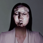
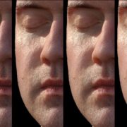
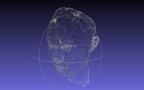
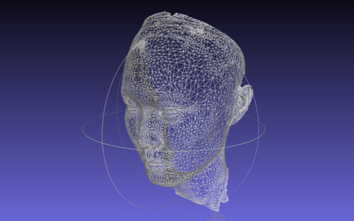
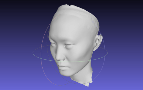
Forget the faces of historic monuments, the new frontier of 3D projection mapping is the faces of humans.
Created by Nobumichi Asai and friends, technical details behind the process are scant at the moment, but from what can be found in this Tumblr post, it’s clear that step one is a 3D scan of the model’s face.
Here is the translated text from that post:
I will continue to explain how to make a face mapping of this time.
Title OMOTE that (= table) is coming from the “ability”, but it has become the idea of Noh mask also in how to make. That is the idea, covered by creating a “surface”. That it is possible to pursue the accuracy, theme that represent a very delicate make-up art as its output was important. I started from the fact that it is 3D laser scanning the face of the model for the first.
I suspect that a structured light scanner was used to capture the geometry of the model’s face rather than a 3D laser scanner. Nonetheless, this is a very cool application of 3D projection mapping.
OMOTE / REAL-TIME FACE TRACKING & PROJECTION MAPPING. from something wonderful on Vimeo.