Shot on Lytro’s Light-field Camera, ‘Hallelujah’ Is a Stunning Mix of Volumetric Film and Audio
/0 Comments/in In the News, New Hardware, New Technology, News, Visual Effects (VFX)/by Ty TaylorFaceware Announces New Facial Motion Capture Hardware
/0 Comments/in New Hardware, News/by Travis ReinkeLeica Geosystems and Autodesk Announce BLK360 $16k 3D Laser Scanner
/0 Comments/in 3D Laser Scanning, LiDAR, New Hardware, New Technology, News, Point Cloud/by Travis ReinkeLeica Geosystems Announces Complete Imaging Solution: Leica BLK360 Imaging Laser Scanner and Autodesk ReCap 360 Pro App
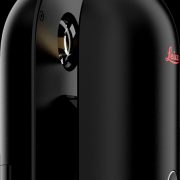
Las Vegas, November 16th, 2016, Leica Geosystems announced the BLK360, a revolutionary miniaturized black 3D imaging laser scanner. The product was revealed at Autodesk University 2016 and will be bundled with Autodesk’s ReCap 360 Pro and the new ReCap 360 Pro app for iPad. Both companies will demonstrate the product for the duration of the conference at the ReCap booth #2033 and the Leica Geosystems booth #1537.
The BLK360 captures the world around you with full-color panoramic images overlaid on a high accuracy point cloud. The one-button Leica BLK360 is not only the smallest and lightest of its kind, but also offers a simple user experience. Anyone who can operate an iPad can now capture the world around them with high resolution 3D panoramic images.
The Leica BLK360 defines a new category: the imaging laser scanner. It is so small and light that it fits in a typical messenger bag and can be carried almost anywhere. It features a 60 meter measurement range for full dome scans. A complete full-dome laser scan, 3D panoramic image capture and transfer to the iPad Pro takes only 3 minutes.
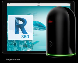 Using the ReCap Pro 360 mobile app, the BLK360 streams image and point cloud data to iPad. The app filters and registers scan data in real-time. After capture, ReCap 360 Pro enables for point cloud data transfer to a number of CAD, BIM, VR and AR applications. The integration of BLK360 and Autodesk software will dramatically streamline the reality capture process thereby opening this technology to non-surveying individuals.
“When Autodesk first introduced ReCap, it was for one purpose: the democratization of reality capture,” said Aaron Morris, who oversees reality solutions at Autodesk. “We saw the tremendous power of this technology for the AEC industry, but realized that the cost and portability of scanners combined with difficult-to-use data was limiting the adoption of reality capture. Autodesk’s collaboration with Leica Geosystems helps solve these issues by giving just about anyone access to the amazing advantages of reality data.”
“As the leader in the spatial measurement arena, we recognized the gap between Leica Geosystems’ scientific-grade 3D laser scanners and emerging camera and handheld technologies, and set out to bring reality capture to everyone,” said Dr. Burkhard Boeckem, CTO of Hexagon Geosystems. “By combining and miniaturizing technologies available within Hexagon, the BLK360 defines a new category: the Imaging Laser Scanner. It is significantly smaller and lighter (1 kg) than any comparable device on the market. As we developed the ultimate sensor, we worked with Autodesk to create new software and ultimately achieved the next milestone in 3D reality capture. Together with Autodesk’s ReCap 360 Pro, the Leica BLK360 empowers every AEC professional to realize the benefits gained by incorporating high resolution 360° imagery and 3D laser scan data in their daily work.”
BLK360 & Autodesk ReCap 360 Pro Bundle will be available to order in March 2017. The anticipated bundle suggested retail price is $15,990/€15,000, which includes: BLK360 Scanner, Case, Battery, Charger and an annual subscription to ReCap 360 Pro. For customers who want to secure their spot in line to receive the first batch of BLK360 laser scanners, Autodesk and Leica Geosystems are offering a special limited promotion for a discounted three-year ReCap 360 Pro subscription with a voucher giving priority access to buy the BLK360. Go to this link to learn more.
Leica Geosystems – when it has to be right
Revolutionizing the world of measurement and survey for nearly 200 years, Leica Geosystems creates complete solutions for professionals across the planet. Known for premium products and innovative solution development, professionals in a diverse mix of industries, such as aerospace and defense, safety and security, construction, and manufacturing, trust Leica Geosystems for all their geospatial needs. With precise and accurate instruments, sophisticated software, and trusted services, Leica Geosystems delivers value every day to those shaping the future of our world.
Leica Geosystems is part of Hexagon (Nasdaq Stockholm: HEXA B; hexagon.com), a leading global provider of information technologies that drive quality and productivity improvements across geospatial and industrial enterprise applications.
Autodesk, the Autodesk logo, Autodesk ReCap 360, and Autodesk ReCap 360 Pro are registered trademarks or trademarks of Autodesk, Inc., and/or its subsidiaries and/or affiliates in the USA and/or other countries. All other brand names, product names or trademarks belong to their respective holders. Autodesk reserves the right to alter product and services offerings, and specifications and pricing at any time without notice, and is not responsible for typographical or graphical errors that may appear in this document.
Google Brings Its 360-Degree Movies App, Spotlight Stories, To iOS
/0 Comments/in 3D Laser Scanning, In the News, Industry, New Technology, News, Software/by Travis ReinkeSCANable helped bring the Google Spotlight Stories fourth animated film to life by capturing all of the sets, locations, actors and vehicles in 3D for recreation of each item as photorealistic 3D digital assets. These assets were used by the VFX teams to create the final version of the film.
Source: TechCrunch.com
Google Spotlight Stories, a mobile app featuring immersive, 360-degree animated films originally developed by Motorola, has now made its way to iOS devices.
When viewers watch the movie, entitled “HELP” they can look anywhere, set the pace and frame the shot by moving their mobile device. Previously Spotlight Stories was only supported by Android but is now available to users of iOS 8.0 or higher.
The app itself is intended for entertainment purposes, as it offers stories built using 3D and 2D animations, 360-degree spherical “cinema-quality” video, sound sphere audio and “sensor fusion techniques,” explains Google. In short, what that means is that viewers can look around inside the animated content by moving their body and the phone to see different parts or angles of the story taking place.
Basically, the app can take advantage of the device’s sensors like its gyroscope and accelerometer in order to offer an immersive viewing experience. However, it doesn’t let end users create these sorts of movies for themselves.
One of the original animations featured in Spotlight Stories when it debuted was a film called “Windy Days” by ex-Pixar moviemakers, which appeared on Moto X phones when the Android app rolled out. This, as well as the other content previously available on Android, is also available in the new iOS app.
The app includes films like “Duet” from Glen Keane, “Buggy Night” from ATAP, and “Help” by “The Fast and the Furious” director Justin Lin. What’s interesting is that this latter movie, unlike the others, is noted as being “free for a limited time,” which indicates that Google may be planning to sell movies through this service in the future.
The technology for making these artistic mini-movies was first developed by Motorola Mobility’s Advanced Technology And Products (ATAP) moonshot division, but Google continued to fund its development in the years that followed. However, because the app was originally intended for Motorola devices (like the Moto X), it didn’t immediately support a wide range of Android devices when it launched. Some limitations on Android continue today, as the Google Play version still indicates that Spotlight Stories is “not yet compatible with all smartphones.”
However, the new iOS release will work on any device running iOS 8.0 or higher, notes Google.
The app is a free download, here on iTunes.
Emmy Nomination for Nissan “With Dad” Commercial
/0 Comments/in In the News, News/by Travis ReinkeDo you recall the emotional Nissan television ad that was introduced during Super Bowl XLIX earlier this year? It made the list of 2015 Emmy nominations for Outstanding Commercial, and we are not surprised. Refresh your memory and watch it again.
This sentimental commercial, titled “With Dad,” certainly caught the public’s attention. After it premiered during the Super Bowl, the ad was voted the Favorite Super Bowl Commercial of 2015 and received more than 22 million views on YouTube. Nissan definitely made a bang after opting not to advertise during the Super Bowl in nearly twenty years!
As you can see, the commercial takes viewers through the lives of a loving family working its way through tough times and struggling to stay close despite the circumstances. Nissan took the opportunity to introduce two new Nissan models, the GT-R LM NISMO sports car and 2016 Nissan Maxima sports sedan.
Nissan #withdad campaign
The popular commercial ran as part of Nissan’s #withdad campaign, aimed toward reminding the public how much more fun and exciting life can be with dad. In addition to the Super Bowl commercial and other YouTube videos, Nissan also donated $1,000,000 to a couple organizations that help individuals make better lives for them and their families–Habitat for Humanity and Wounded Warrior Project.
Source: Sorg Nissan
Shade VFX Nominated for an Emmy Award for Daredevil
/0 Comments/in 3D Laser Scanning, Events, In the News, News, Visual Effects (VFX)/by Travis ReinkeDaredevil, The Netflix Original Series, has been nominated for three Emmy awards in 2015, including one for Shade VFX in the category of Best Supporting Visual Effects. SCANable partnered with Shade VFX on this project by providing 3D scans of sets and actors used for camera tracking and matchmoving.
Source: Shade VFX
At the 67th Primetime Emmy Awards the Best Supporting Visual Effects category will award seamless, invisible effects in a television series and we’re utterly thrilled to be in the running alongside American Horror Story: Freak Show, Boardwalk Empire, Gotham, and The Walking Dead.
Daredevil, as we’ve discussed previously, was a unique opportunity for Shade VFX to expand both into New York and into the world of exceptional television working alongside Netflix and Marvel.
We created invisible effects that were a showpiece of the series, propelling the gritty and dark crime story forward and making your palms sweaty with action along the way.
Congratulations to the whole team that worked on Daredevil; Visual Effects Producer, David Van Dyke, Visual Effects Supervisors, Bryan Godwin and Karl Coyner, as well as Senior Compositing Lead, Steve J. Sanchez, Visual Effects Coordinator, Julie Long, Visual Effects Editor, Pedro Tarrago, Associate Compositing Lead, Neiko Nagy, CG Artist, Moshe Swed, and FX Technical Director, Kjell Strode.
Best of luck also to the Shade VFX team and all the other vendors for their nomination for Best Visual Effects for Black Sails! Particular congratulations of course to Chip Baden, who will be representing the Team Shade in this category.
Sincere thanks to Academy of Television Arts and Sciences, Marvel and Netflix.
Leica Pegasus Backpack Wearable Reality Capture – Indoors, Outdoors, Anywhere
/0 Comments/in 3D Laser Scanning, LiDAR, Mobile Scanning, News, Point Cloud/by Travis ReinkeUltra mobile reality capture sensor platform – authoritative professional documentation indoors or outdoors
Leica Pegasus Backpack is a unique wearable reality capturing sensor platform combining cameras and Lidar profilers with the lightness of a carbon fiber chassis and a highly ergonomic design. The Pegasus:Backpack enables extensive and efficient indoor or outdoor documentation at a level of accuracy that is authoritative and professional. The Pegasus:Backpack is designed for rapid and regular reality capture – no longer is scanning registration needed for progressive scanning. The Pegasus:Backpack is just completely portable – enabling it to be checked in as luggage on a flight – simply fly-in, wear, collect, then fly-out. As part of the Pegasus platform, the Pegasus:Backpack is designed to act as a sensor platform with our standard external trigger and sync port outputs.
Leica Pegasus:Backpack
Map indoors, outdoors, underground, anywhere
Making progressive professional BIM documentation a reality with the Leica Pegasus:Backpack solution, synchronising imagery and point cloud data together, therefore assuring a complete documentation of a building for full life cycle management. By using SLAM (Simultaneous Localization and Mapping) technology and a high precision IMU, we ensure accurate positioning with GNSS outages – ensuring the best known position independent of how it is used.
With the Leica Pegasus:Backpack outdoor areas or underground infrastructures with limited access professional data collection is no longer limited . By capturing full 360 spherical view and Lidar together means you never forget an object or return to a project site – no matter where you are. A hardware light sensor ensures the operator that all images are usable while other functions are verifiable and adjustable over the operators tablet device.
Main features
- Indoor and outdoor mapping in one single solution – position agnostic
- Marries imagery and point cloud data into a single calibrated, user-intuitive platform
- Full calibrated spherical view
- External trigger output and external time stamping for additional sensors
- Light sensor for auto brightness and balance control for image capture
- Software enables access to Esri® ArcGIS for Desktop
- Capture and edit 3D spatial objects from images and / or within the point cloud
- Economical with data – balances data quantity and quality, with project logistics and post-processing
- Ultra light weight carbon fiber core frame with an extensive ergonomic support for prolonged use
- Real time view of the captured data through the tablet device
- Up to 6 hours operational time with optional battery pack
Hardware features
- Two profilers with 600,000 pts/sec, 50 m usable range and 16 channels
- Largest sensor to pixel in the market – 5.5 um x 5.5 um
- Five 4 MB cameras positioned to capture 360° x 200° view
- User adjustable acquisition intervals based on the distance travelled
- NovAtel ProPak6™ provides the latest and most sophisticated precise GNSS receiver with a robust field proven IMU for position accuracy of 20 mm RMS after 10 seconds of outage
- Marrying a triple band GNSS system with the latest multiple beam enabled SLAM algorithms
- INS determination of the location, speed, velocity and orientation at a rate of 200 Hz
- Ultra portable system fitting into one carrying case (system weight 13 kg)
- Battery based – using four batteries in a hot swappable configuration
- Multi-core industrial PC, 1 TB SSD, USB3 interface, ethernet, and wireless connection from the system to the tablet device

Leica Pegasus:Backpack enables unimaginable applications for indoor and outdoor mapping combining visual images with the accuracy of a point cloud for professional documentation – in a wearable, ergonomic, and ultra light carbon fiber construction.
Software features
- User capable of adding acquisition point objects in a Shapefile format during data acquisition
- Advanced export capability for CAD-systems and others (DWG, DXF, SHP, GDB, DGN, E57, HPC, LAS, PTS, NMEA, KMZ)
- Semi-automatic extraction tools
- Sequenced images and videos for rapid navigation and object recognition
- Software pointer “snaps” automatically and continuously onto the point cloud data from within an image
- Immediate access to point clouds for accurate measurement
- 3D stereoscopic view to decrease errors and increase throughput
- Shadowed or missing 3D points can be acquired via photogrammetric processes
- Data capture module displays the current location based on a GIS user interface
- Data capture module displays all cameras and Lidar scans live, simultaneously
- Data capture module enables laser scanner management and GNSS Operation
- Live status monitoring of system during data acquisition
Software benefits
- Lidar accuracy with image-based usability
- Digitise spatial objects through mobile mapping
- A more natural approach for non-professional users while offering technical interface for advanced users
- Scalable to your applications including less accurate simple GIS needs
- Short data acquisition time
- High acquisition throughput
- High post-processing throughput
- Manageable license options – compatible with thin-client viewer
- Esri® ArcGIS for Desktop compatible
- Leverages Esri® relational platform for advanced features
[TC]2 Announces Availability of Its Most Advanced 3D/4D Body Scanner
/0 Comments/in 3D Laser Scanning, In the News, News, Point Cloud, Visual Effects (VFX)/by Travis ReinkeNew TC2-19 Offers Fastest and Most Accurate Measurements on the Market [source]
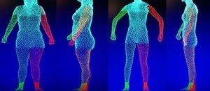 Cary, NC – April 30, 2015 – [TC]², the innovation leader for the fashion industry and 3D body scanning technology, announces general availability of the TC2-19, the most advanced 3D/4D body scanning and measurement technology available on the market.
The TC2-19 provides the option of using a touch screen inside the scanner booth which allows users to “self-scan” by following on-screen instructions. The “self-scan mode” is ideal for use with the iStyling™ Full Retail Solution that provides for greater fit accuracy, styling advice, and garment customization. The body scanner interfaces with multiple CAD technologies and avatar engines.
While capturing the accurate body measurements that [TC]² 3D body scanners are well-known for today, the TC2-19 offers a “quick scan” option (2 seconds), 360° 3D body scanning and rapid processing speeds (17 seconds). The newly developed 4D mode enables 3D movement visualization inside the scanner.
“The combination of speed, accuracy, and stability enabled by software and hardware advancements make this the most advanced 3D/4D body scanner ever built”, said Dr. Mike Fralix, CEO of [TC]². “We are excited that our existing retail customers and major brands now have a scalable solution that can easily and cost effectively roll out to multiple locations.”
The [TC]² body scanner captures thousands of body measurements used by the fashion, medical, and fitness industries to make custom garments, predict customer sizing, benchmark fitness goals, and augment surgical processes. The scanner fits in a space the size of the average retail dressing room and features a booth for privacy. The TC2-19 comes with a lifetime scanner software license and PC.
The TC2-19 can be viewed at the [TC]² National Apparel Technology Center in Cary, N.C.
About [TC]²:
[TC]², Textile / Clothing and Technology Corporation, is a leader in innovation and dedicated to the advancement of the fashion and sewn products industry. Its research, consulting services, and products help brands, retailers, and manufacturers provide increased value for their customers while improving their bottom line. [TC]²’s mission focuses on the development, promotion and implementation of new technologies and ideas that significantly impact the industry.
Leica Geosystems HDS Introduces Patent-Pending Innovations for Laser Scanning Project Efficiency
/0 Comments/in LiDAR, New Technology, News, Point Cloud, Software, Visual Effects (VFX)/by Travis ReinkeWith Leica Cyclone 9.0, the industry leading point cloud solution for processing laser scan data, Leica Geosystems HDS introduces major, patent-pending innovations for greater project efficiency. Innovations benefit both field and office via significantly faster, easier scan registration, plus quicker deliverable creation thanks to better 2D and 3D drafting tools and steel modelling. Cyclone 9.0 allows users to scale easily for larger, more complex projects while ensuring high quality deliverables consistently.
Greatest advancement in office scan registration since cloud-to-cloud registration
When Leica Geosystems pioneered cloud-to-cloud registration, it enabled users – for the first time – to accurately execute laser scanning projects without having to physically place special targets around the scene, scan them, and model them in the office. With cloud-to-cloud registration software, users take advantage of overlaps among scans to register them together.
“The cloud-to-cloud registration approach has delivered significant logistical benefits onsite and time savings for many projects. We’ve constantly improved it, but the new Automatic Scan Alignment and Visual Registration capabilities in Cyclone 9.0 represent the biggest advancement in cloud-to-cloud registration since we introduced it,” explained Dr. Chris Thewalt, VP Laser Scanning Software. “Cyclone 9.0 lets users benefit from targetless scanning more often by performing the critical scan registration step far more efficiently in the office for many projects. As users increase the size and scope of their scanning projects, Cyclone 9.0 pays even bigger dividends. Any user who registers laser scan data will find great value in these capabilities.“
With the push of a button, Cyclone 9.0 automatically processes scans, and digital images if available, to create groups of overlapping scans that are initially aligned to each other. Once scan alignment is completed, algorithmic registration is applied for final registration. This new workflow option can be used in conjunction with target registration methods as well. These combined capabilities not only make the most challenging registration scenarios feasible, but also exponentially faster. Even novice users will appreciate their ease-of-use and ready scalability beyond small projects.
Power user Marta Wren, technical specialist at Plowman Craven Associates (PCA – leading UK chartered surveying firm) found that Cyclone 9.0’s Visual Registration tools alone sped up registration processing of scans by up to four times (4X) faster than previous methods. PCA uses laser scanning for civil infrastructure, commercial property, forensics, entertainment, and Building Information Modelling (BIM) applications.
New intuitive 2D and 3D drafting from laser scans
For civil applications, new roadway alignment drafting tools let users import LandXML-based roadway alignments or use simple polylines imported or created in Cyclone. These tools allow users to easily create cross section templates using feature codes, as well as copy them to the next station and visually adjust them to fit roadway conditions at the new location. A new vertical exaggeration tool in Cyclone 9.0 allows users to clearly see subtle changes in elevation; linework created between cross sections along the roadway can be used as breaklines for surface meshing or for 2D maps and drawings in other applications.
For 2D drafting of forensic scenes, building and BIM workflows, a new Quick Slice tool streamlines the process of creating a 2D sketch plane for drafting items, such as building footprints and sections, into just one step. A user only needs to pick one or two points on the face of a building to get started. This tool can also be used to quickly analyse the quality of registrations by visually checking where point clouds overlap.
Also included in Cyclone 9.0 are powerful, automatic point extraction features first introduced in Cyclone II TOPO and Leica CloudWorx. These include efficient SmartPicks for automatically finding bottom, top, and tie point locations and Points-on-a-Grid for automatically placing up to a thousand scan survey points on a grid for ground surfaces or building faces.
Simplified steel fitting of laser scan data
For plant, civil, building and BIM applications, Cyclone 9.0 also introduces a patent-pending innovation for modelling steel from point cloud data more quickly and easily. Unlike time consuming methods that require either processing an entire available cloud to fit a steel shape or isolating a cloud section before fitting, this new tool lets users to quickly and accurately model specific steel elements directly within congested point clouds. Users only need to make two picks along a steel member to model it. Shapes include wide flange, channel, angle, tee, and rectangular tube shapes.
Faster path to deliverables
Leica Cyclone 9.0 also provides users with valuable, new capabilities for faster creation of deliverables for civil, architectural, BIM, plant, and forensic scene documentation from laser scans and High-Definition Surveying™ (HDS™).
Availability
Leica Cyclone 9.0 is available today. Further information about the Leica Cyclone family of products can be found at http://hds.leica-geosystems.com, and users may download new product versions online from this website or purchase or rent licenses from SCANable, your trusted Leica Geosystems representative. Contact us today for pricing on software and training.
Quick Pages
Recent Productions
Latest News
 A $1.5B Investment in Texas’ Film is Now LawJune 23, 2025 - 4:49 pm
 Daredevil: Born Again: the art and craft of critical VFX collaborationMay 3, 2025 - 1:58 pm
 Here are all the nominees for the 23rd Annual VES AwardsJanuary 15, 2025 - 6:58 pm
