Loading
SCANable
  • Home
  • About Us
    • COVID-19 Response
    • News
  • Services
    • Request 3D Scanning Services
      • Architecture & Heritage
      • Civil/Survey
      • Plant, Process & Marine
      • Security and Threat Analysis
      • Training and Support
    • Mobile Photogrammetry Studios
    • C.A.L.V.I.N.N.™ Camera Array for Lightfields, Volumetrics, Imaging, and Neural Networks
    • Virtual Production Support
    • Drone Photogrammetry
    • Digital Doubles
    • Sets and Environments
    • Props and Products
    • Vehicles
    • Rentals
  • Recent Productions
  • Locations
    • Los Angeles
    • New York
    • Atlanta
    • New Orleans
    • Houston
  • Contact
  • Click to open the search input field Click to open the search input field Search
  • Menu Menu
Leica_Pegasus_Backpack_Keyvisual_PIC_655x180

Leica Pegasus Backpack Wearable Reality Capture – Indoors, Outdoors, Anywhere

June 3, 2015/0 Comments/in 3D Laser Scanning, LiDAR, Mobile Scanning, News, Point Cloud/by Travis Reinke

Ultra mobile reality capture sensor platform – authoritative professional documentation indoors or outdoors

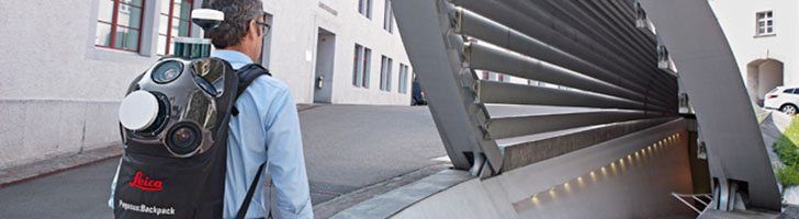
Leica Pegasus Backpack is a unique wearable reality capturing sensor platform combining cameras and Lidar profilers with the lightness of a carbon fiber chassis and a highly ergonomic design. The Pegasus:Backpack enables extensive and efficient indoor or outdoor documentation at a level of accuracy that is authoritative and professional. The Pegasus:Backpack is designed for rapid and regular reality capture – no longer is scanning registration needed for progressive scanning. The Pegasus:Backpack is just completely portable – enabling it to be checked in as luggage on a flight – simply fly-in, wear, collect, then fly-out. As part of the Pegasus platform, the Pegasus:Backpack is designed to act as a sensor platform with our standard external trigger and sync port outputs.

Leica Pegasus:Backpack

Map indoors, outdoors, underground, anywhere
Making progressive professional BIM documentation a reality with the Leica Pegasus:Backpack solution, synchronising imagery and point cloud data together, therefore assuring a complete documentation of a building for full life cycle management. By using SLAM (Simultaneous Localization and Mapping) technology and a high precision IMU, we ensure accurate positioning with GNSS outages – ensuring the best known position independent of how it is used.

With the Leica Pegasus:Backpack outdoor areas or underground infrastructures with limited access professional data collection is no longer limited . By capturing full 360 spherical view and Lidar together means you never forget an object or return to a project site – no matter where you are. A hardware light sensor ensures the operator that all images are usable while other functions are verifiable and adjustable over the operators tablet device.


Main features

  • Indoor and outdoor mapping in one single solution – position agnostic
  • Marries imagery and point cloud data into a single calibrated, user-intuitive platform
  • Full calibrated spherical view
  • External trigger output and external time stamping for additional sensors
  • Light sensor for auto brightness and balance control for image capture
  • Software enables access to Esri® ArcGIS for Desktop
  • Capture and edit 3D spatial objects from images and / or within the point cloud
  • Economical with data – balances data quantity and quality, with project logistics and post-processing
  • Ultra light weight carbon fiber core frame with an extensive ergonomic support for prolonged use
  • Real time view of the captured data through the tablet device
  • Up to 6 hours operational time with optional battery pack

Hardware features

  • Two profilers with 600,000 pts/sec, 50 m usable range and 16 channels
  • Largest sensor to pixel in the market – 5.5 um x 5.5 um
  • Five 4 MB cameras positioned to capture 360° x 200° view
  • User adjustable acquisition intervals based on the distance travelled
  • NovAtel ProPak6™ provides the latest and most sophisticated precise GNSS receiver with a robust field proven IMU for position accuracy of 20 mm RMS after 10 seconds of outage
  • Marrying a triple band GNSS system with the latest multiple beam enabled SLAM algorithms
  • INS determination of the location, speed, velocity and orientation at a rate of 200 Hz
  • Ultra portable system fitting into one carrying case (system weight 13 kg)
  • Battery based – using four batteries in a hot swappable configuration
  • Multi-core industrial PC, 1 TB SSD, USB3 interface, ethernet, and wireless connection from the system to the tablet device

Leica Pegasus:Backpack Indoor mapping solution

Leica Pegasus:Backpack enables unimaginable applications for indoor and outdoor mapping combining  visual images with the accuracy of a point cloud for professional documentation – in a wearable, ergonomic, and ultra light carbon fiber construction.

Software features

  • User capable of adding acquisition point objects in a Shapefile format during data acquisition
  • Advanced export capability for CAD-systems and others (DWG, DXF, SHP, GDB, DGN, E57, HPC, LAS, PTS, NMEA, KMZ)
  • Semi-automatic extraction tools
  • Sequenced images and videos for rapid navigation and object recognition
  • Software pointer “snaps” automatically and continuously onto the point cloud data from within an image
  • Immediate access to point clouds for accurate measurement
  • 3D stereoscopic view to decrease errors and increase throughput
  • Shadowed or missing 3D points can be acquired via photogrammetric processes
  • Data capture module displays the current location based on a GIS user interface
  • Data capture module displays all cameras and Lidar scans live, simultaneously
  • Data capture module enables laser scanner management and GNSS Operation
  • Live status monitoring of system during data acquisition

Software benefits

  • Lidar accuracy with image-based usability
  • Digitise spatial objects through mobile mapping
  • A more natural approach for non-professional users while offering technical interface for advanced users
  • Scalable to your applications including less accurate simple GIS needs
  • Short data acquisition time
  • High acquisition throughput
  • High post-processing throughput
  • Manageable license options – compatible with thin-client viewer
  • Esri® ArcGIS for Desktop compatible
  • Leverages Esri® relational platform for advanced features
Share this entry
  • Share on Facebook
  • Share on X
  • Share on WhatsApp
  • Share on Pinterest
  • Share on LinkedIn
  • Share on Tumblr
  • Share on Vk
  • Share on Reddit
  • Share by Mail
https://scanable.com/wp-content/uploads/2015/06/Leica_Pegasus_Backpack_Keyvisual_PIC_655x1801.jpg 200 728 Travis Reinke https://scanable.com/wp-content/uploads/2025/01/SCANable_logo_emblemSimple-180x180.png Travis Reinke2015-06-03 20:26:252015-06-03 20:29:11Leica Pegasus Backpack Wearable Reality Capture – Indoors, Outdoors, Anywhere
0 replies

Leave a Reply

Want to join the discussion?
Feel free to contribute!

Leave a Reply Cancel reply

Your email address will not be published. Required fields are marked *

Pages

  • 2023 Trilith Charity Gala
  • 3D Body Scanning, LiDAR and VFX Support in Houston, Texas
  • 3D Head and Body Scanning
  • 3D Object Scanning
  • 3D Scanning & VFX Capture in Los Angeles
  • 3D Scanning & VFX Capture in Texas | SCANable
  • 3D Scanning, Drone Photogrammetry & LiDAR in Atlanta | SCANable
  • 3D Scanning, Drone Photogrammetry & LiDAR in New York City | SCANable
  • 3D VFX LiDAR Scanning and Support in New Orleans, Louisiana
  • 3D VFX Scanning and Support in Atlanta, Georgia
  • 3D VFX Scanning and Support in Los Angeles, California
  • 3D VFX Scanning and Support in New York
  • About Us
  • Architecture & Heritage
  • Artec Leo
  • Asset
  • Awards
  • Blog
  • C.A.L.V.I.N.N.™ Camera Array for Lightfields, Volumetrics, Imaging, and Neural Networks
  • Cart
  • Checkout
  • Civil/Survey
  • Clients
  • Contact
  • Drone Photogrammetry
  • FARO Focus S 150 and 350 3D Laser Scanner
  • FARO Focus3D X 330 Long Range 3D Laser Scanner
  • FARO Freestyle3D Handheld Scanner
  • Home
  • Industry News
  • Leica HDS6200
  • LiDAR Location and Environment 3D Scanning
  • Logout
  • Maquette, Statues and Fine Art 3D scanning
  • Mobile 3D Scanning
  • Mobile Photogrammetry Studios
  • MoPho 1 Service Request
  • MoPho 2 Service Request
  • MoPho 3 Service Request
  • My Account
  • New
  • News
  • Plant, Process & Marine
  • Pricing and FAQ
  • Privacy Policy
  • Purchase Affordable 3D Laser Scanners
  • Recent Productions
  • Rent the Leica RTC360
  • Request 3D Scanning Services
  • SCANable Rig Checklist
  • SCANable UAS (Unmanned Aerial Systems)
  • SCANable | COVID-19 Response
  • Security and Threat Analysis
  • Services
  • Shop
  • Surphaser 100HSX
  • Trailer Move
  • Training and Support
  • VFX 3D Vehicle Scanning For Film and Television
  • VFX is not AI
  • Virtual Reality
  • Visual Effects/CGI

Categories

  • 3D Laser Scanning
  • 3D Printing
  • Animation
  • Archaeology
  • Blog
  • Building Information Modeling (BIM)
  • Events
  • Featured
  • Forensic
  • Government
  • In the News
  • Industrial
  • Industry
  • LiDAR
  • Mobile Scanning
  • Modeling
  • New Hardware
  • New Technology
  • News
  • Photogrammetry
  • Point Cloud
  • Reviews
  • Software
  • Uncategorized
  • Virtual Reality
  • Visual Effects (VFX)

Archive

  • June 2025
  • May 2025
  • January 2025
  • December 2024
  • November 2022
  • October 2020
  • August 2020
  • July 2020
  • June 2020
  • January 2020
  • July 2017
  • May 2017
  • April 2017
  • December 2016
  • November 2016
  • October 2016
  • September 2016
  • July 2016
  • May 2016
  • March 2016
  • September 2015
  • June 2015
  • May 2015
  • March 2015
  • January 2015
  • December 2014
  • November 2014
  • August 2014
  • June 2014
  • April 2014
  • March 2014
  • February 2014
  • January 2014
  • November 2013
  • June 2013
  • March 2013
  • January 2013
  • December 2012
  • November 2012
  • September 2012
  • August 2012
  • July 2012
  • December 2010
  • November 2010
  • October 2010
  • August 2010
  • May 2010
  • April 2010
  • March 2010
  • February 2010
  • January 2010
  • December 2009
  • November 2009
  • October 2009
  • September 2009
  • August 2009
  • July 2009
  • June 2009
  • May 2009

Quick Pages

  • Home
  • News
  • Services
  • Contact
  • Privacy Policy

Recent Productions

  • Play Dirty (Prime Video)
  • Peacemaker (DC Studios)
  • Marty Supreme (A24)
  • Superman (DC Studios)
  • Happy Gilmore 2 (Netflix)

Categories

  • 3D Laser Scanning
  • 3D Printing
  • Animation
  • Archaeology
  • Blog
  • Building Information Modeling (BIM)
  • Events
  • Featured
  • Forensic
  • Government
  • In the News
  • Industrial
  • Industry
  • LiDAR
  • Mobile Scanning
  • Modeling
  • New Hardware
  • New Technology
  • News
  • Photogrammetry
  • Point Cloud
  • Reviews
  • Software
  • Uncategorized
  • Virtual Reality
  • Visual Effects (VFX)

Locations

Georgia

Los Angeles

New York

Houston

New Orleans

© Copyright 2026 - SCANable - Enfold Theme by Kriesi
  • Link to Facebook
  • Link to X
  • Link to LinkedIn
  • Link to Youtube
  • Link to Rss this site
  • Link to Instagram
Link to: Andersson Technologies releases SynthEyes 1502 3D Tracking Software Link to: Andersson Technologies releases SynthEyes 1502 3D Tracking Software Andersson Technologies releases SynthEyes 1502 3D Tracking SoftwareSynthEyes 3D Tracking Software Link to: Shade VFX Nominated for an Emmy Award for Daredevil Link to: Shade VFX Nominated for an Emmy Award for Daredevil Shade VFX logoShade VFX Nominated for an Emmy Award for Daredevil
Scroll to top Scroll to top Scroll to top