Loading
SCANable
  • Home
  • About Us
    • COVID-19 Response
    • News
  • Services
    • Request 3D Scanning Services
      • Architecture & Heritage
      • Civil/Survey
      • Plant, Process & Marine
      • Security and Threat Analysis
      • Training and Support
    • Mobile Photogrammetry Studios
    • C.A.L.V.I.N.N.™ Camera Array for Lightfields, Volumetrics, Imaging, and Neural Networks
    • Virtual Production Support
    • Drone Photogrammetry
    • Digital Doubles
    • Sets and Environments
    • Props and Products
    • Vehicles
    • Rentals
  • Recent Productions
  • Locations
    • Los Angeles
    • New York
    • Atlanta
    • New Orleans
    • Houston
  • Contact
  • Click to open the search input field Click to open the search input field Search
  • Menu Menu

Augmenting Aerial Earth Maps with Dynamic Information

September 30, 2009/0 Comments/in New Technology/by Travis Reinke

The rapid speed at which technology is advancing seems to amaze me every single day and today is no exception. Below is a video demonstrating ongoing research being done out of the Georgia Institute of Technology funded in part by a Google Research Award. Be sure to watch the video at the bottom of this post. Below is some information from the research site.

Kihwan Kim, Sangmin Oh, Jeonggyu Lee and Irfan Essa,
College of Computing, School of Interactive Computing
GVU Center, Georgia Institute of Technology

* Paper to appear in ISMAR (IEEE/ACM International Symposium on Mixed and Augmented Reality) 2009, Orlando Florida USA

** This work was in part funded by a Google Research Award (http://research.google.com/university/relations/research_awards.html).

Abstract

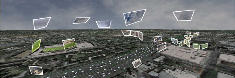
We introduce methods for augmenting aerial visualizations of Earth (from tools such as Google Earth or Microsoft Virtual Earth) with dynamic information obtained from videos. Our goal is to make Augmented Earth Maps that visualize the live broadcast of dynamic sceneries within a city. We propose different approaches to analyze videos of pedestrians and cars, under differing conditions and then augment Aerial Earth Maps (AEMs) with live and dynamic information. We also analyze natural phenomenon (clouds) and project information from these to the AEMs to add the visual reality.
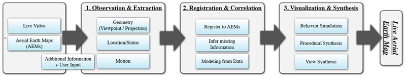
System Overview

Videos

(1) AVI/Divx 6.8, 80MB: Download

(2) Youtube (5:21) :

https://scanable.com/wp-content/uploads/2025/01/SCANable_logo_emblemSimple-180x180.png 0 0 Travis Reinke https://scanable.com/wp-content/uploads/2025/01/SCANable_logo_emblemSimple-180x180.png Travis Reinke2009-09-30 14:45:322009-09-30 14:45:32Augmenting Aerial Earth Maps with Dynamic Information

REVIEW: Leica Geosystems ScanStation C10 and Cyclone 7

September 3, 2009/0 Comments/in 3D Laser Scanning, Modeling, New Technology, Point Cloud, Reviews/by Travis Reinke

On Sepember 1, 2009, Leica Geosystems and Point of Beginning Magazine hosted a webinar titled The Business of Laser Scanning — hype or competitive advantage? Presenters Michael Harvey and Frank Hahnel along with Kristi Grahl discussed using laser scanning technology to:

  • Submit more competitive bids — and win more jobs — for both high-end projects and routine surveys.
  • Meet the requirements of customers who increasingly incorporate HDS into their project specifications.
  • Lower your labor costs and increase profit margins on every job.
  • Increase customer satisfaction with more accurate and detailed surveying reports.

During the webinar, the presenters also announced the availability of Leica’s new ScanStation C10 self-contained time-of-flight 3D laser scanner along with Cyclone 7, Cloudworx for SmartPlant3D and Forensic Map.

Some of the benefits of the new ScanStation C10:

  • No cables
  • On-board data storage
  • USB Interface for data transfer
  • Uses Internal Lithium-Ion TPS Total Station Batteries
    • Hot-swappable
    • 3.5 – 4 hours per battery
    • 4 come with scanner
  • GPS antenna and prism mount attachements
  • Automatically switches between oscillate/spin mirror mode to improve speed
  • Can still be used with a laptop
  • 180-degree sweep – scans both sides
  • Higher resolution capability
  • Integrated color touch-screen
  • Light-weight – 28.6 lbs (scanner),
  • More Portable – 62 lbs (scanner in case)
  • Dual High-resolution camera/video with auto exposure and auto focus
    • Faster target acquisition by point and shoot using the on-board color touch screen
    • Acquire full dome images in 4-7 minutes
  • Man Machine Interface (MMI)
    • Similar to Leica TPS Total Stations
  • Shorter Start-up time
  • Low scan power
  • Withstands moisture better than ScanStation 2

Cyclone 7 Features:

  • Updated Traverse Editor
  • Improved meshing capabilities
    • Leica acquired 3Dreshaper – new meshing functionality
    • Meshing of tunnels
  • Point Cloud engine is real-time indexed – faster viewing performance

View this webcast on-demand. The archive will be available for one year from the live broadcast.

Request your FREE on-site demo — Want to see the new ScanStation c10 in action? Reserve your spot at www.leica-geosystems.us/c10.

https://scanable.com/wp-content/uploads/2025/01/SCANable_logo_emblemSimple-180x180.png 0 0 Travis Reinke https://scanable.com/wp-content/uploads/2025/01/SCANable_logo_emblemSimple-180x180.png Travis Reinke2009-09-03 12:17:522009-09-03 12:17:52REVIEW: Leica Geosystems ScanStation C10 and Cyclone 7

Leica Announces New ScanStation C10 Laser Scanner

September 1, 2009/0 Comments/in 3D Laser Scanning, In the News, New Technology/by Travis Reinke

Leica ScanStation C10

The All-in-One Laser Scanner for Any Application

Today’s most popular class of laser scanner – ScanStation™ – is now in a compact, all-in-one ScanStation C10 platform. It includes scanner, tilt sensor, battery, controller, data storage, auto-adjusting video camera and laser plummet. ScanStation C10 also features major productivity advances, including a new Smart X-Mirror™ that lets users conduct full-dome scans in literally just minutes using a spinning mirror.

With outstanding performance for site, exterior, and interior applications, ScanStation C10 makes High-Definition Surveying™ (HDS™) profitable for even more as-built, topographic and monitoring surveys. The ScanStation C10 platform represents the most capabilities and best value packed into a single laser scanner instrument. Users can take advantage of surveyor-friendly, onboard total station-like control or use an external laptop for even more powerful, onsite viewing and data processing.

ScanStation C10 combines all-in-one portability with the ability of users to traverse, resection or use scan targets for maximum flexibility in dealing with site logistics. Full 360º x 270º field-of-view, high accuracy, long range (300m @90% reflectivity), and high scan speed (50k pts/sec) add to ScanStation C10’s position as the industry’s most versatile scanner.

Major Productivity Advances
ScanStation is faster than its predecessor ScanSation 2 in many ways. It does full dome scans up to 10X faster – now, less than 2 minutes for a typical room. It also conducts general 360º and focused areas scans faster, can be setup & moved faster, lets users locate targets, register & geo-reference faster, and lets users check scan results faster.

Valuable Cost Savings
ScanStation is easy to learn, with a total station-like interface and intuitive, onboard graphic color touch screen display. It is also incrementally upgradeable over time, uses standard total station batteries, and features fewer accessories – all of this contributes to a reduced cost of ownership.

All-in-One Construction

Familiar, total station-like interface
Leica ScanStation C10 supports standard field workflows with a rich, familiar total station interface. Easy to learn touch screen operation.
Integrated real-time streaming video with zoom
For fast, accurate selection of scene and targets to be scanned. The auto-adjusting, internal, high-resolution camera image can also be used for texture mapping of point clouds.
Smart X-Mirror™ design
The mirror automatically spins for fast 360º and full dome scans and oscillates for efficient, targeted scans. The same Smart X-Mirror automatically aligns the internal camera image for fast, accurate texture mapping of point clouds.
Compatibility with standard surveying equipment
Attach handles with Leica GPS SmartAntenna or prism holder, or use without handle for unobstructed overhead scans. A built-in laser plummet and tribrach mount provide added compatibility with standard field procedures and accessories.

https://scanable.com/wp-content/uploads/2025/01/SCANable_logo_emblemSimple-180x180.png 0 0 Travis Reinke https://scanable.com/wp-content/uploads/2025/01/SCANable_logo_emblemSimple-180x180.png Travis Reinke2009-09-01 09:51:372009-09-01 09:51:37Leica Announces New ScanStation C10 Laser Scanner

Technology of the Future – Where Microsoft Thinks We Will Be by 2019

August 24, 2009/0 Comments/in In the News, New Technology/by Travis Reinke

Technology is a wonderful thing… when it works. I am always fascinated by the rapid speed in which technology is advancing. Augmented reality, intelligent models, holographs, etc. are no longer things of the future, but technology of today. That said, I wanted to share this video showing what technology Microsoft Research expects to exist by the year 2019 – a miniscual ten years from now.

https://scanable.com/wp-content/uploads/2025/01/SCANable_logo_emblemSimple-180x180.png 0 0 Travis Reinke https://scanable.com/wp-content/uploads/2025/01/SCANable_logo_emblemSimple-180x180.png Travis Reinke2009-08-24 13:26:512009-08-24 13:26:51Technology of the Future – Where Microsoft Thinks We Will Be by 2019

3D Laser Mapping/Riegl Brings World’s Fastest, Lightest Laser Scanner to the UK

June 13, 2009/0 Comments/in 3D Laser Scanning, New Hardware, New Technology/by Travis Reinke

Nottingham, UK – 3D Laser Mapping has announced the UK launch of the world’s fastest and lightest mobile laser scanner. Designed to instantly 3D map buildings, infrastructure and highways to 5mm accuracy within half a kilometre, the Riegl VZ-400 represents a new generation of laser scanner technology. Weighing just 10kg and carried in a handy rugged briefcase, the added portability, accuracy and speed is set to revolutionise 3D field mapping.

Part of the Riegl V-Line range the VZ-400 utilises unique echo digitisation to achieve superior performance and accuracies of measurement, even under adverse weather conditions. The evaluation of multiple targets combined with a reliable, robust and lightweight construction makes the VZ-400 ideally suited to civil engineering, city modelling and architectural projects.

The Riegl VZ-400 is part of the newly released V-Line Range. The first to offer Online Waveform Analysis and Echo Digitisation the Riegl V-Line Laser Scanners enable measurement of multiple targets, with improved accuracy for distance measurements, combined with very high measurement and scanning rates and output of a quality indicator for each measurement.

“The results from these field trials prove the performance and capability of the VZ-400 laser scanner,” commented Dr Graham Hunter, Managing Director of 3D Laser Mapping. “Even under the harshest operating conditions the VZ-400 captures very high accuracy measurements, at speed and with a level of quality no seen before.”

Riegl has over thirty years experience in the research, development and production of laser rangefinders, distancemeters and scanners. Primarily a technology company Riegl specialise in producing technically innovative solutions for specific applications working in partnership with organisations such as 3D Laser Mapping to produce powerful turnkey solutions for multiple fields of application.

A Riegl Premier Distributor, 3D Laser Mapping is a global developer of laser scanning solutions for sectors such as mapping, mining and manufacturing. 3D Laser Mapping specialises in integrating laser scanning hardware with their own software and peripherals to create solutions at the cutting edge of technology.

https://scanable.com/wp-content/uploads/2025/01/SCANable_logo_emblemSimple-180x180.png 0 0 Travis Reinke https://scanable.com/wp-content/uploads/2025/01/SCANable_logo_emblemSimple-180x180.png Travis Reinke2009-06-13 19:39:412009-06-13 19:39:413D Laser Mapping/Riegl Brings World’s Fastest, Lightest Laser Scanner to the UK
Page 4 of 41234

Pages

  • 2023 Trilith Charity Gala
  • 3D Body Scanning, LiDAR and VFX Support in Houston, Texas
  • 3D Head and Body Scanning
  • 3D Object Scanning
  • 3D Scanning & VFX Capture in Los Angeles
  • 3D Scanning & VFX Capture in Texas | SCANable
  • 3D Scanning, Drone Photogrammetry & LiDAR in Atlanta | SCANable
  • 3D Scanning, Drone Photogrammetry & LiDAR in New York City | SCANable
  • 3D VFX LiDAR Scanning and Support in New Orleans, Louisiana
  • 3D VFX Scanning and Support in Atlanta, Georgia
  • 3D VFX Scanning and Support in Los Angeles, California
  • 3D VFX Scanning and Support in New York
  • About Us
  • Architecture & Heritage
  • Artec Leo
  • Asset
  • Awards
  • Blog
  • C.A.L.V.I.N.N.™ Camera Array for Lightfields, Volumetrics, Imaging, and Neural Networks
  • Cart
  • Checkout
  • Civil/Survey
  • Clients
  • Contact
  • Drone Photogrammetry
  • FARO Focus S 150 and 350 3D Laser Scanner
  • FARO Focus3D X 330 Long Range 3D Laser Scanner
  • FARO Freestyle3D Handheld Scanner
  • Home
  • Industry News
  • Leica HDS6200
  • LiDAR Location and Environment 3D Scanning
  • Logout
  • Maquette, Statues and Fine Art 3D scanning
  • Mobile 3D Scanning
  • Mobile Photogrammetry Studios
  • MoPho 1 Service Request
  • MoPho 2 Service Request
  • MoPho 3 Service Request
  • My Account
  • New
  • News
  • Plant, Process & Marine
  • Pricing and FAQ
  • Privacy Policy
  • Purchase Affordable 3D Laser Scanners
  • Recent Productions
  • Rent the Leica RTC360
  • Request 3D Scanning Services
  • SCANable Rig Checklist
  • SCANable UAS (Unmanned Aerial Systems)
  • SCANable | COVID-19 Response
  • Security and Threat Analysis
  • Services
  • Shop
  • Surphaser 100HSX
  • Trailer Move
  • Training and Support
  • VFX 3D Vehicle Scanning For Film and Television
  • VFX is not AI
  • Virtual Reality
  • Visual Effects/CGI

Categories

  • 3D Laser Scanning
  • 3D Printing
  • Animation
  • Archaeology
  • Blog
  • Building Information Modeling (BIM)
  • Events
  • Featured
  • Forensic
  • Government
  • In the News
  • Industrial
  • Industry
  • LiDAR
  • Mobile Scanning
  • Modeling
  • New Hardware
  • New Technology
  • News
  • Photogrammetry
  • Point Cloud
  • Reviews
  • Software
  • Uncategorized
  • Virtual Reality
  • Visual Effects (VFX)

Archive

  • June 2025
  • May 2025
  • January 2025
  • December 2024
  • November 2022
  • October 2020
  • August 2020
  • July 2020
  • June 2020
  • January 2020
  • July 2017
  • May 2017
  • April 2017
  • December 2016
  • November 2016
  • October 2016
  • September 2016
  • July 2016
  • May 2016
  • March 2016
  • September 2015
  • June 2015
  • May 2015
  • March 2015
  • January 2015
  • December 2014
  • November 2014
  • August 2014
  • June 2014
  • April 2014
  • March 2014
  • February 2014
  • January 2014
  • November 2013
  • June 2013
  • March 2013
  • January 2013
  • December 2012
  • November 2012
  • September 2012
  • August 2012
  • July 2012
  • December 2010
  • November 2010
  • October 2010
  • August 2010
  • May 2010
  • April 2010
  • March 2010
  • February 2010
  • January 2010
  • December 2009
  • November 2009
  • October 2009
  • September 2009
  • August 2009
  • July 2009
  • June 2009
  • May 2009

Quick Pages

  • Home
  • News
  • Services
  • Contact
  • Privacy Policy

Recent Productions

  • Play Dirty (Prime Video)
  • Peacemaker (DC Studios)
  • Marty Supreme (A24)
  • Superman (DC Studios)
  • Happy Gilmore 2 (Netflix)

Categories

  • 3D Laser Scanning
  • 3D Printing
  • Animation
  • Archaeology
  • Blog
  • Building Information Modeling (BIM)
  • Events
  • Featured
  • Forensic
  • Government
  • In the News
  • Industrial
  • Industry
  • LiDAR
  • Mobile Scanning
  • Modeling
  • New Hardware
  • New Technology
  • News
  • Photogrammetry
  • Point Cloud
  • Reviews
  • Software
  • Uncategorized
  • Virtual Reality
  • Visual Effects (VFX)

Locations

Georgia

Los Angeles

New York

Houston

New Orleans

© Copyright 2026 - SCANable - Enfold Theme by Kriesi
  • Link to Facebook
  • Link to X
  • Link to LinkedIn
  • Link to Youtube
  • Link to Rss this site
  • Link to Instagram
Scroll to top Scroll to top Scroll to top