Create Floor Plans Automatically from 3D Point Clouds [Point-Cab]

SCANable is evaluating this promising new software and will follow-up with an indepth review in the coming days. In the meantime, please feel free to check it out for yourself and leave your input here.

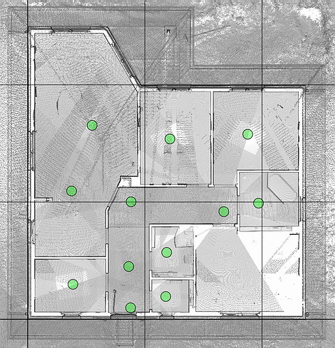
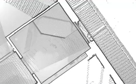
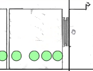
Automatic analysis and interpretation of laser scanning data

  • Floor plans, views and sectional views are created at the push of a button.
  • Program offers an intuitive user interface (no training required).
  • For the first time, results can be processed in almost all CAD programs.
  • Visual representations allow a direct use and will dramatically reduce time needed for analysis and modeling.


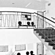
Point-Cab is the first application that automatically creates―at the push of a button―floor plans and sectional views. The goal of the development team has been to create an extremely user-friendly interface design.

The program creates a visual representation of laser scanning data. The result has much more expressiveness and validity than individual points of point clouds. Images and representations of sections are a prerequisite for an easy modeling in CAD programs.

The program supports most of the common CAD programs and construction tools through standard interfaces. You may use the results in ArchiCAD, Google SketchUp, Revit and other tools.

Point-Cab product videos

Get to the video:

Creation of a floor plan at the push of a button

Get to the video:

Sectional views created from laser scanning data

Point-Cab supports several CAD programs, such as:

    • AutoCAD
    • ArchiCAD
    • Microstation
    • SketchUp

Point-Cab Layout supports the following laser scanner formats:

    • PTX exchange format
    • FARO laser scanner
    • Riegl laser scanner (available soon)
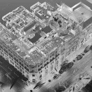
Examples of use

Point-Cab Layout transfers laser scanning data into AutoCAD (available soon)

Point-Cab transfers laser scanning data into ArchiCAD (available soon)

Point-Cab transfers laser scanning data into Microstation (available soon)

Point-Cab transfers laser scanning data into SketchUp

Point-Cab Layout trial version

Find out for yourself why this revolutionary program can make such a difference for you.Click here to download the Point-Cab trial version. The trial version can be used for 15 hours. Time is consumed when you use the application. Feel free to also download our laser scanning data examples. Please find all data examples here.

Here you can download the processed layout results of the full version of Point-Cab.

Buy Point-Cab Layout

Click here or send email to info@laserscanning-europe.com.

Digitally Preserving American History

Erosion from recent storms uncovered the wreck by Harry R. Feldman Inc.

It is great to finally see people accepting the benefits of laser scanning as a means of digital preservation. Below is an excellent article posted by by Stefanie Geisler, Boston Globe Correspondent. Source

The wreck of the British warship that Paul Revere slipped by on his legendary journey to Lexington in 1775 has resurfaced in the shifting sands of Cape Cod, and federal park officials are seizing the moment by having the wreck “digitally preserved,” using three-dimensional imaging technology.

“We know the wreck is going to disappear again under the sand, and it may not resurface again in our lifetimes,” said William P. Burke, the historian at the Cape Cod National Seashore, noting that the last time any part of the HMS Somerset III had been sighted was 37 years ago.

“Somewhere down the road, if someone’s researching the Somerset, or the effects of ocean currents on shipwrecks, or anything like that, they will have this record,” he said. “We’re in the forever business. We’re looking at tomorrow, but we’re also looking ahead indefinitely.”

The Somerset fought in the American Revolution and had a crew of more than 400. In 1775, Paul Revere slipped through Boston Harbor past the ship before beginning his ride to warn the colonials the British were on the move. In his poem “Paul Revere’s Ride,” Henry Wadsworth Longfellow called it “a phantom ship, with each mast and spar/Across the moon like a prison bar.” The ship sank on Nov. 2, 1778 off the Cape.

After erosion from recent storms, about a dozen of the Somerset’s timbers were found poking through the wet sand at low tide in the national seashore in Provincetown. Park officials called on Harry R. Feldman Inc., a land surveying company from Boston, to make the three-dimensional rendering.

On Thursday, crews set up survey markers and a laser scanning instrument, said Michael Feldman, the company’s president.

The instrument was placed near the timbers, Feldman said. Using the scanner, the surveyors collect millions of data points that are used to create the three-dimensional rendering.

“The great thing about this technology is it not only shows a three-dimensional picture or video of what’s there, it also obtains data down to quarter-inch accuracy,” Feldman said.

It could take several visits to the site to complete the imaging. But when it’s done, the national seashore will have an animated fly-through of the wreck site — and anyone interested in seeing it won’t have to wait for the timbers to reappear.

The imaging will only capture the timbers that are showing. The rest of the wreck, which is buried in sand, might deteriorate if the site were excavated, Burke said.

Most of the crew survived when the ship sank, but they didn’t get a warm welcome when they reached the shore, he said.

“They were pretty upset with them, because the British had been blockading Provincetown for a long time during the war,” Burke said. “They marched all the survivors off the Cape, and eventually exchanged them for American prisoners.”

Intelisum receives U.S. Patent for GPS-Enhanced Laser Scanning System

On March 30,2010, Intelisum Inc. received a U.S. Patent for “GPS-enhanced system and method for automatically capturing and co-registering virtual models of a site”. According to the United States Patent and Trademark Office website, this was originally filed on June 30, 2006. Details on the filing are listed below and the filing can be found here.

BACKGROUND

1. Field of the Invention

The present invention relates generally to three-dimensional modeling. More specifically, the present invention relates to a system and method for capturing three-dimensional virtual models of a site that can be co-registered and visualized within a computer system.

2. Description of Related Background Art

Lidar (light detection and ranging) uses laser technology to make precise distance measurements over long or short distances. One application of lidar is the range scanner, or scanning lidar. In a typical range scanner, a lidar is mounted on a tripod equipped with a servo mechanism that continuously pans and tilts the lidar to scan a three-dimensional area. During the scanning process, the lidar makes repeated range measurements to objects in its path. The resulting range data may be collected and serve as a rough model of the scanned area.

Physical limitations of the range scanner constrain the maximum resolution of the range data, which decreases with distance from the range scanner. At large distances, the range scanner may not be able to discern surface details of an object. A lack of continuous spatial data (gaps between points) and a lack of color attributes are significant limitations of conventional range scanners. Furthermore, a range scanner only scans objects within the lidar’s line-of-sight. As a result, no data is collected for the side of an object opposite to the lidar or for objects obscured by other objects (“occlusions”).

To obtain a more complete and accurate model, the range scanner can be moved to other scanning locations in order to scan the same area from different perspectives and thereby obtain range data for obscured objects. Thereafter, the resulting sets of range data can be merged into a single model.

Unfortunately, the merging of sets of range data is not automatic. Human decision-making is generally required at several steps in the merging process. For instance, a human surveyor is typically needed to determine the relative distances between the range scanning locations and the scanned area. Furthermore, a human operator must manually identify points in common (“fiducials”) between multiple sets of range data in order to align and merge the sets into a single model. Such identification is by no means easy, particularly in the case of curved surfaces. The need for human decision-making increases the cost of modeling and the likelihood of error in the process.

SUMMARY OF THE INVENTION

A system for capturing a virtual model of a site includes a range scanner for scanning the site to generate range data indicating distances from the range scanner to real-world objects. The system also includes a global positioning system (GPS) receiver coupled to the range scanner for acquiring GPS data for the range scanner at a scanning location. In addition, the system includes a communication interface for outputting a virtual model comprising the range data and the GPS data.

The system may further include a transformation module for using the GPS data with orientation information, such as bearing, for the range scanner to automatically transform the range data from a scanning coordinate system to a modeling coordinate system, where the modeling coordinate system is independent of the scanning location. A co-registration module may then combine the transformed range data with a second set of transformed range data for the same site generated at a second scanning location.

The system also includes a digital camera coupled to the range scanner for obtaining digital images of the real-world objects scanned by the range scanner. The system may associate the digital images of the real-world objects with the corresponding range data in the virtual model.

A system for building a virtual model of a site includes a communication interface for receiving a first set of range data indicating distances from a range scanner at a first location to real-world objects. The communication interface also receives a first set of GPS data for the range scanner at the first location. The system further includes a transformation module for using the first set of GPS data with orientation information for the range scanner to automatically transform the first set of range data from a first local coordinate system to a modeling coordinate system.

A system for modeling an object includes a range scanner for scanning an object from a first vantage point to generate a first range image. The system further includes a GPS receiver for obtaining GPS readings for the first vantage point, as well as a storage medium for associating the first range image and the GPS readings within a first virtual model.

The range scanner may re-scan the object from a second vantage point to generate a second range image. Likewise, the GPS receiver may acquire updated GPS readings for the second vantage point, after which the storage medium associates the second range image and the updated GPS readings within a second virtual model. A transformation module then employs the GPS readings of the virtual models with orientation information for the range scanner at each location to automatically transform the associated range images from local coordinate systems referenced to the vantage points to a single coordinate system independent of the vantage points.

Autodesk Expands Power of AutoCAD 2011 with New Point Cloud Support

SAN RAFAEL, Calif.–(BUSINESS WIRE)–Autodesk, Inc. (NASDAQ:ADSK) announced the availability of the 2011 AutoCAD software products, including AutoCAD 2011 software, a leading 2D and 3D design and documentation platform, and AutoCAD LT 2011 software for professional 2D drafting and detailing. The latest releases of AutoCAD deliver powerful new features — such as new tools for surface modeling and transparency for objects and layers — that can help designers explore their ideas and maximize productivity. The 2011 AutoCAD products are Microsoft Windows 7 certified and are compatible with and supported on Windows 7 Home Premium, Professional, Enterprise, and Ultimate as well as Windows Vista and Windows XP operating systems.

“We have also implemented many of the top features requested by Autodesk User Group International (AUGI) members and focused on providing new tools that are quick to learn but can have a big impact in everyday work.”

“In the 2011 releases we have continued to invest in increasing drafting productivity and have added a strong set of new 3D modeling features for conceptual design that will help millions of AutoCAD users worldwide take their designs further,” said Guri Stark, vice president, AutoCAD and Platform Products. “We have also implemented many of the top features requested by Autodesk User Group International (AUGI) members and focused on providing new tools that are quick to learn but can have a big impact in everyday work.”

AutoCAD 2011 gives designers more advanced conceptual design tools as well as increased flexibility and control when designing in 3D:

  • New surface modeling tools enable users to easily create smooth surfaces and surface transitions, while associativity maintains relationships between all of the objects.
  • Point cloud support for up to two billion points enables users to quickly visualize scanned objects directly within the modeling workspace.
  • Inferred constraints enable designers to define constraints as they draw.
  • Hatch command enhancements bring improved drafting efficiency, while new gradient hatch patterns enable users to add more colors and shading to drawings.
  • TimeSaver tools, previously available only to customers on Autodesk Subscription, are now available to all AutoCAD users.

AutoCAD LT 2011 builds on its reputation for productivity with new commands that make everyday tasks more efficient. In addition to the hatch command enhancements and TimeSaver Tools found in AutoCAD 2011, AutoCAD LT 2011 adds new tools that give users additional options for controlling the appearance of drawings:

  • Transparency for objects and layers provides new options for managing the appearance of drawings and communicating design intent.
  • New multifunctional polyline grips make editing polylines significantly faster and easier.
  • The ability to create or select similar objects based on the properties of existing objects helps users save time when drawing and editing geometry.

Industry Solutions for the AutoCAD 2011 Products

The updated AutoCAD 2011 software portfolio includes the following industry-specific applications built on the AutoCAD platform:

  • AutoCAD Architecture 2011 software for efficient architectural drafting and documentation has new geometric and dimensional constraints and renovation tools to help accelerate design.
  • AutoCAD Electrical 2011 software helps electrical controls designers to quickly create control system designs and easily access extensive catalog information for large electrical controls projects.
  • AutoCAD Mechanical 2011 software’s streamlined design environment gives users vastly improved access to power dimensioning functionality, which automatically aligns part dimensions with the rest of the drawing properties, without ever opening a dialog box.
  • AutoCAD MEP 2011 software provides greater drafting productivity for mechanical, electrical and plumbing (MEP) designers and drafters and has new features for creating and storing AutoCAD block names, sloped piping and parallel conduit routing.

Availability

Product availability varies by country. Details and purchasing options are available at www.autodesk.com/purchaseoptions.

About Autodesk

Autodesk, Inc., is a world leader in 2D and 3D design, engineering and entertainment software for the manufacturing, building and construction, and media and entertainment markets. Since its introduction of AutoCAD software in 1982, Autodesk continues to develop the broadest portfolio of state-of-the-art software to help customers experience their ideas digitally before they are built. Fortune 100 companies — as well as the last 15 Academy Award winners for Best Visual Effects — use Autodesk software tools to design, visualize and simulate their ideas to save time and money, enhance quality and foster innovation for competitive advantage. For additional information about Autodesk, visit www.autodesk.com.

Autodesk, AutoCAD and AutoCAD LT are registered trademarks or trademarks of Autodesk, Inc., and/or its subsidiaries and/or affiliates in the USA and/or other countries. Academy Award is a registered trademark of the Academy of Motion Picture Arts and Sciences. All other brand names, product names or trademarks belong to their respective holders. Autodesk reserves the right to alter product and services offerings, and specifications and pricing at any time without notice, and is not responsible for typographical or graphical errors that may appear in this document.

© 2010 Autodesk, Inc. All rights reserved.

IBM Visualizes a “Smarter Planet” using 3D Laser Scanning Technology [LiDAR]

HOUSTON, TX March 18, 2010 Coign Asset Metrics & Technologies (CoignAMT), at the direction of Zoo Film Productions of Hollywood, CA, has helped produce IBM’s first globally released television commercial created entirely from Light Detection and Ranging (LiDAR) 3D point cloud data.

CoignAMT used the HDS6100 phase-based laser scanner from Leica Geosystems to create scenes of cars on a freeway, patients in a hospital, electricity grids and much more. The 30-second LiDAR-based commercial is a key part of IBM’s Smarter Planet initiative to portray that data is all around; and that by changing the way the world thinks, companies can maximize the use of data to lower their costs and reduce environmental impact.

Travis Reinke, business sector manager for CoignAMT, says, “Coincidentally, IBM’s perspective is a core part of CoignAMT’s business practice. We help our clients see the long-term value of the data they currently have by using the latest technology, such as 3D laser scanning, to quickly gather an immense amount of data to support their existing “intelligent” systems.”

The Zoo Film Productions crew spent a week in Houston, TX with CoignAMT personnel capturing laser scan data of transmission lines and over 16 blocks of downtown Houston streetscape and surounding buildings. CoignAMT then merged the point cloud data gathered in downtown with 6 square miles of low-altitude helicopter-based LiDAR provided by Aerotec LLC out of Birmingham, AL. Zoo Film Productions crews also created numerous scenes of hospital activities as well as automobiles with and without drivers that CoignAMT scanned individually for use in the commercial.

Reinke continues, “We were honored to be part of this innovative project given the direct correlation between the services CoignAMT provides and IBM’s Smarter Planet initiatives. Using the latest laser scanning technology to visually portray the importance of the data surrounding us was an unforeseen irony. I would never have imagined that we would be using this technology to scan people and cars, objects that are often considered ‘noise’ on a typical inventory project.”

View IBM “Data Anthem” at 848×480: http://www.glossyinc.com/zoo/ibmdataanthem.html
Full credits and a selection of stills: http://www.glossyinc.com/ibmdacred.html
Follow CoignAMT on Twitter: http://www.twitter.com/CoignAMT
Follow Travis Reinke on Twitter: http://www.twitter.com/HDLS

YouTube: http://www.youtube.com/watch?v=3cj6VtYpBI4

# # #

About Coign Asset Metrics & Technologies LLC:
Coign Asset Metrics & Technologies, LLC (CoignAMT) is a HUBZone qualified, SBA certified, small business that provides a full range of asset management life cycle services and specialized technologies, including high definition laser scanning (HDLS). Its mission is to strengthen public and private sector organizations by aligning their assets and operational practices with their strategic initiatives. CoignAMT is headquartered in the Pittsburgh, PA area, with regional offices located in Colorado Springs, CO, and Houston, TX. Clients include federal, state, and local governments, as well as private sector customers in the construction, energy, transportation, manufacturing, and security industries.

Boeing Launches Compact 3-D Imaging Camera

ALBUQUERQUE, N.M., March 8, 2010 — The Boeing Company [NYSE: BA] today announced it has begun offering a new, compact, energy-efficient camera that provides three-dimensional images for military and commercial applications.

Boeing Directed Energy Systems and wholly owned Boeing subsidiary Spectrolab have jointly developed the camera using their own research and development funding, and successfully tested it over the past two years by attaching it to mobile ground platforms and a Boeing AH-6 Little Bird helicopter. Equipped with advanced sensors that were developed by the Massachusetts Institute of Technology’s Lincoln Laboratory and transferred to Boeing under a teaming arrangement, the cube-shaped camera is one-third the size and uses one-tenth the power of most comparable 3-D imaging cameras.

“Our three-dimensional camera fits a lot of capability into a small package,” said Nasser Karam, vice president of Advanced Technology Products at Spectrolab. “Its compact design and modest power needs will allow it to be deployed on a wide range of platforms, including unmanned aerial and ground vehicles that don’t have much room or power to spare.”

The camera, which Boeing can customize for each customer, has many potential uses, including mapping terrain, tracking targets and seeing through foliage. To create a 3-D image, the camera fires a short pulse of laser light, then measures the pulse’s flight time to determine how far away each part of the camera’s field of view is.

“The camera combines cutting-edge sensor technology with Boeing’s advanced pointing and tracking solutions and real-time processing to provide our customers with highly integrated 3-D imaging payloads for ground, airborne or space-based applications,” said Joseph Paranto, Growth lead for Directed Energy Systems in Albuquerque.

Boeing is currently integrating the camera into compact 3-D imaging payloads on unmanned aerial vehicles and will be testing that capability this spring. The team will also add 3-D video capability to the camera soon to complement its existing still-image capability.

A unit of The Boeing Company, Boeing Defense, Space & Security is one of the world’s largest defense, space and security businesses specializing in innovative and capabilities-driven customer solutions, and the world’s largest and most versatile manufacturer of military aircraft. Headquartered in St. Louis, Boeing Defense, Space & Security is a $34 billion business with 68,000 employees worldwide.

Source: http://boeing.mediaroom.com/index.php?s=43&item=1107

Bentley Announces Integration of Pointools

Bentley Announces Point Cloud Integration using PointoolsPresented by: Executives from Spar Point research, Pointools, and Bentley

Summary:On October 14, 2009, Bentley announced that it had signed a “Continuous Technology Transfer Agreement” to incorporate Pointools’ Vortex Engine in the Bentley Technology Platform to enable reuse of 3D laser scanned data. This webinar will include three different perspectives on this agreement. To see the future of 3D data integration and platform interoperability you have to attend this webinar.

What you can learn:

  • An overview by Spar Point Research of the impact that laser scanning technology is having on the design, construction, and management of industrial plant, BIM, and civil/transportation infrastructure assets
  • The importance of integrating this technology into the daily workflows of infrastructure professionals and the value users will realize from this integration
  • A brief demonstration by Pointools of the Vortex engine functionality including an explanation on why the Pointools’ technology is so fast and so capable of handling billions of point clouds at one time
  • Watch this eSeminar by chapter:
    These videos open directly into your media player.

    Resources:

    Diversified Business Communications Acquires Spar Point Research

    Spar Point Research LLC has been acquired by Diversified Business Communications, a U.S.-based trade show, publishing and eMedia company headquartered in Portland, Maine.
    Tom Greaves, founder of Spar Point Research, will join the Diversified management team as managing director of the Spar Point Group. “We are excited about the future growth opportunities for Spar Point Group as part of Diversified,” Greaves said. “Diversified is a leading media and trade show organization with global reach and a proven record of strengthening the industries it serves. Diversified’s resources will allow our team to expand our geographic reach more quickly and better serve the needs of users and suppliers of 3D imaging technologies worldwide.“

    “Diversified is actively looking for opportunities to partner and acquire emerging industry franchises,” said Nancy Hasselback, president and CEO of Diversified Communications. “We see a tremendous opportunity for growth in 3D imaging technology.”

    “The Spar Point Group products are a great addition to our portfolio,” commented Mike Lodato, group vice president, who will be responsible for the corporate leadership of the Spar Point Group portfolio. “I look forward to working with Tom and the rest of the team to expand this franchise and leverage his expertise.”

    Spar Point Research LLC, a Massachusetts-based company, has organized SPAR conferences in the United States and Japan since 2003. SPAR 2010 will be held Feb. 8-10, 2010 in Houston, Texas, USA. SPAR 2010J will be held April 15-16, 2010 in Kawasaki, Japan. The company also publishes SparView, an electronic newsletter serving more than 12,000 readers from engineering, construction, manufacturing, law enforcement and security planning organizations worldwide.

    Diversified Business Communications provides information and market access through trade exhibitions, magazine publishing and eMedia products on four continents. Diversified serves a number of industries including seafood, food service, natural and organic products, commercial marine, integrative health care, oil and gas, and business management. Diversified operates divisions in Australia, Canada, Hong Kong, India and the UK. For more information, visit www.divbusiness.com.

    Investigators get 3-D crime scanner

    crime_scene_mgmt1_2405By Guillermo X. Garcia Express-News

    Bexar County’s criminal investigators soon will have cutting-edge help as they comb through crime scenes: a 3-D, computerized laser scanning system.

    County commissioners approved the $207,000 purchase Tuesday.

    “This is state-of-the-art equipment,” said Jose Treviño, the Sheriff’s Office homicide supervisor. “This will provide much more accurate data, and much quicker, to investigators at the scene.”

    The system, which will be operational by March, takes a 3-D electronic photograph that plots objects in a 360-degree scan.

    The unit “will all but eliminate human error” when it comes to measuring and plotting crime scene evidence, Treviño said.

    “Eliminating the human error means you’ll have much greater chance that evidence won’t be missed,” he added. “It also guarantees much more accuracy in documenting the evidence’s location.”

    Law enforcement officials say they plan to use the tool to probe major incidents, such as bank robberies, homicides and large-scale traffic accidents.

    The Leica Geosystems scanner the county is purchasing is similar to but newer than scanners used at Fort Hood to gather evidence in the shooting massacre that killed 13 people last month. A similar device also was used to reconstruct the Interstate 35 bridge collapse in Minneapolis in August 2007.

    Under a regional contract, surrounding counties and municipalities also will have access to the equipment, said Sheriff Amadeo Ortiz.

    In other business, the commissioners were briefed on a project that will allow county residents to electronically request and track work orders for repairs to roads, sidewalks, bridges, signs and drainage structures.

    Once operational, residents can access the Public Works Citizens Request Portal to create an electronic work request. The system also will provide status reports on all pending projects on a given street or in a neighborhood, said County Engineer Renee Green.

    She said the public will be able to access the program starting Jan. 4.

    graphic

    3D mapping drone fires lasers from a mile away (video)

    by Vladislav Savov @ Engadget posted Nov 18th 2009 at 6:40AM

    The MIT Technology Review has unearthed a new laser-based 3D mapping robot that can produce results similar to those obtained from $100,000 systems at about a fifth of the cost. Funded by the US Army, researchers at the Stevens Institute of Technology have now demonstrated the Remotely Operated and Autonomous Mapping System (ROAMS, for short), which employs a mirror-based LIDAR system that bounces a laser off a rapidly rotating mirror and gleans environmental information from how long it takes for each pulse to bounce back. An array of video cameras and IR proximity sensors add to this recon bot‘s sentience, though you’ll still need to be within a mile’s range to operate it. So not quite yet ready for solo missions to Mars, but plenty useful for gathering data on our own planet. You’ll find video and imagery of the results this machine kicks out after the break.