3D Systems buys company behind Star Wars, Hobbit and Harry Potter models

3D Systems Acquires Gentle Giant Studios

  • Accesses decades of licensed content from industry’s greatest brands
  • Expands leadership capabilities and know-how in retail merchandising
Release Date:
Friday, January 3, 2014 – 08:36

ROCK HILL, South Carolina – January 3, 2014 – 3D Systems  (NYSE:DDD) announced today the acquisition of Gentle Giant Studios, the leading provider of 3D modeling for the entertainment and toy industry. For over two decades, Gentle Giant Studios has led the development of state-of-the-art content using 3D scanning and modeling to develop and manufacture licensed 3D printed characters, toys and collectibles from a variety of franchise properties with global brand recognition, including Marvel, Disney, AMC’s The Walking Dead, Avatar, Harry Potter and Star Wars.

3DS plans to immediately leverage Gentle Giant Studios technology and vast library of digital content into its consumer platform and extend its existing brand relationships to further the reach of 3D scanning, modeling and printing for entertainment, toys, collectibles, action figures in conjunction with numerous blockbuster films and evergreen licensed properties.

“Gentle Giant Studios catapults 3DS’s consumer platform forward with highly curated, licensed characters, content publishing know-how and first-mover experience for the benefit of leading toy companies, movie studios and their merchandising divisions,” said Avi Reichental, President and CEO, 3D Systems.

Learn more about how 3DS is manufacturing the future today at www.3dsystems.com.

About 3D Systems Corporation

3D Systems is a leading provider of 3D printing centric design-to-manufacturing solutions including 3D printers, print materials and cloud sourced on-demand custom parts for professionals and consumers alike in materials including plastics, metals, ceramics and edibles. The company also provides integrated 3D scan-based design, freeform modeling and inspection tools. Its products and services replace and complement traditional methods and reduce the time and cost of designing new products by printing real parts directly from digital input. These solutions are used to rapidly design, create, communicate, prototype or produce real parts, empowering customers to manufacture the future.


Leadership Through Innovation and Technology

  • 3DS invented 3D printing with its Stereolithography (SLA) printer and was the first to commercialize it in 1989.
  • 3DS invented Selective Laser Sintering (SLS) printing and was the first to commercialize it in 1992.
  • 3DS invented the Color-Jet-Printing (CJP) class of 3D printers and was the first to commercialize 3D powder-based systems in 1994.
  • 3DS invented Multi-Jet-Printing (MJP) printers and was the first to commercialize it in 1996.

Today its comprehensive range of 3D printers is the industry’s benchmark for production-grade manufacturing in aerospace, automotive, patient specific medical device and a variety of consumer, electronic and fashion accessories.

More information on the company is available at www.3DSystems.com.

About Gentle Giant Studios

Gentle Giant Studios is the leading provider of 3D digital data and is the first company to utilize digital data and 3D printing technology for the consumer products and entertainment industries. Creating beloved 3D characters from a variety of franchise properties with worldwide name recognition, including Star Wars, Marvel, Avatar, Harry Potter, AMC’s The Walking Dead, and The Hobbit. Gentle Giant produces a wide range of products that are manufactured using the highest quality utilizing the most advanced 3D scan to print techniques and a team of incredibly talented artisans that digitally captures the likenesses of actors, props, and scenery to accurately model and recreate these images for fans and collectors everywhere. Gentle Giant Studios also provides prototyping and product development services for consumer products, fine art, theme parks, and provides on set digitizing services for major motion pictures.

More information on the company is available on www.gentlegiantltd.com, and www.gentlegiantstudios.com.

Autodesk Aims to Streamline Use of Point Cloud Data

A key addition to the complete 2014 portfolio of Suites is Autodesk® ReCap™ product, a family of powerful and easy-to-use software and services on the desktop and in the cloud to create intelligent 3D data from captured photos and laser scans in a streamlined workflow.  Autodesk ReCap is the first industry solution to bring together laser scanning and photogrammetry into one streamlined process. In addition, no other solution on the market provides the visualization quality and scalability to handle extremely large data sets.

The Autodesk ReCap product line comprises two main offerings – Autodesk ReCap Studio and Autodesk ReCap Photo. Autodesk ReCap Studio makes it easy to clean, organize and visualize massive datasets captured from reality. Autodesk ReCap Photo helps users create high-resolution textured 3D models from photos using the power of cloud computing. Rather than beginning with a blank screen, Autodesk ReCap now enables any designer, architect or engineer to add, modify, validate and document their design process in context from existing environments.

For example, a civil engineer can bypass an existing bridge or expand the road underneath digitally and test feasibility. At construction phase, builders can run clash detection to understand if utilities will be in the way. Urban planners can get answers to specific design questions about large areas, such as how much building roof surface is covered by shadow or vegetation.

ReCap Studio is a data preparation environment that runs on the desktop.  Users can import captured data directly into Autodesk design solutions, such as AutoCAD®, Autodesk® Revit®, Autodesk Inventor®, etc., to conduct QA and verification of data. The data can come from non-intelligent, black and white sparse point clouds to intelligent, visually high appealing content. ReCap Studio will ship in Autodesk product and suite installers or be available for free on the Autodesk Exchange Apps store.

ReCap Studio 2

ReCap Photo is an Autodesk 360 service designed to create high resolution 3D data from photos to enable users to visualize and share 3D data. By leveraging the power of the cloud to process and store massive data files, users can upload images on Autodesk 360 and instantly create a 3D mesh model. ReCap Photo is available with Standard Suites entitlement and higher.

ReCap Photo 2

Key features of Autodesk ReCap include:

  • Visualize and edit massive datasets:  On the desktop, ReCap users can view and edit billions of points to prepare them for use in Autodesk portfolio products to enable realistic in context design work
  • Professional-Grade Photo to 3D Features: ReCap unlocks the power of ubiquitous cameras to capture high-quality 3D models, bringing reality capture within reach of anyone with a camera.  ReCap supports objects of any size and range, full resolution for high-density meshes, survey points and multiple file exports.
  • Photo and Laser: ReCap incorporates the best of both photo and laser data capture so that customers can use photos to fill in holes or augment laser scan data. Users can both increase photos scene accuracy with laser points and add photo-realistic detail to laser scans. Create point clouds from photos, align scans and photos and convert professional grade photo to 3D models.

Autodesk continues to invest in developing sophisticated, easy-to-use reality capture technologies. The company has made several key acquisitions including Alice Labs and Allpoint Systems as well as applied its own research and development resources to accelerate the mainstream adoption of these technologies. As customers are looking for ways to easily and accurately capture the world around them, Autodesk ReCap streamlines Reality Capture workflows, making working with Reality Capture data easyquick and cost effective.

Autodesk is the only company who has combined laser scanning data and photogrammetry into one product family to address and streamline the entire workflow.  Whereas traditional point clouds appear as dots, Autodesk technology can now visualize truly massive point clouds as realistic surfaces. Unique to Autodesk is that users can interact with these huge data sets doing CAD-like operations such as selection, tagging, moving, measuring, clash detection, and object extraction, all with native points. Laser scanning and photogrammetry are historically very expensive and data intensive. Autodesk’s goal is to democratize the process of reality capture so that anyone can capture the world around them to create high quality 3D models.

Staples to offer full-color ‘Easy 3D’ printing service

FRANKFURT, Germany, November 29, 2012 /PRNewswire/ —

Full color and low cost make 3D printing accessible to everyone

In a giant step toward the reality of 3D printing for all, Mcor Technologies Ltd has struck a deal with Staples Printing Systems Division to launch a new 3D printing service called “Staples Easy 3D,” online via the Staples Office Centre.

Staples’ Easy 3D will offer consumers, product designers, architects, healthcare professionals, educators, students and others low-cost, brilliantly coloured, photo-realistic 3D printed products from Staples stores. Customers will simply upload electronic files to the Staples Office Centre and pick up the models in their nearby Staples stores, or have them shipped to their address. Staples will produce the models with the Mcor IRIS, a 3D printer with the highest colour capability in the industry and lowest operating cost of any commercial-class 3D printer.

Read more

Hexagon Introduces Game-changing Solution for Owner Operators

Stockholm, Sweden, 12 November 2012

Leica TruView Integrator for SmartPlant® Enterprise Extends the Benefits of Laser Scanning to New Uses in Daily Plant Operations

Through collaboration between Intergraph® Process, Power & Marine and Leica Geosystems, Leica TruView Integrator for SmartPlant® Enterprise significantly improves the way engineering assets are maintained. The solution combines Intergraph’s trusted plant asset management software with Leica Geosystems’ intuitive object information software, extending the benefits of laser scanning from its traditional use of providing accurate as-built information for capital projects to important new uses in daily plant operations.

Read more

Orlando Police Department Awards Leica Geosystems Employee for Assistance with Police Investigation of Workplace Shooting

(Orlando, FL November 8, 2010) At a ceremony honoring those citizens who provided assistance to the victims and the investigative efforts of the Orlando Police Department in the aftermath of the Gateway Plaza workplace shooting, Orlando Chief of Police Val Deming presented Leica Geosystems employee Frank J. Hahnel, III with OPD’s Good Citizen Award for his on-scene assistance in documenting the homicide scene using Leica’s ScanStation C10 3D laser scanning technology.  Hahnel is an Orlando resident and is Leica Geosystems’ Accident Investigation Account Manager for North America.

It was on November 6th, 2009 that Jason Rodriquez opened fire on former colleagues at the engineering firm he had been let go from killing one and injuring five.  Hours later Orlando Police tracked Rodriquez to his mother’s home where he peacefully surrendered.  The crime scene left behind was a large and daunting one encompassing most of the eighth floor of an office building where Rodriguez had stalked the hallways shooting his victims.  Shortly after securing the crime scene the OPD reached out to Hahnel who had only recently provided a demonstration to the agency on the capabilities of the ScanStation C10.

The ScanStation C10 is an eye-safe and easy-to-use portable 3D laser scanner that can both panoramically photograph a scene and then capture over 3.5 million survey quality measurements in less than two minutes.  The technology is used by law enforcement agencies all over the world for crime scene investigation, vulnerability and threat assessments, post-blast investigation, police action inquiries, accident investigations and more.  Hahnel responded to the call-out and systematically scanned the crime scene from 45 different perspectives to document the scene in 3D.

“The ScanStation cut the time required to do our work in half by eliminating the need to manually measure the scene” said Karen Livengood an OPD Crime Scene Investigator.  “Additionally, the data from the ScanStation lets you virtually walk through the crime scene in 3D, which makes for a clearer presentation to the jury in court” she added.

Following the award presentation by Chief Deming and Orlando Mayor Buddy Dyer, Hahnel expressed his sympathy for the victims and his appreciation for being recognized.  “Helping with the investigation was a life-changing event for me as I had never seen the results of such a violent crime.  I am grateful to have been able to help the police in the community in which I live”.

Leica Geosystems – when it has to be right

With close to 200 years of pioneering solutions to measure the world, Leica Geosystems products and services are trusted by professionals worldwide to help them capture, analyze, and present spatial information. Leica Geosystems is best known for its broad array of products that capture accurately, model quickly, analyze easily, and visualize and present spatial information.
Those who use Leica Geosystems products every day trust them for their dependability, the value they deliver, and the superior customer support. Based in Heerbrugg, Switzerland, Leica Geosystems is a global company with tens of thousands of customers supported by more than 3,500 employees in 28 countries and hundreds of partners located in more than 120 countries around the world. Leica Geosystems is part of the Hexagon Group, Sweden.

To view this release on the web please click here: http://www.leica-geosystems.us/forensic/press_19.html

For further information regarding the use of HDS for Accident Investigation contact:

Frank J. Hahnel, III
Accident Investigation Account Manager
Leica Geosystems Inc.
407.421.0873 phone
frank.hahnel@lgshds.com
www.lgshds.com
www.leica-geosystems.us/forensic

Leica Geosystems launches a dedicated forensics program for law enforcement

Leica Geosystems launches a dedicated forensics program for law enforcement at this year’s worldwide 3D laser scanning conference.

As part of its eighth annual Worldwide User Conference devoted to 3D laser scanning in San  Ramon, California, USA (near San Francisco), Leica Geosystems successfully launched a program devoted specifically to the law enforcement and public safety community.  The event drew law enforcement agencies and forensic professionals from around the United States and the world over a four day period October 24-27, 2010.

Of special interest was the seven-hour “live fire” shooting reconstruction workshop titled “3D Laser Scanning of Shooting Scenes and Trajectories” taught by Mike Haag of the Albuquerque Police Department’s Major Crime Scene Team.   Mr. Haag has used the Leica ScanStation on dozens of cases for shooting reconstruction and he is a Distinguished Member of the Association of Firearms and Tool Mark Examiners.   Over 30 law enforcement professionals attended this class on a very rainy and wet Sunday at the Contra Costa County Sheriff’s Department who provided their facility.  The weather didn’t inhibit the operation of the Leica ScanStation C10 or the enthusiasm of the class which learned the fundamentals and best practices of shooting incident reconstruction and trajectory measurement using 3D laser scanning.

The Leica Geosystems ScanStation C10 is an easy-to-use, compact and portable 3D laser scanner that measure 3.5 million points at a scene in less than two minutes in any lighting conditions.  The system does not require any special eye protection when used, is robust and captures the leveled survey-quality data required for accurate crime scene reconstruction and analysis.

In recent years  many public safety agencies across a broad spectrum of law enforcement—County Sheriff’s departments, metropolitan police agencies and state investigative agencies—have acquired Leica ScanStations and now deploy them regularly for a wide range of tasks, including crime scene investigation,  officer involved shootings and threat assessments of buildings and other infrastructure.  Increasingly, criminal prosecutors are relying on compelling images and animations created with the system to present evidence to juries and to effectively counter the so-called “CSI effect.”

Dr. John DeHaan, of California-based Fire-Ex Forensics, Inc. an internationally recognized expert in his field and the author of Kirk’s Fire Investigation was the first speaker in the general session with a presentation titled “Documenting Fire and Explosion Scenes with Leica ScanStation Technology.” After guiding the audience through multiple cases including a home destroyed by a gas leak and an ambulance (VBIED) rigged with an explosive device as a test exercise Dr. DeHaan itemized 11 significant benefits and advantages of Leica’s ScanStation technology over other methods.

“Based on the recent, extremely rapid uptake of HDS for forensics and homeland security applications,” explained Tony Grissim, Leica Geosystems Public Safety and Forensic Accounts Manager, “the launch of a dedicated law enforcement track at this year’s conference demonstrates how seriously Leica Geosystems is committed to serving the needs of the law enforcement community.”  Grissim added that portions of the program were recorded and will be available on Leica’s forensic web site at www.leica-geosystems.com/us/forensic

Leica Geosystems—when it has to be right.

With close to 200 years of pioneering solutions to measure the world, Leica Geosystems is trusted by professionals worldwide to help them capture, analyze and present spatial information. The company is best known for its broad array of products that accurately capture, model quickly, analyze easily, visualize and present spatial information. Based in Heerbrugg, Switzerland, Leica Geosystems is a global company with tens of thousands of customers supported by more than 3,500 employees in 28 countries and hundreds of partners located in more than 120 countries. Leica Geosystems is part of the Hexagon Group, Sweden.

To view this release on the web please click here

http://www.leica-geosystems.us/forensic/press_18.html

For further information regarding the use of HDS for Accident Investigation contact:

Frank J. Hahnel, III
Accident Investigation Account Manager
Leica Geosystems Inc.
407.421.0873 phone
frank.hahnel@lgshds.com
www.lgshds.com
www.leica-geosystems.us/forensic

FARO Introduces the Focus3D – the Smallest and Lightest 3D Laser Scanner Ever Built

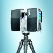
LAKE MARY, Fla., Oct. 5 /PRNewswire/ — FARO Technologies, Inc. (Nasdaq: FARO), the world’s leading provider of portable measurement and imaging solutions, introduces the new FARO Laser Scanner Focus3D.

Focus3D is a revolutionary, high-performance 3D laser scanner for detailed measurement and documentation with intuitive touch screen control that makes it as easy to operate as a digital camera. It is four times lighter and five times smaller than its predecessor and is the smallest and lightest laser scanner ever built.

Focus3D uses laser technology to produce incredibly detailed three-dimensional images of complex environments and geometries in only a few minutes. The resulting image is an assembly of millions of 3D measurement points in color which provides an exact digital reproduction of existing conditions.

The new FARO Laser Scanner Focus3D is suitable for documentation of large environments, quality control of components and reverse engineering. Thanks to its millimeter-accuracy and its 976,000 measurement points/second, the Focus3D offers the most efficient and precise method for measurement and three-dimensional documentation of building construction, excavation volumes, façade and structural deformations, crime scenes, accident sites, product geometry, factories, process plants and more.

The Focus3D is entirely self-contained, meaning no additional devices, cables or laptop are needed. With its dimensions of 9.5 x 8 x 4 in. and a weight of 11lbs, the Focus3D is so compact and mobile that users can always take it with them, wherever they go.

Focus3D deploys an integrated color camera with automatic and parallax free color overlay for photo-realistic 3D scans. Its integrated lithium-ion high-performance battery provides up to five hours of battery life and can be charged during operation. Furthermore, all scans are stored on a SD card enabling easy and secure data transfer to a computer.

The FARO Focus3D is compatible with many common software applications. The flexible interfaces of SCENE, the scan processing software included with the Focus3D, enable connection to AutoCAD as well as many other CAD applications such as Rhino, Microstation, Nemetschek and ArchiCAD.

FARO has changed the game with all the improvements and features of the new Focus3D, eclipsing anything offered in the marketplace and reducing the package size by 50%. Instead of pricing the technology accordingly, FARO has dropped the price by half that of any current laser scanning system.

“With the revolutionary Focus3D, FARO provides architects, civil engineers and plant designers with an efficient tool for rapid, seamless and precise documentation of the current status of buildings, plants and construction sites of every kind. The Focus3D offers advanced functionality through a simple user interface and expands the user base beyond the expert, moving phase shift laser scanning across the technology chasm,” stated Jay Freeland, FARO’s Chief Executive Officer.

About FARO

FARO develops and markets computer-aided coordinate measurement devices and software. Portable equipment from FARO permits high-precision 3D measurement and comparison of parts and compound structures within production and quality assurance processes. The devices are used for inspecting components and assemblies, production planning, inventory documentation, as well as for investigation and reconstruction of accident sites or crime scenes. They are also employed to generate digital scans of historic sites.

Worldwide, approximately 10,000 customers are operating more than 20,000 installations of FARO’s systems. The company’s global headquarters is located in Lake Mary, Florida, with its European head office in Stuttgart, Germany and its Asia/Pacifichead office in Singapore. FARO has branch locations in Canada, Mexico, United Kingdom, France, Spain, Italy, Poland, Netherlands, India, China, Singapore, Malaysia, Vietnam, Thailand, and Japan.

SOURCE FARO Technologies, Inc.

Back to top

RELATED LINKS
http://www.faro.com

FARO will launch a revolution in 3D at Intergeo 2010

FARO Technologies, a provider of portable 3D measurement and imaging solutions, says it will launch “revolutionary” 3D laser scanner technology at Intergeo 2010.

FARO will launch a revolution in 3D at Intergeo 2010“The time has come for a dramatic reinvention of 3D laser scanning by offering the most user friendly and easiest to handle scanner at a very affordable price,” explains Bernd Becker, director of product management and business development 3D Laser Scanner at FARO. “At Intergeo FARO will present a new revolutionary 3D laser scanner technology which makes 3D laser scanning available to a much larger audience.”

FARO will also demonstrate version 4.7 of SCENE which incorporates the new “one-click” Web-Share functionality. The SCENE Web-Share feature allows for easy and secure sharing of scan data via the internet. Scanned images can now be put on the internet by just a click of a button, thus enabling users to share scan information with their customers, suppliers and partners without the need of additional software.

FARO offers efficient modelling for the areas of architecture, civil engineering, tunnelling, heritage, product design, and process industry due to its software partner achievements, with one of the most important named as the new point cloud engine of AutoCad 2011.

Author
Michael Richards
This material is protected by Findlay Media copyright 2010.
See Terms and Conditions.
One-off usage is permitted but bulk copying is not.
For multiple copies contact the sales team.

Google Maps Street View 2.0 [LiDAR]

Brian Ussery is reporting that Google is back in Atlanta, GA making Street View images for Google Maps but, this time they brought in the big guns. Beu Blog reported on April 28, 2010, “The cars here today are equipped with GPS, high resolution panoramic cameras and multiple SICK sensors. These sensors collect LiDAR data that can be used for 3D imaging and visualizations like that seen in Radiohead’s recent “House of Cards” music video. Google Earth and SketchUp, Google’s 3D virtual building maker for Maps also use this type of data.

Last week Google announced the release of a plugin which allows users access to Google Earth imagery via Maps. As a result it’s now possible to view 3d images in Google Maps. The problem here is fairly obvious, Google Earth’s aerial imagery is taken from above and as a result not from the same perspective as users interacting with the data. Not to worry though, the StreetView team has been working on these kinds of problems for some time. When it comes to Navigation, Maps or StreetView, earthbound LiDAR enhanced imagery processed via Sketchup seems like a perfect complement to Google’s existing view from above. Combining high resolution imagery taken from the user’s perspective with advanced 3D image technology, presents some new possibilities to say the least. Factor in new releases like business ads in Maps, now being available in 3D on your mobile device and it’s pretty clear how Sketchup will be monetized.”

It is expected that Google’s incorporation of LiDAR into their mapping efforts will lead to some significant changes to our industry. If you have not previously seen the “House of Cards” video, be sure to check out the interactive music video code to see how Google made the point cloud data readily available for manipulation in a standard web browser. Point clouds are finally becoming more natively accepted in most CAD platforms and with Google getting involved in the industry, who knows where we will be in the near future.

National Center for Airborne Laser Mapping Comes to Houston [LiDAR]

April 12, 2010 – Houston – Increasing its cadre of laser mapping researchers, the University of Houston will expand its pioneering work in such areas as homeland security, disaster recovery, oil and gas exploration, wind farm site planning and environmental studies.

The NSF National Center for Airborne Laser Mapping (NCALM) and the groundbreaking researcher leading it recently moved operations to the University of Houston.  Based upon historical information, revenues generated by the center’s operation are anticipated to be $1 million per year and will be reinvested in the program.

NCALM is UH’s first and only NSF-supported center, established and sustained by funding from the National Science Foundation.  This differs from the way the university typically sets up centers, using university funds or grants from multiple sources for multiple projects.  These types of centers support NSF’s focus on interdisciplinary research, spanning several institutions and departments.

Ramesh Shrestha, Hugh Roy and Lillie Cranz Cullen Distinguished Professor of Civil and Environmental Engineering, brought NCALM to UH from the University of Florida.  He has been director of the center, focused on ground-based scanning laser technology and airborne laser swath mapping research, since it was established in 2003.  Shrestha brought much of his Florida team with him to Houston, where they now operate NCALM jointly with the University of California-Berkley.

“With the center, we have brought laser mapping’s uses to the forefront and expect to continue to have this impact in our new Houston home,” Shrestha said.  “We plan to establish curriculum catered to this specialty and eventually add a graduate degree in geosensing systems engineering.  This is in addition to carrying out research far surpassing what is capable in laser mapping to date.”

Shrestha’s work with laser mapping goes back to the 1990s, when this once niche research area was just making its debut.  Bill Carter, now a research professor at UH, worked with him early on and helped establish NCALM.

“Together, we saw its potential to far exceed what was possible with many traditional methods, such as airborne photogrammetric mapping that uses cameras to detail terrain,” Carter said.  “Laser mapping has the ability to work day or night, as well as generally map areas even though they were covered by forests and other vegetation where photogrammetric methods couldn’t.”

It wasn’t long before other scientists would see its same benefits, especially as the two developed techniques to remove and minimize some of the errors seen in the early years.  Their equipment became fine-tuned to collect even more data, now mapping as many as 167,000 points per second compared to the 3,000 they were able to achieve when they first started.

Their work has changed the way the state of Florida monitors erosion on its coastline, produced the highest resolution 3-D images in existence of the San Andreas Fault and taken them across the globe to map Mayan Ruins in Belize and volcanoes in Hawaii.  While the impact of their work is already far reaching, their plan for the coming years indicates they are not close to completion.  The value of this work is evident in evaluating the before and after of hurricanes and earthquakes in terms of improving building design and other mitigation efforts, as well as offering predictive tools for subsequent powerful events.

Aided by NSF, future NCALM efforts explore the possibility of using Light Detection and Ranging (LiDAR) to map everything from glacial movements to the migration of penguin colonies in Antarctica.  Using LiDAR, researchers take measurements of the ground’s surface from their Cessna 337 Skymaster airplane.

From roughly 2,000 feet, this remote technology measures properties of scattered light through the use of laser pulses.  Thousands of small cone-shaped pulses travel through a hole in the bottom of the plane to the ground below, and a unique detector picks up rays reflected from the ground.  Then, each point’s distance is determined by measuring the time delay between the transmission of a pulse and the detection of reflected signals.  The plane’s location and movement in the air are tracked by an inertial measurement unit fixed inside the laser system with a GPS receiver mounted to the plane and others on the ground.  Both are used, along with the laser data, to produce detailed 3-D topographical images of the terrain.

“In coming years, our group plans to develop a next-generation LiDAR system.  The unit would be less expensive than commercially available systems and allow for some of the most accurate, highest-resolution observations possible in laser mapping,” Shretha said.  “We want to develop a system like no one else has developed.  It would really change what could be done with this technology.  It would have new features, be faster, smaller and capture more during each flight than we can today.”

According to Shrestha, this system would use a much shorter pulse-length laser, increasing the number of points that could be mapped per second to 800,000.  This would add to data accuracy and reduce the amount of time needed in the air to collect the information.  Additionally, it would be able, for the first time, to penetrate shallow water depths.

###

NOTE TO JOURNALISTS: High-resolution photos of Ramesh Shretha and the Cessna 337 Skymaster airplane are available to media by contacting Lisa Merkl.

About the University of Houston
The University of Houston, Texas’ premier metropolitan research and teaching institution, is home to more than 40 research centers and institutes and sponsors more than 300 partnerships with corporate, civic and governmental entities.  UH, the most diverse research university in the country, stands at the forefront of education, research and service with more than 37,000 students.

About the Cullen College of Engineering
The Cullen College of Engineering at UH has played a vitally important role in educating engineers in Texas.  Taught by innovative faculty, eight of whom are in the National Academy of Engineering, the college offers degree programs in biomedical, chemical, civil, computer, electrical, environmental, industrial, mechanical and petroleum engineering, as well as specialty programs in materials, aerospace, and computer and systems engineering.

For more information about UH, visit the university’s Newsroom at http://www.uh.edu/news-events/.

To receive UH science news via e-mail, visit http://www.uh.edu/news-events/mailing-lists/sciencelistserv.php.

For additional news alerts about UH, follow us on Facebook and Twitter.