3D Visualization Comes Alive [Holograms]

Zebra Imaging Produces Printable 3D HologramsThree-dimensional space is a geometric model of the physical universe in which we live, work and are now entertained. Television manufacturers are quickly working to release the 3D-capable broadcasts that cable and satellite providers are already offering. For example, the 2010 Masters will be broadcast live in 3D on CBS, April 8-11. 3D movies used to be a rarity, but are now found weekly in theaters across the nation.

Physical 3D models have been used for decades to visualize City improvements in need of public approval and to help architects portray their ideas to the owner. Topographic contour maps have been used to visualize ground terrain in a two-dimensional environment for drainage studies, military strategy planning, city planning, etc. These models are often costly and take too long to construct.

Printed renderings are more easy and cost-effective to produce, but they lack the interactiveness of even the physical models.

The recent developments and adoption of Building Information Models (BIM) and intelligent 3D models have enabled architects and engineers to reach beyond just building a “pretty picture”. These “intelligent” models serve as a collaboration tool for designers working on different aspects of the project to visualize their designs and avoid any clashes during construction. Once the project is complete, this data can be used for detailed asset/facility life-cycle management.

The industry is now relying more on the virtual 3D models for design and construction and less on the typical 2D plans. However, we are still faced with the dilemma of having a working document that we can physically touch that represents the latest design. If only there was a way to have the best of both worlds – a 3D model on a 2D printed plan.

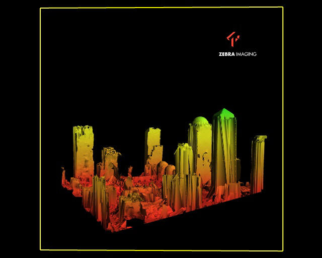
A while back I stumbled across Zebra Imaging through Twitter and after spending a day at their facility in Austin, Texas, I believe our industry is about to change. They produce full-color printed holographic images that can be used for numerous visualization applications including military planning project and concept demonstrations for investors.

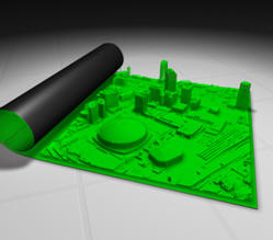
3D is now a standard output for most CAD systems, and is commonly used for viewing terrain data and built environments. ZEBRA Imaging offers a product that allows you to view this data from more than one angle, without having to redraw the images on a computer screen. ZEBRA Imaging provides fairly large – 600mm by 800mm – flat media holograms. They are portable and can be created using a number of data sources; most importantly, they don’t require special tools (e.g. glasses or scopes) for viewing.

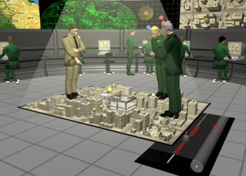
The holograms are used in a variety of ways, including military visualizations, project presentations and concept demonstrations for investors.

Monochrome view of New Orleans showing the Superdome.


From ZEBRA Imaging literature:

  • 3-D perspectives are visible horizontally and vertically; one can look over and under the image and from side to side without glasses or goggles
  • Wide angle of view – horizontal viewing is over 95 degrees, allowing many people to walk around and view an image simultaneously
  • Allows for unlimited size while maintaining the integrity of the image
  • Images are projected several feet in front of or behind the hologram and appear to be floating in air
  • Compact and portable – images are flat or flexible plastic panels that can be stored and shipped easily, taking up very little space
  • Any 3-D volumetric data set from any source may be used

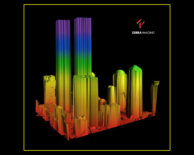
ZEBRA’s capabilities also include the ability to produce holograms that change depending upon the viewer’s angle. This is beneficial when attempting to depict varying levels of a building, terrain, etc. It is also helpful when trying to portray a particular image before and after an event. For example, Zebra created 3D visual of the Lower Manhattan skyline before and after 9-11. From one angle, a view of the Twin Towers before the disaster can be seen and from another, the rubble in the aftermath.

Before 9-11. (Click for larger image)
After 9-11. (Click for larger image)

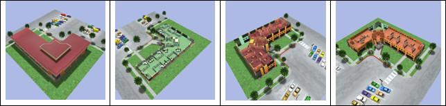
The four images below were used at the GEOINT Symposium to show the same corner at four different time periods. Each time the corner is viewed, it shows a different aspect of the structure.

(Click for larger image)
ZEBRA Imaging showed this example of generals looking at an urban area. The entire image is a color hologram – including the generals, the people in the background, etc.

Viewing a Zebra Imaging hologram is a viewing experience that is impossible to appreciate with the 2D limitations of a computer screen. The videos below give you an opportunity to understand how the real-world Zebra holograms appear through the lens of a 2D video camera.

Overview Video
A 2 minute overview showing a wide array of sample 3D Zebra holographic images
Windows Media – 5mbQuicktime – 24mb

Monochrome
A 15 second video that shows several monochrome samples (includes holograms not found in the Overview video)
Windows Media – 560kQuicktime – 3mb

Architecture

15 second video that shows several architectural holographic image samples
Windows Media – 640kQuicktime – 4mb

Automotive & Manufacturing

A 57 second video that shows automotive and other manufacturing 3D Zebra holographic images. Contains similar footage as the overview with a few more examples
Windows Media – 2.3mbQuicktime – 15mb

Industrial Design
30 second video containing several samples of industrial design holographic images
Windows Media – 1.2mbQuicktime – 5.4mb

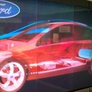
This image shows an interesting real-world application for the Ford Motor Company.

The first movie shows an interesting real-world application for the Ford Motor Company. This image shows the interior layout of a specific car.

A map is a model of reality that allows you to see, understand and analyze geography. ZEBRA Imaging’s offerings extend this model in a most interesting and utilitarian way.

Michael Klug, CTO of Zebra Imaging discusses the technology at Autodesk University 2009:

IBM Visualizes a “Smarter Planet” using 3D Laser Scanning Technology [LiDAR]

HOUSTON, TX March 18, 2010 Coign Asset Metrics & Technologies (CoignAMT), at the direction of Zoo Film Productions of Hollywood, CA, has helped produce IBM’s first globally released television commercial created entirely from Light Detection and Ranging (LiDAR) 3D point cloud data.

CoignAMT used the HDS6100 phase-based laser scanner from Leica Geosystems to create scenes of cars on a freeway, patients in a hospital, electricity grids and much more. The 30-second LiDAR-based commercial is a key part of IBM’s Smarter Planet initiative to portray that data is all around; and that by changing the way the world thinks, companies can maximize the use of data to lower their costs and reduce environmental impact.

Travis Reinke, business sector manager for CoignAMT, says, “Coincidentally, IBM’s perspective is a core part of CoignAMT’s business practice. We help our clients see the long-term value of the data they currently have by using the latest technology, such as 3D laser scanning, to quickly gather an immense amount of data to support their existing “intelligent” systems.”

The Zoo Film Productions crew spent a week in Houston, TX with CoignAMT personnel capturing laser scan data of transmission lines and over 16 blocks of downtown Houston streetscape and surounding buildings. CoignAMT then merged the point cloud data gathered in downtown with 6 square miles of low-altitude helicopter-based LiDAR provided by Aerotec LLC out of Birmingham, AL. Zoo Film Productions crews also created numerous scenes of hospital activities as well as automobiles with and without drivers that CoignAMT scanned individually for use in the commercial.

Reinke continues, “We were honored to be part of this innovative project given the direct correlation between the services CoignAMT provides and IBM’s Smarter Planet initiatives. Using the latest laser scanning technology to visually portray the importance of the data surrounding us was an unforeseen irony. I would never have imagined that we would be using this technology to scan people and cars, objects that are often considered ‘noise’ on a typical inventory project.”

View IBM “Data Anthem” at 848×480: http://www.glossyinc.com/zoo/ibmdataanthem.html
Full credits and a selection of stills: http://www.glossyinc.com/ibmdacred.html
Follow CoignAMT on Twitter: http://www.twitter.com/CoignAMT
Follow Travis Reinke on Twitter: http://www.twitter.com/HDLS

YouTube: http://www.youtube.com/watch?v=3cj6VtYpBI4

# # #

About Coign Asset Metrics & Technologies LLC:
Coign Asset Metrics & Technologies, LLC (CoignAMT) is a HUBZone qualified, SBA certified, small business that provides a full range of asset management life cycle services and specialized technologies, including high definition laser scanning (HDLS). Its mission is to strengthen public and private sector organizations by aligning their assets and operational practices with their strategic initiatives. CoignAMT is headquartered in the Pittsburgh, PA area, with regional offices located in Colorado Springs, CO, and Houston, TX. Clients include federal, state, and local governments, as well as private sector customers in the construction, energy, transportation, manufacturing, and security industries.

Boeing Launches Compact 3-D Imaging Camera

ALBUQUERQUE, N.M., March 8, 2010 — The Boeing Company [NYSE: BA] today announced it has begun offering a new, compact, energy-efficient camera that provides three-dimensional images for military and commercial applications.

Boeing Directed Energy Systems and wholly owned Boeing subsidiary Spectrolab have jointly developed the camera using their own research and development funding, and successfully tested it over the past two years by attaching it to mobile ground platforms and a Boeing AH-6 Little Bird helicopter. Equipped with advanced sensors that were developed by the Massachusetts Institute of Technology’s Lincoln Laboratory and transferred to Boeing under a teaming arrangement, the cube-shaped camera is one-third the size and uses one-tenth the power of most comparable 3-D imaging cameras.

“Our three-dimensional camera fits a lot of capability into a small package,” said Nasser Karam, vice president of Advanced Technology Products at Spectrolab. “Its compact design and modest power needs will allow it to be deployed on a wide range of platforms, including unmanned aerial and ground vehicles that don’t have much room or power to spare.”

The camera, which Boeing can customize for each customer, has many potential uses, including mapping terrain, tracking targets and seeing through foliage. To create a 3-D image, the camera fires a short pulse of laser light, then measures the pulse’s flight time to determine how far away each part of the camera’s field of view is.

“The camera combines cutting-edge sensor technology with Boeing’s advanced pointing and tracking solutions and real-time processing to provide our customers with highly integrated 3-D imaging payloads for ground, airborne or space-based applications,” said Joseph Paranto, Growth lead for Directed Energy Systems in Albuquerque.

Boeing is currently integrating the camera into compact 3-D imaging payloads on unmanned aerial vehicles and will be testing that capability this spring. The team will also add 3-D video capability to the camera soon to complement its existing still-image capability.

A unit of The Boeing Company, Boeing Defense, Space & Security is one of the world’s largest defense, space and security businesses specializing in innovative and capabilities-driven customer solutions, and the world’s largest and most versatile manufacturer of military aircraft. Headquartered in St. Louis, Boeing Defense, Space & Security is a $34 billion business with 68,000 employees worldwide.

Source: http://boeing.mediaroom.com/index.php?s=43&item=1107

Bentley Announces Integration of Pointools

Bentley Announces Point Cloud Integration using PointoolsPresented by: Executives from Spar Point research, Pointools, and Bentley

Summary:On October 14, 2009, Bentley announced that it had signed a “Continuous Technology Transfer Agreement” to incorporate Pointools’ Vortex Engine in the Bentley Technology Platform to enable reuse of 3D laser scanned data. This webinar will include three different perspectives on this agreement. To see the future of 3D data integration and platform interoperability you have to attend this webinar.

What you can learn:

  • An overview by Spar Point Research of the impact that laser scanning technology is having on the design, construction, and management of industrial plant, BIM, and civil/transportation infrastructure assets
  • The importance of integrating this technology into the daily workflows of infrastructure professionals and the value users will realize from this integration
  • A brief demonstration by Pointools of the Vortex engine functionality including an explanation on why the Pointools’ technology is so fast and so capable of handling billions of point clouds at one time
  • Watch this eSeminar by chapter:
    These videos open directly into your media player.

    Resources:

    Autodesk Announces Integrated LiDAR Solution

    The Autodesk® Subscription Advantage Pack for AutoCAD® Civil 3D® 2010 provides new functionality for importing and visualizing point clouds and designing roundabouts, and powerful enhancements that can help streamline existing workflows in AutoCAD® Civil 3D® 2010 software. This pack also includes Autodesk® ImageModeler™ 2009 software.

    This Subscription Advantage Pack is available exclusively for Autodesk® Subscription customers through download in the Autodesk Subscription Center.

    Features and Benefits

    Point Clouds—Import and visualize large sets of point cloud data, such as 3D laser scanning/LiDAR data sets with millions of points, in AutoCAD Civil 3D 2010 with the Point Clouds feature. The point cloud feature enables you to:

    Import LiDAR data in LAS format and all point file formats supported by AutoCAD Civil 3D 2010

    • Visualize large point clouds in 3D
    • Stylize point data based on LAS classifications, RGB, elevation, and intensity
    • Filter point data by style
    • Snap to points within the point cloud using standard AutoCAD® software tools

    Some common uses of LiDAR data in AutoCAD Civil 3D 2010 may include using the point cloud data for site surveys, developing an understanding of the site context, and digitizing as-built features (for example, building footprints and curbs) for design projects.

    Autodesk and partners released the following webcast overview. The meat of the relevant information starts at about the 35 minute marker. http://www.aec-projects.com/seminars/022510/

    SPAR 2010 Laser Scanning Conference Summary

    Due to inclement weather in Washington D.C., I was not able to make it back to The Woodlands in time for the first day of SPAR 2010, but I sure do have a lot to share with you after day 2. Below are some highlights from the well-attended event:

    Zebra Imaging – if you did not have a chance to see them in person, be sure to check out their website because they have developed a truly remarkable product. Zebra Imaging makes digitally-mastered, actively-animated, true-color, full-parallax holographic images. These holographic images are available in full color, or in monochrome (green). Zebra’s holographic images can be scaled to any size, large or small. By tiling together multiple tiles, it is possible to create large city maps, full sized cars, humans, and machinery. Check out a sample video of their technology here. Look for a full post about this technology after the conference.

    Trimble Indoor Mobile Mapping Solution (TIMMS) – Simply put, this technology is full-dome mobile scanning for interior applications. The technology uses the same IMU-type technology as aerial LiDAR and mobile mapping, but without the GPS. You simply push a cart around a facility to capture detailed, accurate point cloud data without the hassles of registration. Monthly rentals are available or you can purchase the technology.

    Z+F Camera Attachment for the Imager 5006iZ+F showed off a new digital camera attachment for the Imager 5006i/Leica HDS-6100. The camera mounts on top of the unit and integrates with the point cloud data through the use of their proprietary software. There are batch capabilities that allow application of the RGB values to be applied to multiple scans at once. These values are appended to the ZFS files without affecting the intensity values. It works flawlessly with the HDS6100, however, a hardware upgrade is needed in order to work with the HDS6000. The cameras can be purchased or leased from Z+F directly.

    Velodyne Lidar Inc. showed off their real-time 360-degree LiDAR sensor. Velodyne’s sensor was used on the Radiohead House of Cards music video directed by James Frost and Zoo Film Productions for which I recently had the privilege of working with on a new project. More on that once the project has been released… it is big, real big! In the meantime, check out the results from the Radiohead project. It is guaranteed to amaze you!

    Deke Smith gave a great presentation on the buildingSMART alliance and the National BIM Standard. Join at http://www.buildingsmartalliance.org. Download the Whole Building Design Guide at http://www.wbdg.org.

    I regret that I was not able to attend the first day, but it has been great to see colleagues I have not seen in a while and catch up on some new technology. Look for more info to be posted tomorrow. Follow us on Twitter for real-time updates from the conference.

    Leica Geosystems HDS4400 Long-Range 3D Laser Scanning Solution

    Leica Geosystems HDS has information a new long-range scanner posted on their product page. Check it out at http://hds.leica-geosystems.com/en/Leica-HDS4400_78316.htm

    The Leica HDS4400 mine scanning system offers all the benefits of laser scanning in a convenient, easy-to-learn and highly productive package. It is long range High-Definition Surveying (HDS) for the mining industry.

    The Leica HDS4400 mine scanning system offers all the benefits of laser scanning in a convenient, easy-to-learn and highly productive package. It’s long range High-Definition Surveying for the mining industry.

    The complete system includes the Leica HDS4400 scanner, a rugged field controller, software and support for mine scanning from the global leader in laser scanning solutions.

    The Leica HDS4400 offers users these advantages for long range, pulsed laser scanning:

    • Long range scanning with up to 700 m range
    • Integrated high-resolution digital camera for panoramic color images
    • Removal battery pack
    • 4400 points per second
    • Rugged tablet PC for easy scan control and data visualization

    Diversified Business Communications Acquires Spar Point Research

    Spar Point Research LLC has been acquired by Diversified Business Communications, a U.S.-based trade show, publishing and eMedia company headquartered in Portland, Maine.
    Tom Greaves, founder of Spar Point Research, will join the Diversified management team as managing director of the Spar Point Group. “We are excited about the future growth opportunities for Spar Point Group as part of Diversified,” Greaves said. “Diversified is a leading media and trade show organization with global reach and a proven record of strengthening the industries it serves. Diversified’s resources will allow our team to expand our geographic reach more quickly and better serve the needs of users and suppliers of 3D imaging technologies worldwide.“

    “Diversified is actively looking for opportunities to partner and acquire emerging industry franchises,” said Nancy Hasselback, president and CEO of Diversified Communications. “We see a tremendous opportunity for growth in 3D imaging technology.”

    “The Spar Point Group products are a great addition to our portfolio,” commented Mike Lodato, group vice president, who will be responsible for the corporate leadership of the Spar Point Group portfolio. “I look forward to working with Tom and the rest of the team to expand this franchise and leverage his expertise.”

    Spar Point Research LLC, a Massachusetts-based company, has organized SPAR conferences in the United States and Japan since 2003. SPAR 2010 will be held Feb. 8-10, 2010 in Houston, Texas, USA. SPAR 2010J will be held April 15-16, 2010 in Kawasaki, Japan. The company also publishes SparView, an electronic newsletter serving more than 12,000 readers from engineering, construction, manufacturing, law enforcement and security planning organizations worldwide.

    Diversified Business Communications provides information and market access through trade exhibitions, magazine publishing and eMedia products on four continents. Diversified serves a number of industries including seafood, food service, natural and organic products, commercial marine, integrative health care, oil and gas, and business management. Diversified operates divisions in Australia, Canada, Hong Kong, India and the UK. For more information, visit www.divbusiness.com.

    Investigators get 3-D crime scanner

    crime_scene_mgmt1_2405By Guillermo X. Garcia Express-News

    Bexar County’s criminal investigators soon will have cutting-edge help as they comb through crime scenes: a 3-D, computerized laser scanning system.

    County commissioners approved the $207,000 purchase Tuesday.

    “This is state-of-the-art equipment,” said Jose Treviño, the Sheriff’s Office homicide supervisor. “This will provide much more accurate data, and much quicker, to investigators at the scene.”

    The system, which will be operational by March, takes a 3-D electronic photograph that plots objects in a 360-degree scan.

    The unit “will all but eliminate human error” when it comes to measuring and plotting crime scene evidence, Treviño said.

    “Eliminating the human error means you’ll have much greater chance that evidence won’t be missed,” he added. “It also guarantees much more accuracy in documenting the evidence’s location.”

    Law enforcement officials say they plan to use the tool to probe major incidents, such as bank robberies, homicides and large-scale traffic accidents.

    The Leica Geosystems scanner the county is purchasing is similar to but newer than scanners used at Fort Hood to gather evidence in the shooting massacre that killed 13 people last month. A similar device also was used to reconstruct the Interstate 35 bridge collapse in Minneapolis in August 2007.

    Under a regional contract, surrounding counties and municipalities also will have access to the equipment, said Sheriff Amadeo Ortiz.

    In other business, the commissioners were briefed on a project that will allow county residents to electronically request and track work orders for repairs to roads, sidewalks, bridges, signs and drainage structures.

    Once operational, residents can access the Public Works Citizens Request Portal to create an electronic work request. The system also will provide status reports on all pending projects on a given street or in a neighborhood, said County Engineer Renee Green.

    She said the public will be able to access the program starting Jan. 4.

    graphic

    3D mapping drone fires lasers from a mile away (video)

    by Vladislav Savov @ Engadget posted Nov 18th 2009 at 6:40AM

    The MIT Technology Review has unearthed a new laser-based 3D mapping robot that can produce results similar to those obtained from $100,000 systems at about a fifth of the cost. Funded by the US Army, researchers at the Stevens Institute of Technology have now demonstrated the Remotely Operated and Autonomous Mapping System (ROAMS, for short), which employs a mirror-based LIDAR system that bounces a laser off a rapidly rotating mirror and gleans environmental information from how long it takes for each pulse to bounce back. An array of video cameras and IR proximity sensors add to this recon bot‘s sentience, though you’ll still need to be within a mile’s range to operate it. So not quite yet ready for solo missions to Mars, but plenty useful for gathering data on our own planet. You’ll find video and imagery of the results this machine kicks out after the break.