Laser Scanning Guide to Good Practice [Archaeology]

The Archaeology Data Service is currently undertaking a collaborative two-year project with Digital Antiquity to broaden and update their series of Guides to Good Practice. The project will encompass important revisions of the existing six ADS Guides as well as the development of entirely new documents covering areas such as marine scanning, laser scanning, GPS, digital audio and digital video. Previous authors have been asked to revise existing content and new authors, from both Europe and the US, will contribute to the development of the guides into new themes and areas.

The project is in collaboration with the Digital Antiquity initiative, a US-based project with the aim of enhancing the preservation of and access to digital records of archaeological investigations. A major aim of the Guides is to provide the basis for archaeological project workflows that will create digital datasets that can be archived and shared effectively by Digital Antiquity’s tDAR repository in the US and by the Archaeology Data Service in the UK. The development of the Guides involves close collaboration with teams in the US at both the University of Arkansas and Arizona State University.

Other ADS projects are also planned to feed into the revision and development of the Guides. ADS involvement in the European VENUS project will result in one of the first published guides focussing on marine scanning and photogrammetry. In addition, the incorporation of findings from the ADS Big Data project, together with the revision of the existing guide on aerial photography and remote sensing data, will see a significant contribution to the guides from English Heritage funded projects.

The new Guides are under development and only selected sections are publicly available. The new Guides to Good Practice are scheduled to be released in January 2011.

Excerpt from Laser Scanning A Guide to Good Practice

By Angie Payne
Edited by Kieron Niven

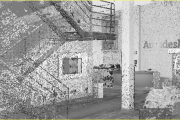
This guide serves as a guide to good practice for the collection and archival of point cloud datasets and the additional derived products produced by terrestrial laser scanners in cultural heritage applications. It is recommended to read this guide in conjunction with Section 7 of the Metric Survey Specifications for Cultural Heritage (Bryan et al 2009) titled ‘Standard Specification for the Collection and Archiving of Terrestrial Laser Scan Data’ published by English Heritage. The Metric Survey Specifications for Cultural Heritage provides an excellent foundation for discussion of key project elements particularly project planning, data collection, and preliminary processing of terrestrial scan data. A lot of these points will be reiterated throughout this document. This guide builds upon the specifications provided by the Metric Survey Specifications for Cultural Heritage by broadening the scope to include such topics as accurate RGB/color acquisition and by also suggesting standards for archiving the derived products of point cloud datasets. Other key resources that were influential in the creation of this guide are 3D Laser Scanning for Heritage (English Heritage 2007) and Theory and Practice on Terrestrial Laser Scanning (3D Risk Mapping 2008).

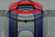
This guide is not a “How To” document that describes methods for collecting and processing scan data but rather a guide to inform individuals of key considerations and metadata elements to document in scanning projects that will allow them to easily archive their heritage datasets. The graphic below shows the key steps of data acquisition and processing, metadata documentation, and data archival for laser scan datasets.These key areas form the basis for discussion for Sections 2 and 3 of this document; Section 1 provides introductory material and Section 4 provides a case study and sample metadata. It is our hope that the metadata elements discussed here will easily integrate into most heritage scanning projects and will promote the ease in archiving and the long term preservation of these valuable datasets.

Archaeology laser scanning guide to good practice workflow

The full draft is available for review at http://guides.archaeologydataservice.ac.uk/g2gp/LaserScan_Toc.

Microsoft Unknowingly Revolutionizes the 3D Imaging Industry [Kinect]

Being the bleeding edge technology geeks that we are here at SCANable, we have been closely following Microsoft’s adoption of Israeli developer PrimeSense’s controller-less motion capture technology which interprets 3D scene information from a continuously-projected infrared structured light. Now released as the Kinect for Xbox 360, or simply Kinect (originally known by the code name Project Natal), defined as a “controller-free gaming and entertainment experience” by Microsoft for the Xbox 360 video game platform, and may later be officially supported by PCs. Based around a webcam-style add-on peripheral for the Xbox 360 console, it enables users to control and interact with the Xbox 360 without the need to touch a game controller, through a natural user interface using gestures, spoken commands, or presented objects and images. The project is aimed at broadening the Xbox 360’s audience beyond its typical gamer base. Kinect competes with the Wii Remote with Wii MotionPlus and PlayStation Move motion control systems for the Wii and PlayStation 3 home consoles, respectively.

Weeks before the Kinect was officially released, the hacking community was hard at work digging through this revolutionary hardware in order to test the true limits of its capabilities. There was even a bounty of $3,000 offered by development company “Adafruit” to obtain an open-source driver. A mere two days after the bounty was announced, that goal had already been reached — this according to an email Adafruit’s Phillip Torrone sent Gizmodo. Drivers have been available for Mac and Linux for a couple of weeks, but there are now working drivers for Windows for which we have successfully tested here at SCANable. Our early assessment has indicated that this inexpensive device is actually capable of  much more than just a game controller. To our amazement, we discovered that it continuously captures 3d point cloud data of everything in your living room/game room. By tapping into the Kinect with a PC (Mac, Linux or Windows), we were able to gain full access to this multi-purpose 4-dimensional data with the ability to freely move around the feed in real-time. Using the OpenKinect drivers and basic viewing software, we were even able to set cut-planes which gave us the ability to isolate the moving object in the scene and view this data as colored depth ranges or true RGB color generated by the units embedded camera.

Drivers:
Kinect drivers for Windows can be found here.
Drivers for Mac and Linux can be found here.

The possibilities of this technology are tremendous. We see a near future where we can navigate through a point cloud dataset or virtual 3D model using simple hand gestures (see Evoluce’s example below). Imagine being able to digitally record “true” 3D video and having the ability to easily remove data at certain depths instead of by color eliminating typical green screen procedures. Even better, what if you strapped one of these bad boys onto a robotic vacuum and used it to remotely capture 3D data of interior spaces. Think we are crazy? Keep reading…

How does it work?
Wired has a great article about!

Canesta-Howitworks1

Examples:

We have compiled several of the best videos of the Kinect in-use. Check them out and be sure to post comments below. We all are masters of manipulating point cloud data, let’s pull together our resources and expertise and come up with some great applications for this affordable technology!

Evoluce, one of the leading manufacturers of high-quality multi-touch and gesture computing displays, demonstrates the future of how we interact with our computers.

MIT early experiments with a Microsoft Kinect depth camera on a mobile robot base. Say hello to KinectBot. Is this the indoor mobile mapping solution we have been waiting for?

Kinect-style device used to map the interior of a building:

For the launch of Xbox Kinect in Germany, seeper created an interactive projection mapping. Set at the highly visible Stachus in central Munich, this project attracted hoards of participants. Immersed in the experience, users took part in epic particle ball games, sending fluids shooting three stories high. Together with guests, including Sylvie van der Vaart, we explored the limits of controller free gaming!

Kinect used for real-time lightsaber:

What are your thoughts about this revolutionary device? Be sure to leave your comments and feedback below. Also be sure to check back here over the coming weeks for new updates!

Orlando Police Department Awards Leica Geosystems Employee for Assistance with Police Investigation of Workplace Shooting

(Orlando, FL November 8, 2010) At a ceremony honoring those citizens who provided assistance to the victims and the investigative efforts of the Orlando Police Department in the aftermath of the Gateway Plaza workplace shooting, Orlando Chief of Police Val Deming presented Leica Geosystems employee Frank J. Hahnel, III with OPD’s Good Citizen Award for his on-scene assistance in documenting the homicide scene using Leica’s ScanStation C10 3D laser scanning technology.  Hahnel is an Orlando resident and is Leica Geosystems’ Accident Investigation Account Manager for North America.

It was on November 6th, 2009 that Jason Rodriquez opened fire on former colleagues at the engineering firm he had been let go from killing one and injuring five.  Hours later Orlando Police tracked Rodriquez to his mother’s home where he peacefully surrendered.  The crime scene left behind was a large and daunting one encompassing most of the eighth floor of an office building where Rodriguez had stalked the hallways shooting his victims.  Shortly after securing the crime scene the OPD reached out to Hahnel who had only recently provided a demonstration to the agency on the capabilities of the ScanStation C10.

The ScanStation C10 is an eye-safe and easy-to-use portable 3D laser scanner that can both panoramically photograph a scene and then capture over 3.5 million survey quality measurements in less than two minutes.  The technology is used by law enforcement agencies all over the world for crime scene investigation, vulnerability and threat assessments, post-blast investigation, police action inquiries, accident investigations and more.  Hahnel responded to the call-out and systematically scanned the crime scene from 45 different perspectives to document the scene in 3D.

“The ScanStation cut the time required to do our work in half by eliminating the need to manually measure the scene” said Karen Livengood an OPD Crime Scene Investigator.  “Additionally, the data from the ScanStation lets you virtually walk through the crime scene in 3D, which makes for a clearer presentation to the jury in court” she added.

Following the award presentation by Chief Deming and Orlando Mayor Buddy Dyer, Hahnel expressed his sympathy for the victims and his appreciation for being recognized.  “Helping with the investigation was a life-changing event for me as I had never seen the results of such a violent crime.  I am grateful to have been able to help the police in the community in which I live”.

Leica Geosystems – when it has to be right

With close to 200 years of pioneering solutions to measure the world, Leica Geosystems products and services are trusted by professionals worldwide to help them capture, analyze, and present spatial information. Leica Geosystems is best known for its broad array of products that capture accurately, model quickly, analyze easily, and visualize and present spatial information.
Those who use Leica Geosystems products every day trust them for their dependability, the value they deliver, and the superior customer support. Based in Heerbrugg, Switzerland, Leica Geosystems is a global company with tens of thousands of customers supported by more than 3,500 employees in 28 countries and hundreds of partners located in more than 120 countries around the world. Leica Geosystems is part of the Hexagon Group, Sweden.

To view this release on the web please click here: http://www.leica-geosystems.us/forensic/press_19.html

For further information regarding the use of HDS for Accident Investigation contact:

Frank J. Hahnel, III
Accident Investigation Account Manager
Leica Geosystems Inc.
407.421.0873 phone
frank.hahnel@lgshds.com
www.lgshds.com
www.leica-geosystems.us/forensic

Leica Geosystems launches a dedicated forensics program for law enforcement

Leica Geosystems launches a dedicated forensics program for law enforcement at this year’s worldwide 3D laser scanning conference.

As part of its eighth annual Worldwide User Conference devoted to 3D laser scanning in San  Ramon, California, USA (near San Francisco), Leica Geosystems successfully launched a program devoted specifically to the law enforcement and public safety community.  The event drew law enforcement agencies and forensic professionals from around the United States and the world over a four day period October 24-27, 2010.

Of special interest was the seven-hour “live fire” shooting reconstruction workshop titled “3D Laser Scanning of Shooting Scenes and Trajectories” taught by Mike Haag of the Albuquerque Police Department’s Major Crime Scene Team.   Mr. Haag has used the Leica ScanStation on dozens of cases for shooting reconstruction and he is a Distinguished Member of the Association of Firearms and Tool Mark Examiners.   Over 30 law enforcement professionals attended this class on a very rainy and wet Sunday at the Contra Costa County Sheriff’s Department who provided their facility.  The weather didn’t inhibit the operation of the Leica ScanStation C10 or the enthusiasm of the class which learned the fundamentals and best practices of shooting incident reconstruction and trajectory measurement using 3D laser scanning.

The Leica Geosystems ScanStation C10 is an easy-to-use, compact and portable 3D laser scanner that measure 3.5 million points at a scene in less than two minutes in any lighting conditions.  The system does not require any special eye protection when used, is robust and captures the leveled survey-quality data required for accurate crime scene reconstruction and analysis.

In recent years  many public safety agencies across a broad spectrum of law enforcement—County Sheriff’s departments, metropolitan police agencies and state investigative agencies—have acquired Leica ScanStations and now deploy them regularly for a wide range of tasks, including crime scene investigation,  officer involved shootings and threat assessments of buildings and other infrastructure.  Increasingly, criminal prosecutors are relying on compelling images and animations created with the system to present evidence to juries and to effectively counter the so-called “CSI effect.”

Dr. John DeHaan, of California-based Fire-Ex Forensics, Inc. an internationally recognized expert in his field and the author of Kirk’s Fire Investigation was the first speaker in the general session with a presentation titled “Documenting Fire and Explosion Scenes with Leica ScanStation Technology.” After guiding the audience through multiple cases including a home destroyed by a gas leak and an ambulance (VBIED) rigged with an explosive device as a test exercise Dr. DeHaan itemized 11 significant benefits and advantages of Leica’s ScanStation technology over other methods.

“Based on the recent, extremely rapid uptake of HDS for forensics and homeland security applications,” explained Tony Grissim, Leica Geosystems Public Safety and Forensic Accounts Manager, “the launch of a dedicated law enforcement track at this year’s conference demonstrates how seriously Leica Geosystems is committed to serving the needs of the law enforcement community.”  Grissim added that portions of the program were recorded and will be available on Leica’s forensic web site at www.leica-geosystems.com/us/forensic

Leica Geosystems—when it has to be right.

With close to 200 years of pioneering solutions to measure the world, Leica Geosystems is trusted by professionals worldwide to help them capture, analyze and present spatial information. The company is best known for its broad array of products that accurately capture, model quickly, analyze easily, visualize and present spatial information. Based in Heerbrugg, Switzerland, Leica Geosystems is a global company with tens of thousands of customers supported by more than 3,500 employees in 28 countries and hundreds of partners located in more than 120 countries. Leica Geosystems is part of the Hexagon Group, Sweden.

To view this release on the web please click here

http://www.leica-geosystems.us/forensic/press_18.html

For further information regarding the use of HDS for Accident Investigation contact:

Frank J. Hahnel, III
Accident Investigation Account Manager
Leica Geosystems Inc.
407.421.0873 phone
frank.hahnel@lgshds.com
www.lgshds.com
www.leica-geosystems.us/forensic

Leica Geosystems 2010 HDS Worldwide User Conference – Day 1

The conference kicked off this morning with some great presentations including a live preview of Cyclone 7.2 and its new pcE high speed visualization engine.

Some of the more interesting presentations today also included:

– Explosion Dynamics Research/Forensic Investigations using HDS, presented bu Dr. John DeHaan, FireEx Forensics
– Ken Smerz, Kovach Construction/Precision 3D Scanning, gave an excellent presentation on the benefits of laser scanning for the precise fabrication of complex wall systems.
– Alan Barrow, ABA Surveying, showed how he is using 3 HDS6000’s, a LandINS IMU and Javad GNSS mounted on the back of a van for near survey-grade mobile scanning.
– Luncheon keynote updating us on the status of the Mt. Rushmore CyArk project was given by Liz Lee and Doug Pritchard. They showed some remarkable images of the project.
– Zebra Imaging is displaying their latest high-resolution, full-color holographic prints in their booth. They have some great examples of full-color point clouds and detailed Building Information Models.

The day ended with a great social evening of food and bocce at Campo di Bocce Ristorante & Bar.

We are looking forward to more great presentations over the next couple of days. Be sure to follow us at www.twitter.com/scanable for live updates throughout the event.

FARO Introduces the Focus3D – the Smallest and Lightest 3D Laser Scanner Ever Built

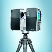
LAKE MARY, Fla., Oct. 5 /PRNewswire/ — FARO Technologies, Inc. (Nasdaq: FARO), the world’s leading provider of portable measurement and imaging solutions, introduces the new FARO Laser Scanner Focus3D.

Focus3D is a revolutionary, high-performance 3D laser scanner for detailed measurement and documentation with intuitive touch screen control that makes it as easy to operate as a digital camera. It is four times lighter and five times smaller than its predecessor and is the smallest and lightest laser scanner ever built.

Focus3D uses laser technology to produce incredibly detailed three-dimensional images of complex environments and geometries in only a few minutes. The resulting image is an assembly of millions of 3D measurement points in color which provides an exact digital reproduction of existing conditions.

The new FARO Laser Scanner Focus3D is suitable for documentation of large environments, quality control of components and reverse engineering. Thanks to its millimeter-accuracy and its 976,000 measurement points/second, the Focus3D offers the most efficient and precise method for measurement and three-dimensional documentation of building construction, excavation volumes, façade and structural deformations, crime scenes, accident sites, product geometry, factories, process plants and more.

The Focus3D is entirely self-contained, meaning no additional devices, cables or laptop are needed. With its dimensions of 9.5 x 8 x 4 in. and a weight of 11lbs, the Focus3D is so compact and mobile that users can always take it with them, wherever they go.

Focus3D deploys an integrated color camera with automatic and parallax free color overlay for photo-realistic 3D scans. Its integrated lithium-ion high-performance battery provides up to five hours of battery life and can be charged during operation. Furthermore, all scans are stored on a SD card enabling easy and secure data transfer to a computer.

The FARO Focus3D is compatible with many common software applications. The flexible interfaces of SCENE, the scan processing software included with the Focus3D, enable connection to AutoCAD as well as many other CAD applications such as Rhino, Microstation, Nemetschek and ArchiCAD.

FARO has changed the game with all the improvements and features of the new Focus3D, eclipsing anything offered in the marketplace and reducing the package size by 50%. Instead of pricing the technology accordingly, FARO has dropped the price by half that of any current laser scanning system.

“With the revolutionary Focus3D, FARO provides architects, civil engineers and plant designers with an efficient tool for rapid, seamless and precise documentation of the current status of buildings, plants and construction sites of every kind. The Focus3D offers advanced functionality through a simple user interface and expands the user base beyond the expert, moving phase shift laser scanning across the technology chasm,” stated Jay Freeland, FARO’s Chief Executive Officer.

About FARO

FARO develops and markets computer-aided coordinate measurement devices and software. Portable equipment from FARO permits high-precision 3D measurement and comparison of parts and compound structures within production and quality assurance processes. The devices are used for inspecting components and assemblies, production planning, inventory documentation, as well as for investigation and reconstruction of accident sites or crime scenes. They are also employed to generate digital scans of historic sites.

Worldwide, approximately 10,000 customers are operating more than 20,000 installations of FARO’s systems. The company’s global headquarters is located in Lake Mary, Florida, with its European head office in Stuttgart, Germany and its Asia/Pacifichead office in Singapore. FARO has branch locations in Canada, Mexico, United Kingdom, France, Spain, Italy, Poland, Netherlands, India, China, Singapore, Malaysia, Vietnam, Thailand, and Japan.

SOURCE FARO Technologies, Inc.

Back to top

RELATED LINKS
http://www.faro.com

FARO will launch a revolution in 3D at Intergeo 2010

FARO Technologies, a provider of portable 3D measurement and imaging solutions, says it will launch “revolutionary” 3D laser scanner technology at Intergeo 2010.

FARO will launch a revolution in 3D at Intergeo 2010“The time has come for a dramatic reinvention of 3D laser scanning by offering the most user friendly and easiest to handle scanner at a very affordable price,” explains Bernd Becker, director of product management and business development 3D Laser Scanner at FARO. “At Intergeo FARO will present a new revolutionary 3D laser scanner technology which makes 3D laser scanning available to a much larger audience.”

FARO will also demonstrate version 4.7 of SCENE which incorporates the new “one-click” Web-Share functionality. The SCENE Web-Share feature allows for easy and secure sharing of scan data via the internet. Scanned images can now be put on the internet by just a click of a button, thus enabling users to share scan information with their customers, suppliers and partners without the need of additional software.

FARO offers efficient modelling for the areas of architecture, civil engineering, tunnelling, heritage, product design, and process industry due to its software partner achievements, with one of the most important named as the new point cloud engine of AutoCad 2011.

Author
Michael Richards
This material is protected by Findlay Media copyright 2010.
See Terms and Conditions.
One-off usage is permitted but bulk copying is not.
For multiple copies contact the sales team.

Point Cloud Tools for 3D Studio [Project Helix]

Bring your visualizations into context with Project Helix, a powerful technology prototype enabling display and rendering of 3D laser scanning/LiDAR data sets with Autodesk® 3ds Max® and Autodesk® 3ds Max® Design software. With the 3ds Max Point Cloud Tools you can more quickly import as-built site references to help evaluate and visualize your designs in context of their surrounding elements. Point cloud data sets are often created by 3D scanners and represent set of measured vertices in a three-dimensional coordinate system. Using an automatic process, these devices measure in a large number of points on the surface of an object and output a point cloud as a data file. Download Now

The Point Cloud Tool for 3ds Max and 3ds Max Design allows you to:

  • Import .PTS format point cloud data into 3ds Max or 3ds Max Design scenes (release 2010 & 2011)
  • Display the point cloud data in the 3ds Max viewport with a variety of rendering options and levels of detail
  • Render point clouds using the mental ray® renderer*
  • Slice point clouds into pieces using geometric display volumes
  • Export multiple clouds or parts of clouds to new .PTS files

* mental ray is a registered trademark of mental images GmbH licensed for use by Autodesk, Inc.

The Project Helix Technology Preview will be made available only for a limited time, so download Project Helix before June 20, 2011 and place your designs in context today!

If you would like to try the Point Cloud Tool for 3ds Max with a sample data set:


FEATURED VIDEOS

If you do not have access to YouTube videos, you can download the video from as 3ds Max Point Cloud Tools.mp4.

Point Cloud Shape Extraction for AutoCAD Plug-in

The Point Cloud Shape Extraction for AutoCAD Plug-in is an intelligent point cloud shape extraction solution which allows you to import, load, and extract shape and geometry information from point cloud data in AutoCAD. Once installed, the tools for point cloud shape extraction are located in Point Cloud tab on the ribbon user interface. Download Now

Sample Data

To experiment with Shape Extraction for AutoCAD, you can download some sample data. The zip file contains 5 samples: Cup.pcg, Football.pcg, Mandalay.pcg, Pipe.pcg, and Room.pcg.

Availability

To ensure the best experience for those participating, this technology preview is currently limited to: Australia, Canada, Ireland, New Zealand, Singapore, United Kingdom, and United States. We hope to expand to other geographies in the future.

The Shape Extraction for AutoCAD technology preview is licensed for a limited term and for a particular territory as referenced in the End User License Agreement. The technology preview will operate until February 1, 2011.

For those without YouTube access, the videos are available for download via this blog article.

Google Maps Street View 2.0 [LiDAR]

Brian Ussery is reporting that Google is back in Atlanta, GA making Street View images for Google Maps but, this time they brought in the big guns. Beu Blog reported on April 28, 2010, “The cars here today are equipped with GPS, high resolution panoramic cameras and multiple SICK sensors. These sensors collect LiDAR data that can be used for 3D imaging and visualizations like that seen in Radiohead’s recent “House of Cards” music video. Google Earth and SketchUp, Google’s 3D virtual building maker for Maps also use this type of data.

Last week Google announced the release of a plugin which allows users access to Google Earth imagery via Maps. As a result it’s now possible to view 3d images in Google Maps. The problem here is fairly obvious, Google Earth’s aerial imagery is taken from above and as a result not from the same perspective as users interacting with the data. Not to worry though, the StreetView team has been working on these kinds of problems for some time. When it comes to Navigation, Maps or StreetView, earthbound LiDAR enhanced imagery processed via Sketchup seems like a perfect complement to Google’s existing view from above. Combining high resolution imagery taken from the user’s perspective with advanced 3D image technology, presents some new possibilities to say the least. Factor in new releases like business ads in Maps, now being available in 3D on your mobile device and it’s pretty clear how Sketchup will be monetized.”

It is expected that Google’s incorporation of LiDAR into their mapping efforts will lead to some significant changes to our industry. If you have not previously seen the “House of Cards” video, be sure to check out the interactive music video code to see how Google made the point cloud data readily available for manipulation in a standard web browser. Point clouds are finally becoming more natively accepted in most CAD platforms and with Google getting involved in the industry, who knows where we will be in the near future.