The Point Cloud Shape Extraction for AutoCAD Plug-in is an intelligent point cloud shape extraction solution which allows you to import, load, and extract shape and geometry information from point cloud data in AutoCAD. Once installed, the tools for point cloud shape extraction are located in Point Cloud tab on the ribbon user interface. Download Now
Sample Data
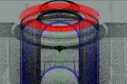
To experiment with Shape Extraction for AutoCAD, you can download some sample data. The zip file contains 5 samples: Cup.pcg, Football.pcg, Mandalay.pcg, Pipe.pcg, and Room.pcg.
Availability
To ensure the best experience for those participating, this technology preview is currently limited to: Australia, Canada, Ireland, New Zealand, Singapore, United Kingdom, and United States. We hope to expand to other geographies in the future.
The Shape Extraction for AutoCAD technology preview is licensed for a limited term and for a particular territory as referenced in the End User License Agreement. The technology preview will operate until February 1, 2011.
Leica Geosystems Announces the Release of Leica CloudWorx™ 1.0 for SmartPlant 3D
(Heerbrugg, 21 July 2009) Leica Geosystems announces the immediate availability of Leica CloudWorx™ 1.0 for SmartPlant 3D. This powerful and easy-to-learn point cloud solution is designed for Intergraph SmartPlant 3D users who want to take full advantage of accurate, laser scan as-built data directly in SmartPlant 3D.
Leica CloudWorx™ 1.0 for SmartPlant 3D is the latest addition to the Leica CloudWorx suite of products that enable professionals to use rich, as-built point cloud data directly in their native desktop design and visualization platform. SmartPlant 3D is Intergraph’s next generation plant design platform.
Key features and capabilities of Leica CloudWorx™ 1.0 for SmartPlant 3D – Measure – using SmartPlant 3D’s own measuring tools – Automated clash checking – using SmartPlant 3D’s built-in clash management and reporting tools – Pipe centerline routing tools and exact tie-point location tools – for finding face of flange at pipe center; supports creation of intelligent as-built models directly in SmartPlant 3D, using catalog components and objects – Leica Geosystems’ unique Key Plan features – for visual fast navigation within point cloud project data – Leica Geosystems’ unique TruSpace viewer – delivers improved comprehension of point cloud data and ease of driving exact viewpoints in the CAD system – Easy point cloud management – by Scan, “Limit Box”, “Cutplane slices and sections”, and “Hide Region” – Supports a variety of laser scanners – including native data formats from Leica Geosystems scanners, the industry’s most popular scanners – CloudWorx toolbars – access CloudWorx operations easily, conveniently, and fast;
visualize a new design concept directly in context with reality
High Accuracy Plus High Performance
Leica CloudWorx for SmartPlant 3D is based on Leica Geosystems’ long proven database-centric Cyclone™ point cloud foundation, which allows users to simultaneously benefit from state-of-the-art spatial accuracy and high performance point cloud management.
Powerful Point Cloud Management & Measurement in SmartPlant 3D
Leica CloudWorx for SmartPlant 3D provides several ways to quickly, efficiently, and effectively manage vast amounts of point cloud data. User named and defined “Cutplane Slices and Half-Space Sections” and/or “Limit Boxes” provide a quick and easy way to navigate point cloud data. These selections can be recalled as needed on demand. The Key Plan and TruSpace viewpoint management tools provide unsurpassed ease-of-use and improved visual comprehension. Measurements are taken using familiar SmartPlant 3D measuring tools.
Automated Point Cloud Clash Detection and Reporting Using SmartPlant 3D
Clash detecting against point clouds with Leica CloudWorx is performed using SmartPlant 3D’s own automated clashing and reporting tools. Users can automatically detect clashes between modeled objects and point clouds, based on a user’s own defined tolerance settings. All interfering points within a user-defined region are visually highlighted and itemized.
Supports Multiple Scanner Formats
Leica CloudWorx for SmartPlant 3D lets Intergraph’s users take advantage of spatial scan data from any laser scanner via industry-standard ASCII-based data formats. In addition, Leica CloudWorx for SmartPlant 3D directly accepts, without any data format conversion, compact native data formats from the industry’s most popular scanners. These include all models of Leica Geosystems High-Definition Surveying™ (HDS™) time-of-flight and phase-based laser scanners, and selected scanners from other vendors. This capability to accept native formats from the industry’s most popular scanners provides users with even higher overall system efficiencies and simpler workflows.
Pricing & Availability
Leica CloudWorx 1.0 for SmartPlant 3D is immediately available from Leica Geosystems. Pricing information is available through appropriate Leica Geosystems representatives and dealers worldwide.
Leica Geosystems – when it has to be right
With close to 200 years of pioneering solutions to measure the world, Leica Geosystems products and services are trusted by professionals worldwide to help them capture, analyze, and present spatial information. Leica Geosystems is best known for its broad array of products that capture accurately, model quickly, analyze easily, and visualize and present spatial information.
Those who use Leica Geosystems products every day trust them for their dependability, the value they deliver, and the superior customer support. Based in Heerbrugg, Switzerland, Leica Geosystems is a global company with tens of thousands of customers supported by more than 3’500 employees in 28 countries and hundreds of partners located in more than 120 countries around the world. Leica Geosystems is part of the Hexagon Group, Sweden.
For further information please contact:
Leica Geosystems AG
Bill Wallace
Sr. Product Manager, Software
https://scanable.com/wp-content/uploads/2025/01/SCANable_logo_emblemSimple-180x180.png00Travis Reinkehttps://scanable.com/wp-content/uploads/2025/01/SCANable_logo_emblemSimple-180x180.pngTravis Reinke2009-07-22 08:42:502009-07-22 08:42:50Leica Geosystems Announces the Release of Leica CloudWorx™ 1.0 for SmartPlant 3D