
Mobile Scanners Enter the Rental Market
The Only Portable Mobile Mapping & GIS Data Collection Solution is now available for daily, weekly and monthly rental.
![]() Mobile Surveying Systems or Mobile Mapping Systems, as they are becoming known, are not new. Several laser manufacturers have introduced and sold Mobile Mapping Systems over the last few years. The difference is that these systems (with one exception) are adaptations of tripod mounted (static) laser scanners. They are all large, very heavy, complicated and very, very expensive.
Mobile Surveying Systems or Mobile Mapping Systems, as they are becoming known, are not new. Several laser manufacturers have introduced and sold Mobile Mapping Systems over the last few years. The difference is that these systems (with one exception) are adaptations of tripod mounted (static) laser scanners. They are all large, very heavy, complicated and very, very expensive.
Measurement Devices Ltd. announces the world-wide availability of Dynascan equipment hire/rental giving even the smallest survey organizations the ability to add mobile mapping to its service offering, enabling them to undertake previously undreamed of ‘detailed 3D, large scale mapping projects’, formerly the domain of large companies or government organizations. Productivity of Laser Surveying Systems will no longer be measured in terms of “Points per Second” but in terms of “Square Miles per Hour” and available for the same cost-effective daily hire rate as static terrestrial 3D laser scanning systems (i.e. Leica Geosystems ScanStation C10, HDS6200, HDS7000).
Furthermore, MDL has assembled a global team of LiDAR industry experts to provide field and office support services and custom-tailored training on “real-world” workflows and procedures. Travis Reinke, Chief Operating Officer of Measurement Devices US, LLC stated, “By providing easy access to the latest technology and expertise, we are able to change the decision-making process. Project managers and the like now have the ability to integrate new technologies into their workflows without the huge risk of taking on large capital expenditures. We’re disrupting the market by introducing mobile mapping to the masses.”
MDL’s new business model of providing ‘complete measurement solutions’ gives greater support to customers with irregular or infrequent resource needs or project specific requirements. Reinke went on to add, “Our highly-skilled team of professionals are available to ensure that first-time users are successful on their first project. We accomplish this by offering a discounted bundled rate for an experienced technician and the mobile system when needed.”
MDL’s mission is:
- To assist and enable more end-users in the real-world application of various rapid 3D data capture technology by providing easy access to a comprehensive range of equipment rental, consultancy and education.
- To help end-users close the information gap between the Hardware/Software Vendors and the real world.
- To empower and educate our client base in order to enhance industry growth and spawn further advancements.
- To support customers with irregular or infrequent resource needs or project specific requirements.
With decades of combined experience gained from a real world application of laser measurement systems, MDL’s team of industry professionals has obtained a highly qualified and proven skill set focused on Quarry and Mining Surveying, Dynamic Land Surveying, High Definition Surveying, and Hydrographic Surveying.
Eliminate the Investment Risk
- Rent equipment until you’re ready to buy – expense on per project basis.
- Take advantage of knowledgeable experts with real world experience to support your project team.
- Ramp up or down as needed to keep your capital expenditures minimal.
- Rely upon our experience to provide you with practical user information and get more than just a demo.
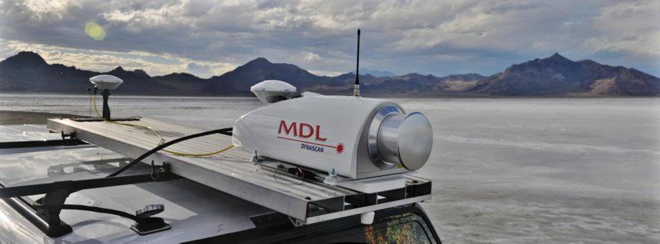
The Dynascan ‘Plug and Play’ LIDAR system is a fully integrated high speed laser scanner, high accuracy GPS positioning system and Inertial Measurement Unit. The system is light weight, highly portable and may be used on land vehicles or marine vessels to acquire 3D survey quality data of topography, urban developments, industrial plants, including overhead utility cables, bridges, dams, harbors, beaches, rivers and canal banks, and much more.
By fully integrating all the sensors in one package, MDL has eliminated the need for field calibrations as all sensor offset measurements are fixed during the factory calibration process and pre-configured in the data acquisition software. The LIDAR system is shipped ready for operation and can be mobilized in a matter of minutes.
Dynascan system comes complete with data acquisition and post processing software suite which is compatible with all known brand multi-beam echo sounders, swathe sonar systems, positioning systems and Inertial Measurement Units. Data from all available sensors is synchronized, “Time Tagged” and Recorded. Post processed and raw data may be exported to most 3D data base and CAD software packages. Dynascan is highly affordable and represents an unrivalled ‘Price-Performance’ advantage, opening up the benefits of 3D LIDAR to numerous applications and market opportunities.

Leave a Reply
Want to join the discussion?Feel free to contribute!