Boeing Launches Compact 3-D Imaging Camera

ALBUQUERQUE, N.M., March 8, 2010 — The Boeing Company [NYSE: BA] today announced it has begun offering a new, compact, energy-efficient camera that provides three-dimensional images for military and commercial applications.

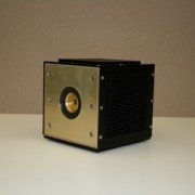
Boeing Directed Energy Systems and wholly owned Boeing subsidiary Spectrolab have jointly developed the camera using their own research and development funding, and successfully tested it over the past two years by attaching it to mobile ground platforms and a Boeing AH-6 Little Bird helicopter. Equipped with advanced sensors that were developed by the Massachusetts Institute of Technology’s Lincoln Laboratory and transferred to Boeing under a teaming arrangement, the cube-shaped camera is one-third the size and uses one-tenth the power of most comparable 3-D imaging cameras.

“Our three-dimensional camera fits a lot of capability into a small package,” said Nasser Karam, vice president of Advanced Technology Products at Spectrolab. “Its compact design and modest power needs will allow it to be deployed on a wide range of platforms, including unmanned aerial and ground vehicles that don’t have much room or power to spare.”

The camera, which Boeing can customize for each customer, has many potential uses, including mapping terrain, tracking targets and seeing through foliage. To create a 3-D image, the camera fires a short pulse of laser light, then measures the pulse’s flight time to determine how far away each part of the camera’s field of view is.

“The camera combines cutting-edge sensor technology with Boeing’s advanced pointing and tracking solutions and real-time processing to provide our customers with highly integrated 3-D imaging payloads for ground, airborne or space-based applications,” said Joseph Paranto, Growth lead for Directed Energy Systems in Albuquerque.

Boeing is currently integrating the camera into compact 3-D imaging payloads on unmanned aerial vehicles and will be testing that capability this spring. The team will also add 3-D video capability to the camera soon to complement its existing still-image capability.

A unit of The Boeing Company, Boeing Defense, Space & Security is one of the world’s largest defense, space and security businesses specializing in innovative and capabilities-driven customer solutions, and the world’s largest and most versatile manufacturer of military aircraft. Headquartered in St. Louis, Boeing Defense, Space & Security is a $34 billion business with 68,000 employees worldwide.

Source: http://boeing.mediaroom.com/index.php?s=43&item=1107

Leica Geosystems HDS4400 Long-Range 3D Laser Scanning Solution

Leica Geosystems HDS has information a new long-range scanner posted on their product page. Check it out at http://hds.leica-geosystems.com/en/Leica-HDS4400_78316.htm

The Leica HDS4400 mine scanning system offers all the benefits of laser scanning in a convenient, easy-to-learn and highly productive package. It is long range High-Definition Surveying (HDS) for the mining industry.

The Leica HDS4400 mine scanning system offers all the benefits of laser scanning in a convenient, easy-to-learn and highly productive package. It’s long range High-Definition Surveying for the mining industry.

The complete system includes the Leica HDS4400 scanner, a rugged field controller, software and support for mine scanning from the global leader in laser scanning solutions.

The Leica HDS4400 offers users these advantages for long range, pulsed laser scanning:

  • Long range scanning with up to 700 m range
  • Integrated high-resolution digital camera for panoramic color images
  • Removal battery pack
  • 4400 points per second
  • Rugged tablet PC for easy scan control and data visualization

3D mapping drone fires lasers from a mile away (video)

by Vladislav Savov @ Engadget posted Nov 18th 2009 at 6:40AM

The MIT Technology Review has unearthed a new laser-based 3D mapping robot that can produce results similar to those obtained from $100,000 systems at about a fifth of the cost. Funded by the US Army, researchers at the Stevens Institute of Technology have now demonstrated the Remotely Operated and Autonomous Mapping System (ROAMS, for short), which employs a mirror-based LIDAR system that bounces a laser off a rapidly rotating mirror and gleans environmental information from how long it takes for each pulse to bounce back. An array of video cameras and IR proximity sensors add to this recon bot‘s sentience, though you’ll still need to be within a mile’s range to operate it. So not quite yet ready for solo missions to Mars, but plenty useful for gathering data on our own planet. You’ll find video and imagery of the results this machine kicks out after the break.

Trimble Develops Next Generation 3D Laser Scanner for Industrial Plant Applications

3D Laser Scanner Combines Phase and Time of Flight Technologies for Fast and Accurate Data Capture

SUNNYVALE, Calif., Oct. 29, 2009 — Trimble (NASDAQ: TRMB) introduced today the Trimble® CX 3D laser scanner with Trimble’s proprietary WAVEPULSE™ technology. WAVEPULSE combines the high short-range accuracy of phase-shift technology with the low-noise sensitivity and high-distance characteristics of time-of-flight technology. The result is high-precision measurements over the full operating range that provides the clean 3D data needed for industrial plant scanning applications—allowing the user to realize increased productivity and reduced operating costs. And by requiring fewer setups and enabling faster processing time in an industrial plant environment, the Trimble CX solution can contribute to improved worker safety.

Built for Efficiency in the Plant

The Trimble CX solution is built for efficient data capture in the plant. With reliable scanning at 50,000 points per second and an 80 meter range with a 360 degree x 300 degree field of view, the solution provides widespread and efficient data capture from a single setup. A rugged design, IP54 rating and protective housing for the rotating laser allow the scanner to deliver continuous and reliable results even in difficult industrial environments. An integrated camera collects additional image information that can improve the visualization, post-processing and communication of the captured data.

The Trimble CX is supported by Trimble Access™ software for Spatial Imaging, which runs on the Trimble Tablet rugged PC. Powerful and built for industrial conditions, the Trimble Tablet combines a large, daylight readable display, IP67 environmental rating and long battery life that can easily withstand the demands of plant environments. With intuitive and streamlined Trimble Access Software, capturing data with the Trimble CX requires a very short learning curve. Data can be seamlessly transferred to Trimble’s 3D scanning office software packages: Trimble RealWorks™ and Trimble LASERGen™ software.

Certified Application for Tank Measurements

The Trimble CX solution also includes 3D Extractor software specifically developed for storage tank calibration. The software can significantly reduce the time taken to calibrate storage tanks while also providing a richer data set that can be used for monitoring tank deformations. The Trimble CX is certified by the Physikalisch-Technischen Bundesanstalt (the German National Metrology Institute, PTB).

An Integral Solution for Plant Lifecycle Management

Managing a plant’s lifecycle requires a clear understanding of the location and condition of the plant’s assets. The Trimble CX 3D laser scanning solution can be used for a variety of industrial plant positioning applications:

  • Capturing existing condition data for accurate project planning for basic and detailed design;
  • Ensuring dimensions of fabricated parts prior to transportation and installation;
  • Verifying as-built construction for quality assurance and additional detailed design;
  • Visualizing real world conditions for training and simulation;
  • Monitoring plant assets and potential movement or deformation during use;
  • Planning retrofit construction projects based upon accurate data and;
  • Calibrating storage tanks by determining filling tables and sump volumes.

The Trimble CX is expected to be available in the fourth quarter of 2009.

About Trimble’s Power, Process and Plant Division

Trimble’s Power, Process and Plant Division provides a comprehensive range of positioning solutions to transform the plant lifecycle work process—from design and construction to ongoing operation and maintenance.Trimble’s 3D laser scanning hardware and software provides: increased productivity by delivering fast, accurate data with minimal impact to plant operations or project timelines; reduced rework by providing highly accurate existing condition data; and can contribute to improved worker safety through the fast acquisition of data when in the industrial plant environment. Trimble’s solutions are used in the oil & gas, power generation and manufacturing industries.

For more information about Trimble’s Power, Process and Plant solutions visit: www.trimble.com/plant.

About Trimble

Trimble applies technology to make field and mobile workers in businesses and government significantly more productive. Solutions are focused on applications requiring position or location—including surveying, construction, agriculture, fleet and asset management, public safety and mapping. In addition to utilizing positioning technologies, such as GPS, lasers and optics, Trimble solutions may include software content specific to the needs of the user. Wireless technologies are utilized to deliver the solution to the user and to ensure a tight coupling of the field and the back office. Founded in 1978, Trimble is headquartered in Sunnyvale, Calif.

Investor Relations Contact: Willa McManmonof Trimble: 408-481-7838
Media Contact: LeaAnn McNabb of Trimble: 408-481-7808

Hexagon Metrology Unveils Leica T-Scan TS50A Laser Scanner

NORTH KINGSTOWN, RI, Jun 18, 2009 – Hexagon Metrology, Inc. announces the new Leica T-Scan TS50-A hand-held laser scanner, which interfaces with the Leica Absolute Tracker. The new Leica T-Scan delivers improvements that result in a doubling of the data acquisition rate, a fifty percent improvement in scanned point density, and scanner accuracy improved by a third. Together, these changes deliver 6DoF laser scanning performance that makes contact-free measuring faster, more accurate, and more efficient.

The core of the product improvements lie with the unit’s laser and optics system, which result not only in greater scanner accuracy, but also improved data quality, with a reduction in system noise, and an improved ability to scan all types of surfaces, particularly ones that are shiny or dark, under all lighting conditions. The scanner is capable of self-adjustment to lighting conditions, independent of the operator. Combined with the Leica Absolute Tracker system, the new T-Scan has improved system specifications of up to 25%.

“The TS50A is the third generation T-Scan unit, and offers great improvements with absolutely no compromises,” said David Armstrong, product manager, portable products for Hexagon Metrology, Inc. “The increased sampling speed will be of particular interest for the T-Scan’s core applications of digitizing and inspecting very large objects, such as aircraft or portions of aircraft, and the large blades for wind turbines. With usable scanning volumes of 59 feet (medium range system) or 98 feet (long range system) from the base unit, it really is an unbeatable solution for large volume 3D scanning.”

Ergonomic handling, robust design for shop floor and even outdoor environments, and improved accuracy specifications make the T-Scan TS50 scanner an ideal solution for automotive, aerospace, wind power, shipbuilding, defense and heavy equipment applications. The T-Scan TS50a is available for immediate shipment with Leica Absolute Trackers.

About Leica Geosystems Metrology Products

Whether building the fastest car, the biggest plane, or the most precise tooling, you need exact measurements to improve quality and productivity. So when it has to be right, professionals trust Leica Geosystems Metrology to help collect, analyze, and present 3-dimensional (3D) data for industrial measurement. Leica Geosystems Metrology is best known for its broad array of control and industrial measurement products including laser trackers, Local Positioning Technology (LPT) based systems, hand-held scanners, 3D software and high-precision total stations. Those who use Leica Geosystems Metrology products every day trust them for their dependability, the value they deliver, and the world-class service and support that is second to none. Precision, reliability and service from Leica Geosystems Metrology.

About Hexagon Metrology

Hexagon Metrology serves the high precision measurement and inspection needs of worldwide manufacturers with its extensive line of metrology hardware, software, accessories, and customer services. The company’s name-brand portfolio of quality assurance products include Brown & Sharpe, CogniTens, Leica Geosystems, ROMER, Sheffield, PC-DMIS, DEA, Leitz, m&h, and TESA. Hexagon Metrology has an unrivaled installed base of more than 1.5 million handheld, stationary and portable measurement devices, and over 30,000 seats of PC-DMIS metrology software.

For more information, visit www.hexagonmetrology.us

3D Laser Mapping/Riegl Brings World’s Fastest, Lightest Laser Scanner to the UK

Nottingham, UK – 3D Laser Mapping has announced the UK launch of the world’s fastest and lightest mobile laser scanner. Designed to instantly 3D map buildings, infrastructure and highways to 5mm accuracy within half a kilometre, the Riegl VZ-400 represents a new generation of laser scanner technology. Weighing just 10kg and carried in a handy rugged briefcase, the added portability, accuracy and speed is set to revolutionise 3D field mapping.

Part of the Riegl V-Line range the VZ-400 utilises unique echo digitisation to achieve superior performance and accuracies of measurement, even under adverse weather conditions. The evaluation of multiple targets combined with a reliable, robust and lightweight construction makes the VZ-400 ideally suited to civil engineering, city modelling and architectural projects.

The Riegl VZ-400 is part of the newly released V-Line Range. The first to offer Online Waveform Analysis and Echo Digitisation the Riegl V-Line Laser Scanners enable measurement of multiple targets, with improved accuracy for distance measurements, combined with very high measurement and scanning rates and output of a quality indicator for each measurement.

“The results from these field trials prove the performance and capability of the VZ-400 laser scanner,” commented Dr Graham Hunter, Managing Director of 3D Laser Mapping. “Even under the harshest operating conditions the VZ-400 captures very high accuracy measurements, at speed and with a level of quality no seen before.”

Riegl has over thirty years experience in the research, development and production of laser rangefinders, distancemeters and scanners. Primarily a technology company Riegl specialise in producing technically innovative solutions for specific applications working in partnership with organisations such as 3D Laser Mapping to produce powerful turnkey solutions for multiple fields of application.

A Riegl Premier Distributor, 3D Laser Mapping is a global developer of laser scanning solutions for sectors such as mapping, mining and manufacturing. 3D Laser Mapping specialises in integrating laser scanning hardware with their own software and peripherals to create solutions at the cutting edge of technology.