When players and caddies wonder just how far away the hole is from where they’re standing and what club they should use, one of them typically pulls out a yardage book.
The bright orange booklet prepared for this year’s U.S. Open contains some high-tech improvements in its exact measurements of every spot along the 7,400-yard course. It’s a must-read for anyone who challenges the beastly Black Course at Bethpage State Park.
“Whether you’re making a putt, a drive, or using an iron, it’s all about distance,” explained George Lucas, the former caddie for Arnold Palmer. Lucas compiled the first yardage book in 1976. “When you have a yardage book, you can make the best determination of distance.”
This year’s yardage book for the Open used laser scanning to create images of the putting greens and some GPS technology to make its measurements more accurate than ever, said Bryan Wilson, an official with Houston-based Stracka Design Co., which recently teamed up with Lucas. The company has prepared yardage books for some 600 courses worldwide, and offers them each year for every course played on the PGA Tour.
The book on Bethpage Black, for example, warns players to look out on hole No. 15 – one of the course’s most challenging – for a birdhouse to the left followed later by a small tree, with the exact yardage to the hole from each point along the way. And with laser scanning, players and their caddies can study the contours, dips and bumps on each putting green.
The degree of difficulty at Bethpage makes the book particularly important, Lucas said. “It may be the hardest golf course ever made,” he explained. “It doesn’t need the weather to be tough. There are no tricks. It’s just one tough course.”
https://scanable.com/wp-content/uploads/2025/01/SCANable_logo_emblemSimple-180x180.png00Travis Reinkehttps://scanable.com/wp-content/uploads/2025/01/SCANable_logo_emblemSimple-180x180.pngTravis Reinke2009-06-14 22:06:562009-06-14 22:06:56Laser, GPS technology goes into yardage book
Nottingham, UK – 3D Laser Mapping has announced the UK launch of the world’s fastest and lightest mobile laser scanner. Designed to instantly 3D map buildings, infrastructure and highways to 5mm accuracy within half a kilometre, the Riegl VZ-400 represents a new generation of laser scanner technology. Weighing just 10kg and carried in a handy rugged briefcase, the added portability, accuracy and speed is set to revolutionise 3D field mapping.
Part of the Riegl V-Line range the VZ-400 utilises unique echo digitisation to achieve superior performance and accuracies of measurement, even under adverse weather conditions. The evaluation of multiple targets combined with a reliable, robust and lightweight construction makes the VZ-400 ideally suited to civil engineering, city modelling and architectural projects.
The Riegl VZ-400 is part of the newly released V-Line Range. The first to offer Online Waveform Analysis and Echo Digitisation the Riegl V-Line Laser Scanners enable measurement of multiple targets, with improved accuracy for distance measurements, combined with very high measurement and scanning rates and output of a quality indicator for each measurement.
“The results from these field trials prove the performance and capability of the VZ-400 laser scanner,” commented Dr Graham Hunter, Managing Director of 3D Laser Mapping. “Even under the harshest operating conditions the VZ-400 captures very high accuracy measurements, at speed and with a level of quality no seen before.”
Riegl has over thirty years experience in the research, development and production of laser rangefinders, distancemeters and scanners. Primarily a technology company Riegl specialise in producing technically innovative solutions for specific applications working in partnership with organisations such as 3D Laser Mapping to produce powerful turnkey solutions for multiple fields of application.
A Riegl Premier Distributor, 3D Laser Mapping is a global developer of laser scanning solutions for sectors such as mapping, mining and manufacturing. 3D Laser Mapping specialises in integrating laser scanning hardware with their own software and peripherals to create solutions at the cutting edge of technology.
https://scanable.com/wp-content/uploads/2025/01/SCANable_logo_emblemSimple-180x180.png00Travis Reinkehttps://scanable.com/wp-content/uploads/2025/01/SCANable_logo_emblemSimple-180x180.pngTravis Reinke2009-06-13 19:39:412009-06-13 19:39:413D Laser Mapping/Riegl Brings World’s Fastest, Lightest Laser Scanner to the UK
This is old news, but it is worth posting here for users thinking about purchasing point cloud software in the near future.
Ottawa, Canada, Tuesday, September 23, 2008 — Autodesk, Inc. has signed an agreement with Ambercore Software to license its point cloud technology and incorporate
it into future releases of Autodesk software. Point clouds are extremely large data files usually created through the use of laser scanning, high definition surveying, or LIDAR (Light Detection and Ranging). They provide a more accurate representation of existing conditions whether of a terrain surface or urban center, a roadway or bridge, or the interior/exterior of a building.
The Ambercore Software point cloud technology will enable customers to read, store, index, and quickly retrieve the extremely large data sets associated with laser scanning and LIDAR. As a result they will be able to visualize and analyze data in 3D and better build high-precision 3D models. Examples of customer benefits include:
• Local government, utility and telecommunications customers will be able to maximize the return on their investment in large-scale LIDAR mapping and infrastructure projects.
• AEC customers will experience the power of Building Information Modeling (BIM) earlier in the project lifecycle. By providing the capability to incorporate highly accurate LIDAR data into the design process, we will provide a foundation for creating more accurate designs faster. This will be particularly beneficial to our civil engineering customers involved in road and highway design.
“The point cloud technology from Ambercore Software will allow Autodesk customers to easily incorporate extremely large and highly accurate LIDAR data into the design and infrastructure management process,” said Lisa Campbell, vice president, Autodesk Geospatial. “The incorporation of this technology into Autodesk’s portfolio of Geospatial and Building Information Modeling software means that our customers will be able to start with a digital model earlier in the design process or expand the precision and detail of existing infrastructure databases. As a result they will be able to create more accurate design and mapping information and use that information to visualize, simulate, and analyze projects before they are built.”
“Ambercore’s point cloud software has been engineered to efficiently manipulate extremely large spatial data,” said Martin Sendyk, President and CEO of Ambercore Software. “With the increasing proliferation of 3D sensing equipment and resultant point cloud data, the ability to extract intelligence from massive 3D data sets is more important than ever. We are very excited to be solving this challenge with an innovative company like Autodesk.”
About BIM
BIM is an integrated process built on coordinated, reliable information about a project from design through construction and into operations. By adopting BIM, architects, engineers, contractors and owners can easily create coordinated digital design information and documentation; use that information to more accurately visualize, simulate and analyze performance, appearance and cost; and reliably deliver the project faster, more economically and with reduced environmental impact
About Autodesk
Autodesk, Inc. is the world leader in 2D and 3D design software for the manufacturing, building and construction, and media and entertainment markets. Since its introduction of AutoCAD software in 1982, Autodesk has developed the broadest portfolio of state-of-the-art digital prototyping solutions to help customers experience their ideas before they are real. Fortune 1000 companies rely on Autodesk for the tools to visualize, simulate and analyze real-world performance early in the design process to save time and money, enhance quality and foster innovation. For additional information about Autodesk, visit http://www.autodesk.com.
About Ambercore
Ambercore provides enterprise-scale software and service solutions for Energy, Mining and natural resource sectors. With its powerful spatial modeling and simulation software, Ambercore helps clients make important business decisions by collecting, integrating and analyzing 2D and 3D spatial information. Ambercore’s Terrapoint Division has provided LiDAR and other digital mapping services for a diverse clientele in over forty countries for the past twenty years. Terrapoint’s primary focus is to find solutions that fit client needs, and to continue a reputation for meeting and exceeding client demands in the delivery of digital elevation and image data. Service and product offerings include complete airborne LiDAR, and digital imaging for engineering, survey and mapping applications. Ambercore’s TITAN® Division develops leading edge mobile LiDAR systems for ground based high accuracy applications. Best of breed solutions comprised of software, hardware and services have been deployed internationally with tier-one clients. Ambercore is headquartered in Ottawa, Canada with offices in Houston, Calgary, South Africa and Europe. For more information please see www.ambercore.com
Ambercore, Terrapoint, and TITAN are registered trademarks or trademarks of Ambercore Software Inc., and/or its subsidiaries and/or affiliates, in the USA and/or other countries. All other brand names, product names, or trademarks belong to their respective holders. Ambercore reserves the right to alter product offerings and specifications at any time without notice, and is not responsible for typographical or graphical errors that may appear in this document.
Autodesk and AutoCAD are registered trademarks or trademarks of Autodesk, Inc., and/or its subsidiaries and/or affiliates, in the USA and/or other countries.
https://scanable.com/wp-content/uploads/2025/01/SCANable_logo_emblemSimple-180x180.png00Travis Reinkehttps://scanable.com/wp-content/uploads/2025/01/SCANable_logo_emblemSimple-180x180.pngTravis Reinke2009-06-12 11:13:262009-06-12 11:13:26Autodesk to Incorporate Point Cloud Capability in Future Releases of AutoCAD
ILoveSketch, a 3D curve sketching system that captures some of the affordances of pen and paper for professional designers, allowing them to iterate directly on concept 3D curve models. The system coherently integrates existing techniques of sketch-based interaction with a number of novel and enhanced features. Novel contributions of the system include automatic view rotation to improve curve sketchability, an axis widget for sketch surface selection, and implicitly inferred changes between sketching techniques. We also improve on a number of existing ideas such as a virtual sketchbook, simplified 2D and 3D view navigation, multi-stroke NURBS curve creation, and a cohesive gesture vocabulary.
https://scanable.com/wp-content/uploads/2025/01/SCANable_logo_emblemSimple-180x180.png00Travis Reinkehttps://scanable.com/wp-content/uploads/2025/01/SCANable_logo_emblemSimple-180x180.pngTravis Reinke2009-06-04 13:34:502009-06-04 13:34:50Great New Interface for Complex 3D Modeling
Note: Hexagon Metrology is owned by Hexagon AB Group which also ownes Leica Geosystems. It will be interesting to see if any of this functionality will end up in Cyclone.
North Kingstown, RI – June 2, 2009 – Wilcox Associates, a Hexagon Metrology company, announces the immediate availability of PC-DMIS Reshaper software as a standlone application. PC-DMIS Reshaper is a comprehensive 3D point-cloud processing program that can be used to collect or import large quantities of 3-dimensional point data for manipulation and processing for downstream processes such as CAD modeling, Computer Aided Manufacturing (CAM) or rapid prototyping.
PC-DMIS Reshaper operates as a fully functional application in an online or offline mode. Data collection can be accomplished “live” via a direct connection to a digitizing device, such as a ROMER portable measuring arm with a laser scanner, or offline via file import from more than a dozen 3D data file formats, including STEP, IGES, ASCII, DXF, DMIS, ISO and RAW.
Point clouds, which can be imported with no file size or point quantity limitations, can be cleaned, merged, and edited from the streamlined user interface, and then rapidly converted into a polygon mesh model. The conversion from cloud to mesh is extremely rapid, utilizing proprietary alogorithms for polygon organization that results in highly accurate, yet lightweight file size models. Further manipulation of mesh models, including hole filling, deformation, and smoothing is rapidly accomplished with point-and click simplicity. Final export of meshes is possible to a dozen file fomats.
“PC-DMIS Reshaper is an excellent package for the user who wants to do a relatively discrete set of tasks, namely collection and cleanup of point clouds, and quickly getting them into a format that can be taken to the next stage in the development process. It has a short learning curve and is very intuitive to use,” said Ken Woodbine, President of Wilcox Associates, Inc. “At the moment, PC-DMIS Reshaper is a standalone module, but in time, we will be incorporating elements of the technology into the core PC-DMIS product suite.
A basic set of point cloud to CAD comparison dimensional inspection is also possible with PC-DMIS Reshaper. A point cloud can be aligned to an IGES or STEP CAD model, and deviations from nominal shown in a colored graphical “weathermap” format. This function is ideal for users who wish to compare a physical object, such as a mold cavity, to its virtual CAD counterpart. Deviations indicate areas of variation to the original model.
PC-DMIS Reshaper software benefits functional areas such as product development, rapid prototyping and reverse engineering, plus industries that create or use molds and dies, or produce parts with complex surfaces. Even heritage preservation can benefit from using PC-DMIS Reshaper software to collect 3D models of priceless artifacts for archival or copy purposes.
Wilcox Associates (PC-DMIS)
Wilcox Associates is a Hexagon Metrology company. Founded in 1990, Wilcox Associates, Inc. is the developer of PC-DMIS, the world’s leading CMM software, and Enterprise Metrology Solutions (EMS), a tightly integrated suite of software products focused on the collection, evaluation, management and presentation of manufacturing data. These products allow manufacturers to quickly capture dimensional data, analyze it and act on it to reduce scrap, improve throughput and reduce costs.Wilcox Associates, Inc. employs over 100 talented software engineers located worldwide working in a collaborative environment. They are dedicated to bringing our customers the best metrology software technology possible. More information can be found at www.PC-DMIS.com
Hexagon Metrology
Hexagon Metrology is part of the Hexagon AB Group and includes leading metrology brands such as Brown & Sharpe, CE Johansson, CimCore, CogniTens, DEA, Leica Geosystems (Metrology Division), Leitz, m&h, PC-DMIS, QUINDOS, ROMER, Sheffield and TESA. Hexagon Metrology brands represent an unrivaled global installed base of millions of CMMs, portable measuring systems and handheld instruments, and tens of thousands of metrology software licenses. Hexagon Metrology empowers its customers to fully control manufacturing processes that rely on dimensional precision, ensuring that products manufactured precisely conform to the original product design. The company offering of machines, systems and software is complemented by a wide range of product support, aftermarket and value-added services. More information can be found at www.HexagonMetrology.us
Officials at Mount Rushmore National Memorial have added new tools in the constant effort to preserve the national icon.
While crews traditionally use silicone sealant, fracture-mapping techniques and other technology to preserve the faces, they have added laser scanning and digital mapping to tools use to keep the 68 year old in good condition.
Duane Bubac, director of cultural resources and facilities at Mount Rushmore National Memorial, said the mapping project will give the National Park Service detailed information about the features of Mount Rushmore. And the data could later be used to create virtual, up-close tours of Mount Rushmore.
In the past, maintenance was mostly a once-a-year event. Each fall, rope-access crews descended from the top of the memorial to inspect the granite and caulk the surface cracks. The fall maintenance work still takes place every September, Bubac said, but it’s now part of a much larger, year-around effort to monitor and preserve Mount Rushmore National Memorial.
“The process involves a lot more than sealing cracks now,” Bubac said.
Under the National Park Service long-range preservation plan, crews are fracture-mapping and crack-mapping the granite surface. They are also removing vegetation, cleaning and sealing cracks, removing hazard rocks and testing the next generation of sealant materials.
Mount Rushmore’s biggest threat is water. It seeps into cracks, freezes and expands. That freeze-thaw cycle could eventually degrade the surface of the granite. Dirt and vegetation could also be a threat. If dirt can accumulate in a small hollow, it gives opportunist weeds, bushes or trees the foothold they need to take root.
https://scanable.com/wp-content/uploads/2025/01/SCANable_logo_emblemSimple-180x180.png00Travis Reinkehttps://scanable.com/wp-content/uploads/2025/01/SCANable_logo_emblemSimple-180x180.pngTravis Reinke2009-06-02 10:46:322009-06-02 10:46:32Mount Rushmore to add laser scans, digital mapping in preservation efforts
In October 2006 I was sitting in my office at Microsoft trawling through a backlog of email and voice messages. It had been a busy couple of months leading up to the Technology Preview of Photosynth at San Francisco’s Web 2.0. We’d brought the house down with our on stage demonstration of Photosynth’s ability to take a large number of digital images and automatically assemble them into a high resolution, 3D environment that anyone could explore at home from within their web browser.
Around the same time, Chris Kemp (Currently CIO at NASA Ames) had just joined the Agency and was leading their business development efforts to seek out new and emerging technologies coming out of the private sector that could help NASA’s mission. He had seen the Photosynth demo and was eager to learn more about what he’d seen. He was full of ideas and saw the potential for Photosynth to bring the public closer to the space program than they had ever been before. They could follow in the tracks of the Mars Rovers, see every nut and bolt of a shuttle on the launch pad and experience first hand life onboard the International Space Station (ISS). At Microsoft Live Labs we were bringing some of the top computer scientists in the world together with talented engineers to explore new ground on the web. We couldn’t have asked for a more kindred spirit than the men and women of NASA who, through their own genius and engineering skills, were exploring our universe for the benefit of mankind.
Throughout 2007 we began planning and experimenting with images provided by NASA. Together with Microsoft Researcher Drew Steedly (one of our lead scientists on Photosynth) we visited Kennedy Space Center as preparations were underway for Shuttle Endeavor STS-118’s mission to the ISS. Chris had arranged unprecedented access to for us to photograph and document the Shuttle as tiles were being replaced, in the Vehicle Assembly Building, and on the launch pad itself. We were really eager to get some aerial shots of the shuttle awaiting launch, and Drew was lucky enough to sit with a SWAT team in one of those ‘Men In Black’ NASA helicopters as they flew a security fly-by around the shuttle on the pad, producing some amazing 360 degree shots we would later include in the synth. (video)
For the launch itself, we sat with the families of the astronauts, and one couldn’t help but remember the footage of the Apollo missions with people watching from the same bleachers as their loved ones journeyed to the Moon. A few days later, back in Seattle, we were proudly sharing our unique stories with our colleagues, when a call came in that had us jump into action. Since the Columbia tragedy occurred three years prior, many new safety procedures were instituted to help ensure the safety of the crew. One such measure was the detailed inspection of the underside of the shuttle from the ISS using both photography and a laser scan to assess any potential damage. Some damaged tiles had been found on Endeavour while in orbit and NASA was scrambling to make a decision on whether they should attempt a repair. During our previous discussions with NASA engineers, the idea of using Photosynth for safety procedures had been discussed and this was the perfect test case for us. Each tile is unique, carefully cut and individually serial numbered before being adhered by hand to the underside of the vehicle. Typically a specialist would have to trawl through thousands of close up images, cross-referencing against plans to visualize where on the shuttle the particular tile was. To help the specialists, we took all the images downlinked from the ISS while it was still in orbit, and used Photosynth to reconstruct the bottom of the shuttle, automatically placing the images together. We were all amazed at the results as we zoomed into the damaged tile. And while the decision had already been made to proceed without a repair, the value of this new technology had certainly been demonstrated.
Shortly afterwards I found myself at NASA headquarters in Washington DC demonstrating the synths to the Associate Administrator for Space Operations, William H. Gerstenmaier. He immediately saw the potential to share life onboard the ISS using Photosynth, and we soon found ourselves on our way to NASA’s Johnson Space Center in Houston to help train the astronaut on creating a full-size synth of the International Space Station. (video)
As we worked with the astronaut trainers, we soon realized that there were some unique challenges to consider in zero gravity. For example, Photosynth makes some assumptions on which way is ‘up’, but when you’re floating in space there is no ‘up’. With barely enough room to stand up, and every available space full of equipment, we also had to consider what technique would best capture both the panoramic views and detail shots that would lead to a successful synth. Towards the end of the day we got to meet some of the astronauts being trained on emergency procedures on a life-sized mockup of the Shuttle and finally had the chance to sit in a real Russian Soyuz capsule also used for training.
Needless to say it was my life long dream to be crawling through a space station and meeting the men and women who work tirelessly behind the scenes at NASA.
I personally moved on to other projects mid 2008, just when the flight plan for the new ISS Photosynths was coming together. All I can say is the resulting synths have turned out better than I could have ever imagined. I’m delighted to think that somewhere there’s a child exploring them right now who will one day walk on the surface of the Moon or even Mars.
https://scanable.com/wp-content/uploads/2025/01/SCANable_logo_emblemSimple-180x180.png00Travis Reinkehttps://scanable.com/wp-content/uploads/2025/01/SCANable_logo_emblemSimple-180x180.pngTravis Reinke2009-06-02 09:04:402009-06-02 09:04:40NASA Uses Laser Scan Data and Photosynth to Evaluate Shuttle Damage
If you’re a 3D enthusiast, then you’ll probably enjoy the latest addition to the Google Earth Gallery: 3D Buildings. This new category provides a number of self-running tours on various themes. The tours showcase some fascinating 3D buildings (along with bridges and statues and other structures) around the world, most of which were built by our passionate Google SketchUp users who model buildings for Google Earth. Whether your interest is castles,bridges, museums, baseball stadiums or skyscrapers, I think you’ll find a self-guided tour that is of interest to you.
The tours were developed by geo-modelers Adam and Jordan, both of whom are 3D experts who really know their way around Google Earth.
To play a tour, simply click on the “Open in Google Earth” link to download the KML file. Then click the “Start tour here” link in the “Places” panel in Google Earth (download the latest version of Google Earth). Make sure the “3D Buildings” layer is checked in the “Layers” panel. The tour will pause at each location to ensure the 3D building is fully loaded. Click the play button to continue the tour. Enjoy!
Posted by Bruce Polderman, Sr. Business Product Manager
https://scanable.com/wp-content/uploads/2025/01/SCANable_logo_emblemSimple-180x180.png00Travis Reinkehttps://scanable.com/wp-content/uploads/2025/01/SCANable_logo_emblemSimple-180x180.pngTravis Reinke2009-05-28 19:46:072009-05-28 19:46:073D tours added to the Google Earth Gallery
It is often difficult to capture the beauty of a site with drawings and photographs alone. This is why animations are often helpful for viewers to get a sense of the space and relation of objects to one another. Yet, animations can be a tricky thing to master—particularly in Leica’s Cyclone software. This list is intended to help you add greater eloquence and expression to your Cyclone animations while speeding up the preparation time.
1) Simulate the Animation
Use the view mode to fly through the modelspace to get an idea of what areas would be the best to animate. Manipulate the modelspace as though you were watching an animation. This will help you notice if there are areas that you may not want to show, or areas that need emphasizing.
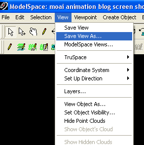
2) Pick a Point
When you figure out what will be the focus of your animation, pick a point that will be the center with Cyclone’s Seek Mode tool.
Save a “view” (located in the drop-down menu “View”, under “Save View”) with this point as the center.
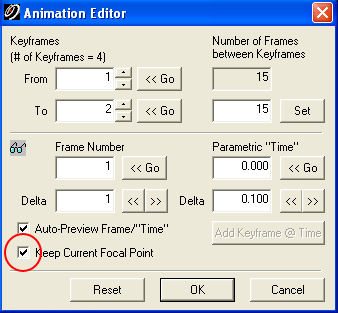
By doing this, you will always be able to reference this point, even when you pan through the modelspace. With simple, rotating animations, it is best to always check the box “Keep Current Focal Point” in the Animation Editor window.
This will ensure that your animation will have a smooth gliding effect and will also keep the focus of the animation on the point that you selected. Note that this, however, may not be the desired result if your video is traversing a site as it may then cause unintentional camera-angle changes.
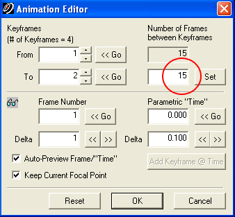
3) Frames
Make the number of frames between key points a multiple of 15. Exporting the animation as a 15fps movie will make the movie smooth and consistent. Keep in mind that the spacing of Key Points will affect the amount of frames needed between them; e.g., if you want two seconds between the key points indicated, then 30 frames will be needed.
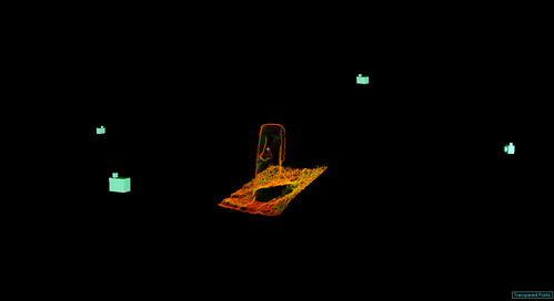
4) Number of Cameras
The number of cameras used in your animations will depend on the size of the modelspace. But a good number should be 4-15 cameras. If you have more, or less, than it is possible that the animations are too complicated, or not enough. In either case, the animation may become bumpy or uncontrolled. Here we see a Moai from Rapa Nui (Easter Island) with 4 cameras located around the monument to create a simple fly-around animation.
5) Animation Sequence Length
If you desire long and/or complex animations, then it is best to create several short animations with these tips and then merge the individual, short clips together in a separate video editing program. This provides greater video editing ability in a second program more suited to video production; these aditional editing abilities would include options such as fades, transitions and title sequences. The short videos are also easier and less time-consuming to generate within Cyclone.
Agencies have launched social networking applications at such a fast pace that government officials said on Friday that they plan to add more applications, such as Apple’s popular media store iTunes and the career-networking site LinkedIn.
The government also is negotiating agreements with social publishing site Scribd and commenting platform Intense Debate, said Martha Dorris, acting associate administrator for the General Services Administration’s Office of Citizen Services and Communications. The federal government has signed modified terms of service agreements to allow agencies to use social media sites Flickr, Facebook, YouTube, Vimeo, Slideshare and AddThis, among others.
The response to the agreements has been excellent, Dorris said. Agencies have set up Facebook profiles, Twitter accounts and YouTube channels to share information with the public. “We’re looking at taking information wherever citizens go to get information,” she said, adding GSA will consider adding more social networking sites, depending on requests from agencies.
Sheila Campbell, team leader of best practices for USA.gov and co-chairwoman of the Federal Web Managers Council, said tools such as Twitter offer the government the ability to communicate with the public very quickly in times of emergency. She cited as examples the Center for Disease Control and Prevention’s use of social media during its peanut recall and the swine flu outbreak.
Despite the common perception that social media tools are used mostly by younger users, baby boomers are the fastest-growing segment of users for most applications, according to Dorris. She said agencies were inspired by President Obama’s use of new media tools during his campaign and by WhiteHouse.gov, and have applied those lessons to outreach programs.
“Government needs to provide services and information the way the public wants it,” Dorris said. “One way is to engage the citizen, get an understanding of what they want. Give them a chance to be part of the decision-making in a way they never have before.”
When asked how agencies can move beyond simple broadcast of information to using social media to collect feedback, Dorris said Obama’s recent request for public input to support his open government initiative is an example. She said requests for public comments on health care and the recovery act were other examples.
“Let the public rate comments,” Dorris said. “Then take the issues, rated and ranked and look at the top 10. I think there’s a value to that externally and internally to solicit comments and feedback within your organization.”
The Federal Web Managers Council is working with agencies to craft policies for using social media tools, but the rules aren’t likely to be much different from existing guidelines on releasing information publicly, according to Campbell. “I think the same rules and ethics apply,” she said. “If you’re on Twitter, you shouldn’t be posting confidential information, just as you wouldn’t if speaking at a conference.”
GSA general counsel Seth Greenfield said any new social media policies would only complement existing ethical standards and regular use policies being applied to the use of IT.
https://scanable.com/wp-content/uploads/2025/01/SCANable_logo_emblemSimple-180x180.png00Travis Reinkehttps://scanable.com/wp-content/uploads/2025/01/SCANable_logo_emblemSimple-180x180.pngTravis Reinke2009-05-27 15:39:412009-05-27 15:39:41As social media becomes a hit with agencies, GSA plans more offerings

 BY THOMAS MAIER | thomas.maier@newsday.com
 Note: Hexagon Metrology is owned by Hexagon AB Group which also ownes Leica Geosystems. It will be interesting to see if any of this functionality will end up in Cyclone.
 Source:
  By Adam Sheppard