Tonight an email went out from Paris Marshall’s office stating the following:
“The General Services Administration (GSA) has completed its review of initial proposals submitted in response to the subject solicitation for the National 3D Laser Scanning Services project. This is to advise you that your proposal was evaluated as being one of the most highly rated, and your firm has been selected for an interview in connection with this procurement.”
Short-listed firms will be interviewed the week of August 10, 2009. Still no word on the number of firms on the short-list. If anyone knows, please post here.
https://scanable.com/wp-content/uploads/2025/01/SCANable_logo_emblemSimple-180x180.png00Travis Reinkehttps://scanable.com/wp-content/uploads/2025/01/SCANable_logo_emblemSimple-180x180.pngTravis Reinke2009-07-27 23:18:272009-07-27 23:18:27GSA Nationwide Laser Scanning Services – Phase II Interviews Week of August 10, 2009
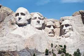
Officials have announced a project to digitally preserve Mount Rushmore National Memorial as part of an international project digitally preserving World Heritage Sites and monuments. Attending the announcement Friday were, from the left, Michael Russell, Scottish Culture Minister; Ben Kacyra of CyArk, a nonprofit organization, and; Gerard A. Baker, Mount Rushmore superintendent. NPS photo by Steve McEnroe.
Mount Rushmore officials are partnering with CyArk – a U.S.-based non-profit organization that pioneered the digital preservation (3d laser scanning, modeling and archiving) ofWorld Heritage Sites and monuments, – and the Culture Minister of the Scottish Government. The partnership’s task is the 3D digital recording of Mount Rushmore. This project is expected to provide, for the first time, a visual documentation of this internationally important memorial in South Dakota.
“We have discussed a commitment to pursue a truly pioneering partnership with CyArk and through them, the Scottish Government, RESPEC Engineering, Wyss and Associates, and the South Dakota School of Mines and Technology, to take advantage of truly innovative opportunities in digitally recording, preserving and managing our historic resources,” explained Gerard Baker, the memorial’s superintendent.
“While Mount Rushmore is a national icon in the U.S., there is expertise in other countries which can assist us to preserve it in a modern context. Therefore, we have identified international partners with technical expertise and commitment who share our vision to expand Mount Rushmore’s and the National Park Service’s ability to offer more interactive interpretive, educational and research programs while enhancing our preservation and security capabilities.
“A partnership of the size allows us to celebrate our cultural heritage on a world-wide stage by recording one of America’s most important historical sites for the benefit of future generations.”
The partners are now seeking to complete an agreement to share other expertise, explore further international collaboration, and develop cultural connections between Scotland and the United States.
“Scotland has great expertise and a wealth of experience in preserving, understanding and researching its historic environment,” said Michael Russell, Scotland’s minister for culture. “We have embraced 3D scanning to increase our awareness and are now able to share our knowledge in digital documentation with countries and organizations on a world stage for everyone to enjoy.
“This is a first step in what I believe can be a successful long term international partnership.”
CyArk is the brainchild of Ben Kacyra, whose foundation seeks to digitally capture a lasting record of such World Heritage sites as Mesa Verde, Pompeii in Italy, Ancient Thebes in Egypt, Tikal in Guatemala, Chichen Itza in Mexico, and Angkor in Cambodia, to list but a few.
“It was exciting to meet Superintendent Baker and his staff last fall and to learn of his vision of digitally preserving this American Icon for future generations,” Mr. Kacyra said Friday during a press conference. “His further objective of making this invaluable data available to the public worldwide aligned with CyArk’s mission of dissemination through the CyArk website.
“We are indebted to Historic Scotland for their very generous donation of resources and technology to perform the 3D-laser documentation. This underscores the international importance of Mount Rushmore and Scotland’s world-class capabilities in this field. We are delighted to have Mount Rushmore and Historic Scotland as active partners in CyArk and to have the memorial as one of the first heritage sites to be included in the CyArk 500.”
The scanning project will be led by CyArk with technical and logistical support through Historic Scotland – Scotland’s heritage agency and its partner, Glasgow School of Art – which will work with the Park Service at Mount Rushmore and devise a scanning timetable. The project is expected to begin in late September and be completed in two weeks.
Local technical partners RESPEC Engineering, Wyss and Associates, and the South Dakota School of Mines and Technology will benefit from the partnership by developing capabilities from shared experience to sustain and further develop this unique method of digitally visualizing and understanding the memorial and other historic landmarks.
The Mount Rushmore scanning project would provide a three-dimensional, digital model capable of recreating sculpted surfaces with an accuracy of less than 1 centimeter. This 3-D model will be the focus of the comprehensive CyArk website for showcasing to the public the heritage and historic assets contained within the memorial boundary.
The value of the 3-D model provides realistic digital information of the site and has applications to provide innovative and interactive public interpretation, education, research and security programs. Regarding the partners’ mutual goals of preserving this site, in the event of an incident resulting in damage to the sculpture, the model would provide the data necessary to accurately replicate carved surfaces.
The digital model will also give the Park Service the ability to develop a very realistic interactive model for Mount Rushmore for education and interpretive use including potential “virtual tours” of the memorial, as well as the entire site; the 3D models of the sculpture and the site could be used to create 3D digital educational programs for grades K-12.
Mount Rushmore’s Hall of Records represents a “time capsule” displaying all phases of the carving process. The digital model will capture this information with millimeter-scale accuracy for posterity and provide a means to share this unique information, educationally and interpretively, with individuals not able to visit the site.
https://scanable.com/wp-content/uploads/2025/01/SCANable_logo_emblemSimple-180x180.png00Travis Reinkehttps://scanable.com/wp-content/uploads/2025/01/SCANable_logo_emblemSimple-180x180.pngTravis Reinke2009-07-05 19:23:522009-07-05 19:23:52CyArk to Digitally Map Mount Rushmore National Memorial
Our industry never comes short in the innovation department. HKS Inc., headquartered in Dallas, Texas, proves this—it’s turned “regular” point clouds into game-engine quality. Here’s the story. And then read on for some amazing display solutions.
HKS, Inc.’s Pat Carmichael, manager of the Advanced Technology Group, began investigating point cloud scans as a way to achieve high-quality as-built information for the company’s architectural geometry applications used for schematic design (most often Revit). The team realized many benefits using laser scan data, including the ability to obtain data not manually possible, draw while acquiring field data, gain highly accurate data comparable to total station data, and to collect immense amounts of data in rapid time. Point clouds are the bread and butter of rapid model acquisition, Carmichael said in his presentation at SPAR 2009.
HKS scan data captured from subcontractors’ scanners are used in HKS’ home-grown product called BIMMIT, an evolving spin-off product from their real-time game-engine product ARCHengine that has been in development for more than 10 years and that which enhances Revit models. BIMMIT is usually coupled with HKS’ proprietary ARCHengine for real-time display of the resulting 3D BIMMIT/Revit models, which can be between 8 million to 30 million polygons depending on their use on a laptop or desktop.
To illustrate the awesomeness of this melding, consider the W hotel in Dallas. The final model of the pre-constructed hotel designed by HKS was used to show city officials how the hotel’s sight lines would affect the downtown skyline so valued by the city. It was also used to sell out the associated condos prior to construction, as developers could take prospective buyers virtually up to their windows to show the views from their units. This same concept was used for the Ritz-Carlton twin towers in downtown Dallas; the presentation helped to pre-sell approximately 85% of the Phase One units in about six months—even in this down market, Carmichael said.
HKS used aerial lidar from the city to set elevations, some of which are photographically textured. HKS also flies with a RED ONE digital camera, which shoots in 4K resolution, whereby they extract high-resolution textures rapidly for application with the aerial lidar geometry. Most of the building models come out of Revit.
With these incredible design tools, HKS also performed a design review on the seating in the new American Airlines sports arena. HKS showed staff, team owners and other investors how seats would articulate and rise for a hockey or basketball arena and specifically how they would affect viewlines. On the new Dallas Cowboys Stadium in Arlington, Texas, HKS took the collected field scan data, structural data and drawing data—and all site views from all 89,000 seats, scoreboards, etc., into ARCHengine. To check the models during construction, HKS used a total station to get information from point to point. In the desktop models of the ARCHengine tools, everything is georeferenced with lat/long/elev, which gives the team dimensional data.
“It’s a serious design tool,” Carmichael said. “It’s a serious communication tool to the clients/users/vendors, all the other suppliers, and a bunch of other people participating in the design process.”
Carmichael says the next version of ARCHengine version 3 will tie individual objects to a reporting structure, in line with 4D business strategies that tie in time, space calculations and scheduling. He said HKS Advanced Technology Group is also working with Intel on the high-end multi-processors to be able to react more quickly to a cluster of cores for simulations.
Those involved in sports stadium, government, military or GSA work will be interested in HKS’ Advanced Technology Group solutions.
To see an interactive map of the seats in the new Dallas Stadium with panoramic images generated from ARCHengine, click tohttp://www.dallascowboys.com/tickets/newstadiumInteractiveMaps.cfm
Digital Imaging, Holographic Style
Zebra Imaging, Inc., provider of holographic display technologies, has taken visualization of LiDAR and laser scan data sets to a new level. Users in the geospatial, AEC, automotive, medical, oil & gas, military and other arenas can view a topographical data set in full parallax, full color and without any glasses or goggles. “Seeing LiDAR and laser scanned data volumetrically expands its utility and value,” said Michael Klug, Zebra’s CTO, at this year’s SPAR 2009. Government and commercial uses seem endless.
Zebra’s solution graduates a physical display to digital holography by reconstructing a 3D image in space using film-based displays and illumination. The 12-year-old company founded by graduates of the Massachusetts Institute of Technology’s Media Lab has cut its teeth by aiding the military and law enforcement with displays that assist planning and after-action efforts, situational awareness and training.
It’s pretty cool stuff—a far, FAR cry from the hologram stickers I collected as a little girl. Klug describes the process as being more like burning data to a disc rather than a printing process. From a pair of GeoTiffs (one being a DEM, the other a geotextured map), Zebra’s proprietary Imager burns the pattern into photopolymer film with intersecting laser beams and produces an A1-size (594 × 841 mm) monochrome hologram that can be produced in CAD, GIS, medical imaging, oil & gas, etc., formats in 1-millimeter hogel size—about a pixel. Process time is about three hours. An average A1-size monochrome (green) hologram costs about $2,500. Full color and replication is available, and Klug says high-speed development will be available by Q4. Klug claims Zebra’s solution is similar or lower cost compared to other market alternatives today, and that it is more transportable and usable with full solid parallax 3D.
Zebra has produced more than 6,000 LiDAR-based holographic displays for military use in Iraq and Afghanistan since 2006. The 2×2 ½-foot maps provide warfighters with a common communication tool to get a common operating picture of an area of interest without language or cultural obstacles. Klug said they’re easily transportable and durable and, later, shreddable. Focus on AEC Market
In the last two years, the company has developed a new product line for the AEC realm. Attention focuses on geospatial context and all phases of design, BIM documentation, and communications and marketing.
Currently, Zebra is defining a styles guide and a CAD tool API plug-in-based interface available from a drop-down menu in Revit, 3DS Max and Google Sketchup (at first, then others). Klug says the creation of a wizard is a bit complicated for Zebra since they render with in-house tools to manage 64,000 to a quarter-million views of a scene within two hours. So, they’ve created a render-quality selection where the user can select a point cloud, a simple-shaded rendition of a data set, a textured data set or a photo-real selection (which customizes the job). Orders are returned in A-frame and horizontal format (each of which delivers different results) and include a lighting component. The Creation of Dynamic Displays
In 2004, Zebra was sponsored by DARPA to create a program for dynamic 3D displays for interactive graphic-intensive applications. The dynamic displays would be easy to view, have 360-degree visibility, be electronically updated in real-time, be modular and scalable to 6×6 feet, and offer horizontal, vertical and inclined orientations. To date, they’ve established a 1-meter diagonal prototype modular display of 8-inch square tiles with an image volume that occupies about 1 foot of space. It directly plugs into OpenGL-based applications and updates at 10 Hz. Pilot production and beta phase of this display is expected next year. Klug said any rendering feature a user can see on a 2D screen can be produced in the hologram, including translucency, transparency, reflection, etc.
Uses for these displays include, but don’t appear to be limited to, spatial, project and industrial process planning, land development, event security logistics, emergency management, heritage preservation, forensics presentation and construction progress monitoring.
https://scanable.com/wp-content/uploads/2025/01/SCANable_logo_emblemSimple-180x180.png00Travis Reinkehttps://scanable.com/wp-content/uploads/2025/01/SCANable_logo_emblemSimple-180x180.pngTravis Reinke2009-06-22 14:43:302009-06-22 14:43:30Too-cool technologies: Game Engine-quality Point Clouds and Digital Holography
Officials at Mount Rushmore National Memorial have added new tools in the constant effort to preserve the national icon.
While crews traditionally use silicone sealant, fracture-mapping techniques and other technology to preserve the faces, they have added laser scanning and digital mapping to tools use to keep the 68 year old in good condition.
Duane Bubac, director of cultural resources and facilities at Mount Rushmore National Memorial, said the mapping project will give the National Park Service detailed information about the features of Mount Rushmore. And the data could later be used to create virtual, up-close tours of Mount Rushmore.
In the past, maintenance was mostly a once-a-year event. Each fall, rope-access crews descended from the top of the memorial to inspect the granite and caulk the surface cracks. The fall maintenance work still takes place every September, Bubac said, but it’s now part of a much larger, year-around effort to monitor and preserve Mount Rushmore National Memorial.
“The process involves a lot more than sealing cracks now,” Bubac said.
Under the National Park Service long-range preservation plan, crews are fracture-mapping and crack-mapping the granite surface. They are also removing vegetation, cleaning and sealing cracks, removing hazard rocks and testing the next generation of sealant materials.
Mount Rushmore’s biggest threat is water. It seeps into cracks, freezes and expands. That freeze-thaw cycle could eventually degrade the surface of the granite. Dirt and vegetation could also be a threat. If dirt can accumulate in a small hollow, it gives opportunist weeds, bushes or trees the foothold they need to take root.
https://scanable.com/wp-content/uploads/2025/01/SCANable_logo_emblemSimple-180x180.png00Travis Reinkehttps://scanable.com/wp-content/uploads/2025/01/SCANable_logo_emblemSimple-180x180.pngTravis Reinke2009-06-02 10:46:322009-06-02 10:46:32Mount Rushmore to add laser scans, digital mapping in preservation efforts
In October 2006 I was sitting in my office at Microsoft trawling through a backlog of email and voice messages. It had been a busy couple of months leading up to the Technology Preview of Photosynth at San Francisco’s Web 2.0. We’d brought the house down with our on stage demonstration of Photosynth’s ability to take a large number of digital images and automatically assemble them into a high resolution, 3D environment that anyone could explore at home from within their web browser.
Around the same time, Chris Kemp (Currently CIO at NASA Ames) had just joined the Agency and was leading their business development efforts to seek out new and emerging technologies coming out of the private sector that could help NASA’s mission. He had seen the Photosynth demo and was eager to learn more about what he’d seen. He was full of ideas and saw the potential for Photosynth to bring the public closer to the space program than they had ever been before. They could follow in the tracks of the Mars Rovers, see every nut and bolt of a shuttle on the launch pad and experience first hand life onboard the International Space Station (ISS). At Microsoft Live Labs we were bringing some of the top computer scientists in the world together with talented engineers to explore new ground on the web. We couldn’t have asked for a more kindred spirit than the men and women of NASA who, through their own genius and engineering skills, were exploring our universe for the benefit of mankind.
Throughout 2007 we began planning and experimenting with images provided by NASA. Together with Microsoft Researcher Drew Steedly (one of our lead scientists on Photosynth) we visited Kennedy Space Center as preparations were underway for Shuttle Endeavor STS-118’s mission to the ISS. Chris had arranged unprecedented access to for us to photograph and document the Shuttle as tiles were being replaced, in the Vehicle Assembly Building, and on the launch pad itself. We were really eager to get some aerial shots of the shuttle awaiting launch, and Drew was lucky enough to sit with a SWAT team in one of those ‘Men In Black’ NASA helicopters as they flew a security fly-by around the shuttle on the pad, producing some amazing 360 degree shots we would later include in the synth. (video)
For the launch itself, we sat with the families of the astronauts, and one couldn’t help but remember the footage of the Apollo missions with people watching from the same bleachers as their loved ones journeyed to the Moon. A few days later, back in Seattle, we were proudly sharing our unique stories with our colleagues, when a call came in that had us jump into action. Since the Columbia tragedy occurred three years prior, many new safety procedures were instituted to help ensure the safety of the crew. One such measure was the detailed inspection of the underside of the shuttle from the ISS using both photography and a laser scan to assess any potential damage. Some damaged tiles had been found on Endeavour while in orbit and NASA was scrambling to make a decision on whether they should attempt a repair. During our previous discussions with NASA engineers, the idea of using Photosynth for safety procedures had been discussed and this was the perfect test case for us. Each tile is unique, carefully cut and individually serial numbered before being adhered by hand to the underside of the vehicle. Typically a specialist would have to trawl through thousands of close up images, cross-referencing against plans to visualize where on the shuttle the particular tile was. To help the specialists, we took all the images downlinked from the ISS while it was still in orbit, and used Photosynth to reconstruct the bottom of the shuttle, automatically placing the images together. We were all amazed at the results as we zoomed into the damaged tile. And while the decision had already been made to proceed without a repair, the value of this new technology had certainly been demonstrated.
Shortly afterwards I found myself at NASA headquarters in Washington DC demonstrating the synths to the Associate Administrator for Space Operations, William H. Gerstenmaier. He immediately saw the potential to share life onboard the ISS using Photosynth, and we soon found ourselves on our way to NASA’s Johnson Space Center in Houston to help train the astronaut on creating a full-size synth of the International Space Station. (video)
As we worked with the astronaut trainers, we soon realized that there were some unique challenges to consider in zero gravity. For example, Photosynth makes some assumptions on which way is ‘up’, but when you’re floating in space there is no ‘up’. With barely enough room to stand up, and every available space full of equipment, we also had to consider what technique would best capture both the panoramic views and detail shots that would lead to a successful synth. Towards the end of the day we got to meet some of the astronauts being trained on emergency procedures on a life-sized mockup of the Shuttle and finally had the chance to sit in a real Russian Soyuz capsule also used for training.
Needless to say it was my life long dream to be crawling through a space station and meeting the men and women who work tirelessly behind the scenes at NASA.
I personally moved on to other projects mid 2008, just when the flight plan for the new ISS Photosynths was coming together. All I can say is the resulting synths have turned out better than I could have ever imagined. I’m delighted to think that somewhere there’s a child exploring them right now who will one day walk on the surface of the Moon or even Mars.
https://scanable.com/wp-content/uploads/2025/01/SCANable_logo_emblemSimple-180x180.png00Travis Reinkehttps://scanable.com/wp-content/uploads/2025/01/SCANable_logo_emblemSimple-180x180.pngTravis Reinke2009-06-02 09:04:402009-06-02 09:04:40NASA Uses Laser Scan Data and Photosynth to Evaluate Shuttle Damage
Agencies have launched social networking applications at such a fast pace that government officials said on Friday that they plan to add more applications, such as Apple’s popular media store iTunes and the career-networking site LinkedIn.
The government also is negotiating agreements with social publishing site Scribd and commenting platform Intense Debate, said Martha Dorris, acting associate administrator for the General Services Administration’s Office of Citizen Services and Communications. The federal government has signed modified terms of service agreements to allow agencies to use social media sites Flickr, Facebook, YouTube, Vimeo, Slideshare and AddThis, among others.
The response to the agreements has been excellent, Dorris said. Agencies have set up Facebook profiles, Twitter accounts and YouTube channels to share information with the public. “We’re looking at taking information wherever citizens go to get information,” she said, adding GSA will consider adding more social networking sites, depending on requests from agencies.
Sheila Campbell, team leader of best practices for USA.gov and co-chairwoman of the Federal Web Managers Council, said tools such as Twitter offer the government the ability to communicate with the public very quickly in times of emergency. She cited as examples the Center for Disease Control and Prevention’s use of social media during its peanut recall and the swine flu outbreak.
Despite the common perception that social media tools are used mostly by younger users, baby boomers are the fastest-growing segment of users for most applications, according to Dorris. She said agencies were inspired by President Obama’s use of new media tools during his campaign and by WhiteHouse.gov, and have applied those lessons to outreach programs.
“Government needs to provide services and information the way the public wants it,” Dorris said. “One way is to engage the citizen, get an understanding of what they want. Give them a chance to be part of the decision-making in a way they never have before.”
When asked how agencies can move beyond simple broadcast of information to using social media to collect feedback, Dorris said Obama’s recent request for public input to support his open government initiative is an example. She said requests for public comments on health care and the recovery act were other examples.
“Let the public rate comments,” Dorris said. “Then take the issues, rated and ranked and look at the top 10. I think there’s a value to that externally and internally to solicit comments and feedback within your organization.”
The Federal Web Managers Council is working with agencies to craft policies for using social media tools, but the rules aren’t likely to be much different from existing guidelines on releasing information publicly, according to Campbell. “I think the same rules and ethics apply,” she said. “If you’re on Twitter, you shouldn’t be posting confidential information, just as you wouldn’t if speaking at a conference.”
GSA general counsel Seth Greenfield said any new social media policies would only complement existing ethical standards and regular use policies being applied to the use of IT.
https://scanable.com/wp-content/uploads/2025/01/SCANable_logo_emblemSimple-180x180.png00Travis Reinkehttps://scanable.com/wp-content/uploads/2025/01/SCANable_logo_emblemSimple-180x180.pngTravis Reinke2009-05-27 15:39:412009-05-27 15:39:41As social media becomes a hit with agencies, GSA plans more offerings


 Our industry never comes short in the innovation department.
 Source:
  By Adam Sheppard