Coign Asset Metrics & Technologies Awarded GSA Nationwide Laser Scanning Contract

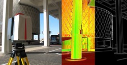
Pittsburgh, PA (PRWEB) October 30, 2009 — Coign Asset Metrics & Technologies (CoignAMT.com) announced today that it was selected for a five-year, $30 million, Indefinite Delivery Indefinite Quantity (IDIQ) contract awarded by the U.S. General Services Administration (GSA) Public Buildings Service (PBS). For this nationwide contract CoignAMT, as prime, and its partners will provide professional laser scanning and Building Information Modeling (BIM) services to each of the eleven GSA regions.

“We are very excited to be part of this monumental opportunity,”

CoignAMT is recognized for excellence with 3D Laser Scanning and Building Information Modeling
CoignAMT is recognized for excellence with 3D Laser Scanning and Building Information Models

“We are very excited to be part of this monumental opportunity,” said Travis Reinke, Asset Inventories Sector Manager for CoignAMT. “Our team is comprised of some of the most talented individuals in the laser scanning and building information modeling industries and we look forward to sharing our experiences utilizing the latest technologies and software to assist the GSA PBS in effectively managing their facilities for years to come. Having been involved in the laser scanning industry since the very beginning, it is exciting to not only see the rapid progression of the technology itself, but also the acceptance of its benefits in the architectural and federal community.”

This contract will support the new construction, renovation, and modernization initiatives of the GSA’s PBS central office and its eleven regional offices. Sites will likely involve federal offices, courthouses, border stations, laboratories, warehouse, and childcare facilities, among other types of real property. Services being provided by CoignAMT under this $6 million base year contract with four one-year options will include:

  • Documentation of facility interior and exterior conditions and systems utilizing 3D laser scanning
  • Transformation of point cloud datasets into BIM
  • BIM that encompass the facility life cycle (planning, design, construction, operations, maintenance, rehabilitation, and divestiture)
  • Subject Matter Expert support for architectural design; mechanical, electrical, and plumbing (MEP); and structural and civil engineering
  • Visual, geospatial and engineering analysis
  • Development of Best Practices relating to laser scanning, building information modeling and facility management
  • Business processes improvement through comprehensive facility life cycle management and expanded use of technology

CoignAMT President, Gary Sheets, stated, “Throughout the federal government and private sector, GSA Public Buildings Services is regarded as a leader in maximizing facility efficiencies through the application of advanced technologies. We are honored that GSA PBS has recognized our technical expertise, depth of experience and innovative solutions with this selection and look forward to supporting the GSA PBS with its laser scanning, BIM, and facility life cycle management initiatives nationwide.”

About the GSA PBS and the National 3D-4D-BIM Program: The landlord for the civilian federal government, GSA Public Buildings Service (PBS) acquires space on behalf of the federal government through new construction and leasing, and acts as a caretaker for federal properties across the country. PBS owns or leases 8,600 properties, maintains an inventory of more than 354 million square feet of workspace for 1.1 million federal employees, and preserves more than 480 historic properties.

In 2003 the General Services Administration (GSA), through its Public Buildings Service (PBS) Office of Chief Architect (OCA), established the National 3D-4D-BIM Program. OCA has led over 30 projects in its capital program, and is assessing and supporting three dimensional (3D), four-dimensional (4D), and Building Information Modeling (BIM) applications in over 35 ongoing projects across the nation. The power of visualization, coordination, simulation, and optimization from 3D, 4D, and BIM computer technologies allow GSA to more effectively meet customer, design, construction, and program requirements. GSA is committed to a strategic and incremental adoption of 3D, 4D, and BIM.


About Coign Asset Metrics & Technologies LLC:
Coign Asset Metrics & Technologies, LLC (CoignAMT) is a HUBZone qualified, SBA certified, small business that provides a full range of asset management life cycle services and specialized technologies, including high definition laser scanning (HDLS). Its mission is to strengthen public and private sector organizations by aligning their assets and operational practices with their strategic initiatives. CoignAMT is headquartered in the Pittsburgh, PA area, with regional offices located in Colorado Springs, CO, and Houston, TX. Clients include federal, state, and local governments, as well as private sector customers in the construction, energy, transportation, manufacturing, and security industries.

For more information, contact:
Travis Reinke, Asset Inventories Sector Manager
Phone: 888.600.5849 ext 3

www.CoignAMT.com

www.twitter.com/CoignAMT

Quantapoint Announces Integration of 3D Laser Scan Data With Autodesk(R) Revit(R)

PITTSBURGH, PA — (Marketwire) — 10/29/09 — Quantapoint (http://www.quantapoint.com) — recent recipient of a General Services Administration (GSA) laser scanning IDIQ contract — announced the integration of Quantapoint 3D laser scan data with Autodesk® Revit using QuantaCAD(TM). Laser data may be accessed directly within Revit as photo-realistic Laser Images(TM) of individual 3D laser scans and high-definition Laser Models(TM) of integrated laser data, not fuzzy “point clouds” whose sparse measurements make them difficult to use and understand.

“One of the challenges of Building Information Modeling (BIM) has been creating 3D BIM models that accurately represent existing buildings,” said Eric Hoffman, Founder of Quantapoint. “By integrating Laser Models and Laser Images with Revit, Quantapoint can more quickly create 3D BIM models and validate their accuracy. Additionally, new 3D BIM designs can be viewed and clashed with the laser data to ensure that they will fit into the existing facility, thus eliminating rework.”

QuantaCAD provides a number of useful capabilities to Revit users to enable them to create and validate 3D BIM models, visualize proposed modifications for design and constructability reviews, and identify and correct potential interferences. Some of the capabilities include:

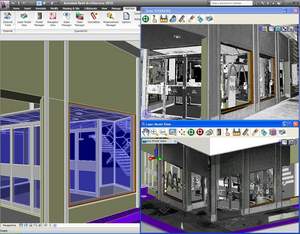
  • Direct Integration: Integrate laser data with Revit directly, without sub-sampling or converting to “polygon meshes.”
  • Laser Models: Display 3D BIM models using solid, high-definition
  • Laser Models for direct remodeling or to create new designs.
  • Laser Image Projection: Project 3D BIM models into Laser Images of individual 3D laser scans for real-time validation or design reviews.
  • Measurement: Measure points, distances and mechanical or plumbing pipe information between the 3D BIM model, Laser Images and Laser Models.
  • Clashing: Clash laser data and 3D BIM models to verify remodeling accuracy or identify interferences with new designs.
  • Demolition: Group Laser Models that are parts of the facility being demolished and highlight or hide them for planning or design analysis.
  • Multi-user Database: Share measurements across the team via a multi- user database to ensure consistent information and easier interactions.
  • State Manager: Store and recall laser data (Laser Models, Laser
  • Images and views) to focus on areas or interest and more quickly resume work.

By using QuantaCAD to put reality in Revit, BIM remodeling time can be reduced while ensuring accuracy, design time can be decreased by accessing complete and clear Laser Models and Laser Images that represent existing conditions, and rework from design clashes can be eliminated by correcting clashes between the Laser Models and the new design.

If you are interested in finding out more about accessing laser data in Revit using QuantaCAD or would like a demonstration, visitwww.quantapoint.com/qp/contact or e-mail info@quantapoint.com.

About Quantapoint

Quantapoint uses patented laser scanning technology to create a high-resolution Digitized Facility(TM) of Laser Models(TM) (not “point clouds”) and Laser Images(TM) that can be accessed directlywithin various CAD packages or integrated with facility and asset information. By putting critical facility as-built information at our client’s fingertips, Quantapoint has helped them reduce costs, optimize schedules, increase quality and improve safety. For more information on our technology and services, please visit www.quantapoint.com, e-mail info@quantapoint.com or call +1-412-653-0100.

Image Available: http://www2.marketwire.com/mw/frame_mw?attachid=1101374

Add to Digg Bookmark with del.icio.us Add to Newsvine

For additional information, please contact:

James McGill
VP of Marketing
Quantapoint, Inc.
Telephone: 412-653-0100, x-200
E-mail: jmcgill@quantapoint.com

Autodesk Releases Subscription Advantage Packs with Ambercore Point Cloud Technology

Ottawa, Canada, Wednesday, October 28, 2009 – Ambercore is pleased to announce its point cloud technology has been incorporated into the release of AutoCAD® Civil 3D® 2010 and AutoCAD® Map 3D 2010, part of Autodesk’s Subscription Advantage Packs. These releases are the first products from Autodesk that incorporate Ambercore’s technology which provides valuable new functionality for importing and visualizing large point cloud data sets.

Point clouds are extremely large data sets with millions of points, and are typically created through the use of laser scanning, high-definition surveying, or LiDAR (Light Detection and Ranging). They provide accurate representations of existing conditions of terrain surfaces, roadways, bridges, and the interior or exterior of features of buildings.

Some common uses of LiDAR data in AutoCAD® Civil 3D® and AutoCAD® Map 3D include using the point cloud data to create DEMs and contour data, digitizing as-built features for design projects, visualizing power lines and surrounding vegetation for right-of-way management, and developing an understanding of the site context in site surveys.

The Ambercore point cloud technology within the AutoCAD® Civil 3D® 2010 and AutoCAD® Map 3D 2010 products enables customers to read, store, index, and quickly retrieve the extremely large point cloud data sets associated with laser scanning and LiDAR. As a result, customers are able to visualize and analyze data in 3D and better build high-precision 3D models.

“The point cloud technology from Ambercore allows Autodesk AEC customers to easily incorporate extremely large and highly accurate LiDAR data into their infrastructure design and management processes,” said Charlie Crocker, Infrastructure Product Line Manager, Autodesk AEC (Architecture, Engineering, and Construction) solutions. “The incorporation of this technology into AutoCAD Civil 3D and AutoCAD Map 3D software means that our customers will be able to better plan, design, and manage infrastructure projects.”

“We are very excited about the first release of our technology within Autodesk’s AutoCAD® Civil 3D® and Map 3D products,” said Ted Reeler, Director, Projects & Technology at Ambercore. “We are confident that this new functionality for point clouds will be a significant asset to their customers, and we look forward to our ongoing collaboration with Autodesk.”

About Ambercore
Ambercore is the 4D Company. We make innovative mobile LiDAR technology, we provide LiDAR data collection services, and integrate and extract knowledge from 4D data. Ambercore’s 4D-iQ provides enterprise-scale software and service solutions for Energy, Mining and natural resource sectors. With its powerful spatial modeling and simulation software, 4D-iQ helps clients make important business decisions by collecting, integrating and analyzing spatial information in 2D, 3D and in 4D (over time).

TITAN® is a revolutionary technology that produces high accuracy survey and mapping products for corridor and infrastructure projects across a number of vertical markets. Travelling at highway speeds – or on rail or vessel – the system uses state-of-the-art LiDAR, imaging and positioning technology to provide feature rich 3-dimensional data, from which intelligent information is extracted and delivered to clients. TITAN® has been deployed on projects throughout the world since 2003.

Ambercore’s Terrapoint Division has provided LiDAR and other digital mapping services for a diverse clientele in over forty countries for the past twenty years. Terrapoint’s primary focus is to find solutions that fit client needs, and to continue a reputation for meeting and exceeding client demands in the delivery of digital elevation and image data. Service and product offerings include complete airborne LiDAR, and digital imaging for engineering, survey and mapping applications. Terrapoint is considered a leader in aerial LiDAR services, and owns one of the largest fleets of sensors in the world. Best of breed solutions comprised of software, hardware and services have been deployed internationally with tier-one clients. Ambercore is headquartered in Ottawa, Canada with offices in Houston, Calgary, South Africa and Europe.

Trimble Develops Next Generation 3D Laser Scanner for Industrial Plant Applications

3D Laser Scanner Combines Phase and Time of Flight Technologies for Fast and Accurate Data Capture

SUNNYVALE, Calif., Oct. 29, 2009 — Trimble (NASDAQ: TRMB) introduced today the Trimble® CX 3D laser scanner with Trimble’s proprietary WAVEPULSE™ technology. WAVEPULSE combines the high short-range accuracy of phase-shift technology with the low-noise sensitivity and high-distance characteristics of time-of-flight technology. The result is high-precision measurements over the full operating range that provides the clean 3D data needed for industrial plant scanning applications—allowing the user to realize increased productivity and reduced operating costs. And by requiring fewer setups and enabling faster processing time in an industrial plant environment, the Trimble CX solution can contribute to improved worker safety.

Built for Efficiency in the Plant

The Trimble CX solution is built for efficient data capture in the plant. With reliable scanning at 50,000 points per second and an 80 meter range with a 360 degree x 300 degree field of view, the solution provides widespread and efficient data capture from a single setup. A rugged design, IP54 rating and protective housing for the rotating laser allow the scanner to deliver continuous and reliable results even in difficult industrial environments. An integrated camera collects additional image information that can improve the visualization, post-processing and communication of the captured data.

The Trimble CX is supported by Trimble Access™ software for Spatial Imaging, which runs on the Trimble Tablet rugged PC. Powerful and built for industrial conditions, the Trimble Tablet combines a large, daylight readable display, IP67 environmental rating and long battery life that can easily withstand the demands of plant environments. With intuitive and streamlined Trimble Access Software, capturing data with the Trimble CX requires a very short learning curve. Data can be seamlessly transferred to Trimble’s 3D scanning office software packages: Trimble RealWorks™ and Trimble LASERGen™ software.

Certified Application for Tank Measurements

The Trimble CX solution also includes 3D Extractor software specifically developed for storage tank calibration. The software can significantly reduce the time taken to calibrate storage tanks while also providing a richer data set that can be used for monitoring tank deformations. The Trimble CX is certified by the Physikalisch-Technischen Bundesanstalt (the German National Metrology Institute, PTB).

An Integral Solution for Plant Lifecycle Management

Managing a plant’s lifecycle requires a clear understanding of the location and condition of the plant’s assets. The Trimble CX 3D laser scanning solution can be used for a variety of industrial plant positioning applications:

  • Capturing existing condition data for accurate project planning for basic and detailed design;
  • Ensuring dimensions of fabricated parts prior to transportation and installation;
  • Verifying as-built construction for quality assurance and additional detailed design;
  • Visualizing real world conditions for training and simulation;
  • Monitoring plant assets and potential movement or deformation during use;
  • Planning retrofit construction projects based upon accurate data and;
  • Calibrating storage tanks by determining filling tables and sump volumes.

The Trimble CX is expected to be available in the fourth quarter of 2009.

About Trimble’s Power, Process and Plant Division

Trimble’s Power, Process and Plant Division provides a comprehensive range of positioning solutions to transform the plant lifecycle work process—from design and construction to ongoing operation and maintenance.Trimble’s 3D laser scanning hardware and software provides: increased productivity by delivering fast, accurate data with minimal impact to plant operations or project timelines; reduced rework by providing highly accurate existing condition data; and can contribute to improved worker safety through the fast acquisition of data when in the industrial plant environment. Trimble’s solutions are used in the oil & gas, power generation and manufacturing industries.

For more information about Trimble’s Power, Process and Plant solutions visit: www.trimble.com/plant.

About Trimble

Trimble applies technology to make field and mobile workers in businesses and government significantly more productive. Solutions are focused on applications requiring position or location—including surveying, construction, agriculture, fleet and asset management, public safety and mapping. In addition to utilizing positioning technologies, such as GPS, lasers and optics, Trimble solutions may include software content specific to the needs of the user. Wireless technologies are utilized to deliver the solution to the user and to ensure a tight coupling of the field and the back office. Founded in 1978, Trimble is headquartered in Sunnyvale, Calif.

Investor Relations Contact: Willa McManmonof Trimble: 408-481-7838
Media Contact: LeaAnn McNabb of Trimble: 408-481-7808

Leica Geosystems HDS Announces New 3D Laser Scanning Software

Leica Geosystems announces three new laser scanning software products for scan data import, forensic scene mapping, and modeling complex 3D surfaces. Combined, these products increase the breadth and depth of laser scanning software solutions available from Leica Geosystems.

A new, standalone Cyclone IMPORTER module is part of the separately announced, enhanced Cyclone 7.0 software suite. This new “open systems” module enables the direct use by Cyclone of scan data. Direct import of native data formats avoids conversion steps to neutral formats that can be time consuming and that are generally not as efficient for downstream data processing. Overall, it lets users of scan data from 3rd party scanners take better advantage of the broad capabilities in the Cyclone suite of software.

Cyclone IMPORTER module

ForensicMap Pro, developed by MicroSurvey, is available exclusively from Leica Geosystems. It builds on the strength of MicroSurvey’s existing software for mapping forensic scenes and incidents and takes advantage of Leica’s point cloud engine technology. With the addition of point cloud processing capabilities in mapping software specific for them, forensic professionals can now take further, direct advantage of the richness and completeness of 3D High-Definition SurveyTM data for forensic investigations, a high growth area for laser scanning.

Leica ForensicMap Pro software

3DReshaper software, a powerful, standalone software for working efficiently with large, complex meshes and comparing them against designmodels, has been added to the suite of point cloud processing software directly available from Leica Geosystems. Developed by Technodigit SARL, a Hexagon company, 3DReshaper enables users of laser scan data to create smooth surface models of very complex 3D geometry surfaces. This capability is especially useful for laser scanning applications involving heritage, archaeology, architecture, ship hulls, and terrain mapping among others. Hexagon is also the parent company for Leica Geosystems.

For more information please visit www.leica-geosystems.com/hds

UPDATE: GSA Nationwide Laser Scanning Services Contract Awards

GSAlogo

The General Services Administration (GSA), Public Buildings Services (PBS), has officially awarded six individual $30 million Nationwide Laser Scanning IDIQ Contracts to the following firms (source: https://www.fbo.gov/spg/GSA/PBS/PHA/GS-00P-09-CYD-0137/listing.html):

Some firms were awarded contracts in their specific region(s) and others were awarded a contract covering all of the GSA regions.

Congratulations to all! These firms include some of the most talented individuals in 3D laser scanning. It will be interesting to see how much work actually comes out of this contract and how it will impact the laser scanning industry. Be sure to follow us on Twitter to get the latest updates on this monumental contract award.

Quantapoint Awarded GSA Laser Scanning IDIQ Contract

PITTSBURGH, PA -- 10/07/09 -- Quantapoint (http://www.quantapoint.com) -- provider of laser scanning technology and services that provides precise facility as-built information for engineering analysis and a..PITTSBURGH, PA — 10/07/09 — Quantapoint (http://www.quantapoint.com) — provider of laser scanning technology and services that provides precise facility as-built information for engineering analysis and asset management — announced that it was awarded a General Services Administration (GSA) Laser Scanning Indefinite Delivery, Indefinite Quantity (IDIQ) contract. The IDIQ contract is for Quantapoint and its partners to provide laser scanning and related services for all GSA regions of the United States in support of Building Information Modeling (BIM), building modifications and performance upgrades such as Leadership in Energy and Environmental Design (LEED) certification. The contract has a maximum value of $30 million over five years.

Quantapoint’s unique combination of significant experiencebroad expertise and coverage of all GSA regions were major factors in the award. Quantapoint is one of the world’s most experienced laser scanning companies, having executed more than 1,400 laser scanning projects over 18 years in facilities ranging from historic structures and multi-story office buildings to refineries, nuclear power plants and offshore platforms. Quantapoint also has a broad range of laser scanning expertise, having created multiple generations of laser scanner hardware and viewing and analysis softwarethat have been used for projects around the world.

“Quantapoint originally developed the concept of 360 degree laser scanning to support the documentation of public buildings, so we are pleased that the GSA has decided to adopt laser scanning as an effective and accurate method of developing BIM for renovation and restoration projects,” said Eric Hoffman, Founder of Quantapoint. “We look forward to using our practical experience and technological expertise to help develop standards, work processes and best practices to advance the usage of laser scanning.”

Added John R. Wilson, Quantapoint’s President and CEO, “We are delighted that the US government have recognized Quantapoint’s leadership role in laser scanning by the award of this contract. We look forward to working with our partners to deliver value to the government and playing a significant role in the preservation and improvement of this county’s inventory of public buildings.”

Quantapoint’s Laser Scanning IDIQ team includes Martinez+Johnson Architecture; EMO Energy Solutions; Rolf Jensen & Associates; Protection Engineering Group; AMT Engineering; Hinman Consulting Engineers; Arnold Animations and Certainty3D.

For more information on laser scanning or related services, please contact Lisa Buff at +1-248-310-3200 or lbuff@quantapoint.com.

About Quantapoint

Quantapoint uses patented laser scanning technology to create a high-resolution Digitized Facility(TM) of Laser Models(TM) (not “point clouds”) that can be accessed directlywithin various CAD packages or integrated with facility and asset information. By putting critical facility as-built information at our client’s fingertips, Quantapoint has helped them reduce costs, optimize schedules, increase quality and improve safety. For more information on our technology and services, please visit www.quantapoint.com, e-mail: info@quantapoint.com or call +1-412-653-0100.

For additional information, please contact:

James McGill
VP of Marketing
Quantapoint, Inc.
Telephone: 412-653-0100, x-200
E-mail: jmcgill@quantapoint.com