As 3D laser scanning has become easier and more affordable it has become the technology of choice for ‘as-is’ data capture. LFM Server™ enables users to maximize the value of the rich information that laser scanning generates.
LFM Server is the most advanced solution available for accessing pre-registered laser scan data and working with it directly in 3D CAD systems. It is simple to use and offers unrivalled performance and functionality.
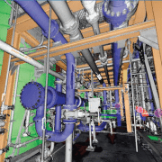
There are many different 3D laser scanners and 3D CAD systems in use today. LFM Server has been developed to provide users with maximum freedom of choice of both scanning and design systems. It can read unstructured data from various scanner types; not only terrestrial laser scanners but also hand-held, mobile or aerial scanners.
Designed to work with data from even the highest-resolution scanner, LFM Server enables users to work with datasets of unlimited size and exploit photorealistic, 360° BubbleViews™.
Business Benefits
Open on the input
LFM Server can read a wide variety of 3D data capture formats
Open on the output
LFM Server interfaces seamlessly with all leading 3D CAD systems
Unlimited Datasets
InfiniteCore™ technology enables project datasets of unlimited size to be readily created and accessed
Increased Productivity
The intuitive 360° BubbleView makes it easy to verify clashes, review laser scan data, or simply become familiar with the site
Clash-free Design
Accurate, detailed ‘as-is’ information minimizes the business risks of revamp projects
Business Flexibility
Import scans from a wide variety of scanner types and data formats into a single dataset
For more information about LFM Server 4.2’s great new features, contact us or read more here.
https://scanable.com/wp-content/uploads/2013/06/LFM-BubbleView-Hotspots.png413679Travis Reinkehttps://scanable.com/wp-content/uploads/2025/01/SCANable_logo_emblemSimple-180x180.pngTravis Reinke2013-06-20 21:19:072015-05-21 19:26:47LFM Server 4.2 – Introducing Key New Features
Leica Geosystems announces three new laser scanning software products for scan data import, forensic scene mapping, and modeling complex 3D surfaces. Combined, these products increase the breadth and depth of laser scanning software solutions available from Leica Geosystems.
A new, standalone Cyclone IMPORTER module is part of the separately announced, enhanced Cyclone 7.0 software suite. This new “open systems” module enables the direct use by Cyclone of scan data. Direct import of native data formats avoids conversion steps to neutral formats that can be time consuming and that are generally not as efficient for downstream data processing. Overall, it lets users of scan data from 3rd party scanners take better advantage of the broad capabilities in the Cyclone suite of software.
Cyclone IMPORTER module
ForensicMap Pro, developed by MicroSurvey, is available exclusively from Leica Geosystems. It builds on the strength of MicroSurvey’s existing software for mapping forensic scenes and incidents and takes advantage of Leica’s point cloud engine technology. With the addition of point cloud processing capabilities in mapping software specific for them, forensic professionals can now take further, direct advantage of the richness and completeness of 3D High-Definition SurveyTM data for forensic investigations, a high growth area for laser scanning.
Leica ForensicMap Pro software
3DReshaper software, a powerful, standalone software for working efficiently with large, complex meshes and comparing them against designmodels, has been added to the suite of point cloud processing software directly available from Leica Geosystems. Developed by Technodigit SARL, a Hexagon company, 3DReshaper enables users of laser scan data to create smooth surface models of very complex 3D geometry surfaces. This capability is especially useful for laser scanning applications involving heritage, archaeology, architecture, ship hulls, and terrain mapping among others. Hexagon is also the parent company for Leica Geosystems.
PITTSBURGH, PA — 06/15/09 — Quantapoint (http://www.quantapoint.com) — provider of laser scanning technology and services that help companies achieve Zero-Defect Projects™ — today announced that Quantapoint Laser Models™ may be accessed directly in Intergraph SmartPlant 3D using QuantaCAD 9.0. QuantaCAD enables 3D laser scan data to be accessed as high-definition Quantapoint Laser Models™ (not fuzzy “point clouds”) and photo-realistic Laser Images™ directly within design software.
QuantaCAD provides a number of useful capabilities to SmartPlant 3D users to enable them to compare and validate CAD models, visualize proposed modifications for design and constructability reviews, and identify and correct potential constructioninterferences. Some of the capabilities include:
-- Direct Integration: A separate "point server" is not required due to the smaller size of the Laser Models. -- State Manager: Store and recall the laser data state (loaded Laser Models, Laser Images and views) so users can quickly resume work instead of having to manually reload laser scan data. -- Tag Points: Create and edit tag points (specific 3D locations, such as tie points) directly in the laser data so users can access consistent design starting and ending points across the team. -- Clipping and Slicing: Clip laser data to temporarily hide view obstructions or slice it to create a section of laser data. -- Demolition: Demolish areas of the facility being removed in the laser data to remove it from view. -- Flexible Licensing: Quantapoint software are now integrated and may be licensed monthly for standalone or network usage, providing more flexibility based on project or program needs.
By using QuantaCAD to put reality on the desktop and in design software, clients have typically been able to reduce remodeling time by 85% (by using Laser Models instead of CAD remodeling or as a basis to remodel), decrease design time by 60% (by accessing more complete and clear Laser Models and Laser Images for design) and cut rework from design clashes by 85% (by correcting clashes between the Laser Models and the new CAD design). If you are interested in finding out more about accessing laser data in SmartPlant 3D using QuantaCAD 9.0 or would like a demonstration, visit www.quantapoint.com/qp/contact or e-mail info@quantapoint.com.
James McGill
VP of Marketing
Quantapoint, Inc.
Telephone: 412-653-0100, x-200
E-mail: jmcgill@quantapoint.com
https://scanable.com/wp-content/uploads/2025/01/SCANable_logo_emblemSimple-180x180.png00Travis Reinkehttps://scanable.com/wp-content/uploads/2025/01/SCANable_logo_emblemSimple-180x180.pngTravis Reinke2009-06-15 15:04:292009-06-15 15:04:29Quantapoint Announces Integration of Laser Scan Data Into Intergraph SmartPlant 3D(TM)
This is old news, but it is worth posting here for users thinking about purchasing point cloud software in the near future.
Ottawa, Canada, Tuesday, September 23, 2008 — Autodesk, Inc. has signed an agreement with Ambercore Software to license its point cloud technology and incorporate
it into future releases of Autodesk software. Point clouds are extremely large data files usually created through the use of laser scanning, high definition surveying, or LIDAR (Light Detection and Ranging). They provide a more accurate representation of existing conditions whether of a terrain surface or urban center, a roadway or bridge, or the interior/exterior of a building.
The Ambercore Software point cloud technology will enable customers to read, store, index, and quickly retrieve the extremely large data sets associated with laser scanning and LIDAR. As a result they will be able to visualize and analyze data in 3D and better build high-precision 3D models. Examples of customer benefits include:
• Local government, utility and telecommunications customers will be able to maximize the return on their investment in large-scale LIDAR mapping and infrastructure projects.
• AEC customers will experience the power of Building Information Modeling (BIM) earlier in the project lifecycle. By providing the capability to incorporate highly accurate LIDAR data into the design process, we will provide a foundation for creating more accurate designs faster. This will be particularly beneficial to our civil engineering customers involved in road and highway design.
“The point cloud technology from Ambercore Software will allow Autodesk customers to easily incorporate extremely large and highly accurate LIDAR data into the design and infrastructure management process,” said Lisa Campbell, vice president, Autodesk Geospatial. “The incorporation of this technology into Autodesk’s portfolio of Geospatial and Building Information Modeling software means that our customers will be able to start with a digital model earlier in the design process or expand the precision and detail of existing infrastructure databases. As a result they will be able to create more accurate design and mapping information and use that information to visualize, simulate, and analyze projects before they are built.”
“Ambercore’s point cloud software has been engineered to efficiently manipulate extremely large spatial data,” said Martin Sendyk, President and CEO of Ambercore Software. “With the increasing proliferation of 3D sensing equipment and resultant point cloud data, the ability to extract intelligence from massive 3D data sets is more important than ever. We are very excited to be solving this challenge with an innovative company like Autodesk.”
About BIM
BIM is an integrated process built on coordinated, reliable information about a project from design through construction and into operations. By adopting BIM, architects, engineers, contractors and owners can easily create coordinated digital design information and documentation; use that information to more accurately visualize, simulate and analyze performance, appearance and cost; and reliably deliver the project faster, more economically and with reduced environmental impact
About Autodesk
Autodesk, Inc. is the world leader in 2D and 3D design software for the manufacturing, building and construction, and media and entertainment markets. Since its introduction of AutoCAD software in 1982, Autodesk has developed the broadest portfolio of state-of-the-art digital prototyping solutions to help customers experience their ideas before they are real. Fortune 1000 companies rely on Autodesk for the tools to visualize, simulate and analyze real-world performance early in the design process to save time and money, enhance quality and foster innovation. For additional information about Autodesk, visit http://www.autodesk.com.
About Ambercore
Ambercore provides enterprise-scale software and service solutions for Energy, Mining and natural resource sectors. With its powerful spatial modeling and simulation software, Ambercore helps clients make important business decisions by collecting, integrating and analyzing 2D and 3D spatial information. Ambercore’s Terrapoint Division has provided LiDAR and other digital mapping services for a diverse clientele in over forty countries for the past twenty years. Terrapoint’s primary focus is to find solutions that fit client needs, and to continue a reputation for meeting and exceeding client demands in the delivery of digital elevation and image data. Service and product offerings include complete airborne LiDAR, and digital imaging for engineering, survey and mapping applications. Ambercore’s TITAN® Division develops leading edge mobile LiDAR systems for ground based high accuracy applications. Best of breed solutions comprised of software, hardware and services have been deployed internationally with tier-one clients. Ambercore is headquartered in Ottawa, Canada with offices in Houston, Calgary, South Africa and Europe. For more information please see www.ambercore.com
Ambercore, Terrapoint, and TITAN are registered trademarks or trademarks of Ambercore Software Inc., and/or its subsidiaries and/or affiliates, in the USA and/or other countries. All other brand names, product names, or trademarks belong to their respective holders. Ambercore reserves the right to alter product offerings and specifications at any time without notice, and is not responsible for typographical or graphical errors that may appear in this document.
Autodesk and AutoCAD are registered trademarks or trademarks of Autodesk, Inc., and/or its subsidiaries and/or affiliates, in the USA and/or other countries.
https://scanable.com/wp-content/uploads/2025/01/SCANable_logo_emblemSimple-180x180.png00Travis Reinkehttps://scanable.com/wp-content/uploads/2025/01/SCANable_logo_emblemSimple-180x180.pngTravis Reinke2009-06-12 11:13:262009-06-12 11:13:26Autodesk to Incorporate Point Cloud Capability in Future Releases of AutoCAD
ILoveSketch, a 3D curve sketching system that captures some of the affordances of pen and paper for professional designers, allowing them to iterate directly on concept 3D curve models. The system coherently integrates existing techniques of sketch-based interaction with a number of novel and enhanced features. Novel contributions of the system include automatic view rotation to improve curve sketchability, an axis widget for sketch surface selection, and implicitly inferred changes between sketching techniques. We also improve on a number of existing ideas such as a virtual sketchbook, simplified 2D and 3D view navigation, multi-stroke NURBS curve creation, and a cohesive gesture vocabulary.
https://scanable.com/wp-content/uploads/2025/01/SCANable_logo_emblemSimple-180x180.png00Travis Reinkehttps://scanable.com/wp-content/uploads/2025/01/SCANable_logo_emblemSimple-180x180.pngTravis Reinke2009-06-04 13:34:502009-06-04 13:34:50Great New Interface for Complex 3D Modeling

 Open on the input
 Open on the input