RIEGL_Software_RiALITY_Screen-5d

Introducing the World’s First App for LiDAR data visualization on the iPad: RiALITY

RIEGL proudly announces its new iPad point cloud viewer: RiALITY, now available for free in the iTunes App Store.

This new, innovative App, the first of its kind, allows users to experience LiDAR data in a completely new environment. It also allows easier LiDAR data demonstrations through the use of an iPad.

RIEGL’s RiALITY App enables users to visualize and navigate through point clouds acquired with RIEGL laser scanners. As an example, users are able to explore a dataset of the beautiful Rosenburg Castle in Austria. RIEGL scans can also be imported from RIEGL’s RiSCAN PRO software into the App, as well.

“We’re pleased to present a new way of visualizing point clouds. RiALITY delivers this new technology by providing Augmented Reality technology in an easy-to-use app. Now you can easily send your client a 3D point cloud that they can visualize on their iPad, for free.” said Ananda Fowler, RIEGL’s manager of terrestrial laser scanning software.

RiALITY features true color point clouds and 3D navigation. In a breakthrough technological development, the app features an Augmented Reality Mode. The Augmented Reality Mode allows point clouds to be virtually projected into the real world.

Dive into the point cloud!

Find out more at www.riegl.com/app.

LiDAR for Visual Effects - Rebirth

Krakatoa Creates CG Visual Effects from LIDAR Scans for Short Film “Rebirth”

Film director and cinematographer Patryk Kizny – along with his talented team at LookyCreative – put together the 2010 short film “The Chapel” using motion controlled HDR time-lapse to achieve an interesting, hyper-real aesthetic. Enthusiastically received when released online, the three-minute piece pays tribute to a beautifully decaying church in a small Polish village built in the late 1700s. Though widely lauded, “The Chapel” felt incomplete to Kizny, so in fall of 2011, he began production on “Rebirth” to refine and add dimension to his initial story.

LiDAR for Visual Effects - Rebirth

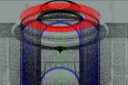
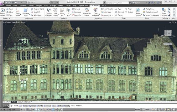
Exploring the same church, “Rebirth” comprises three separate scenes created using different visual techniques. Contemplative, philosophical narration and a custom orchestral soundtrack composed by Kizny’s collaborator, Mateusz Zdziebko, help guide the flow and overall aspirational tone of the film, which runs approximately 12 minutes. The first scene features a point cloud representation of the chapel with various pieces and cross-sections of the building appearing, changing and shifting to the music. Based on LIDAR scans taken of the chapel for this project, Kizny generated the point clouds with Thinkbox Software’s volumetric particle renderer, Krakatoa, in Autodesk 3ds Max.

LiDAR for VFX - Rebirth

“About a year after I shot ”The Chapel,” I returned to the location and happened to get involved in heritage preservation efforts,” Kizny explained. “At the time, laser scanning was used for things like archiving, set modeling and support for integrating VFX in post production, but I hadn’t seen any films visualizing point clouds themselves, so that’s what I decided to do.”

EKG Baukultur an Austrian/German company that specializes in digital heritage documentation and laser scanning, scanned the entire building in about a day from 25 different scanning positions. The collected data was then registered and processed – creating a dataset of about 500 million points. Roughly half of the collected data was used to create the visualizations.

3D Laser Scanning for Visual Effects - Rebirth

Data processing was done in multiple stages using various software packages. Initially, the EKG Baukultur team registered the separate scans together in a common coordinates space using FARO Scene software. Using .PTS format, the data was then re-imported into Alice Labs Studio Clouds (acquired by Autodesk in 2011) for clean up. Kizny manually removed any tripods with cameras, people, checkerboards and balls that had been used to reference scans. Then, the data was processed in Geomagic Studio to reduce noise, fill holes and uniformly downsample selected areas of the dataset. Later, the data was exported back to the .PTS ASCII format with the help of MeshLab and processed using custom Python scripting so that it could be ingested using the Krakatoa importer. Lacking a visual effects background, Kizny initially tested a number of tools to find the best way to visualize point cloud data in a cinematic way with varying and largely disappointing results. Six months of extensive R&D led Kizny to Krakatoa, a tool that was astonishingly fast and a fraction of the price of similar software specifically designed for CAD/CAM applications.

“I had a very basic understanding of 3ds Max, and the Krakatoa environment was new to me. Once I began to figure out Krakatoa, it all clicked and the software proved amazing throughout each step of the process,” he said.

Even with mixing the depth of field and motion blur functions in Krakatoa, Kizny was able to keep his render time to roughly five to ten minutes per frame, even while rendering 200 million points in 2K, by using smaller apertures and camera passes from a higher distance.

“Krakatoa is an amazing manipulation toolkit for processing point cloud data, not only for what I’m doing here but also for recoloring, increasing density, projecting textures and relighting point clouds. I have tried virtually all major point cloud processing software, but Krakatoa saved my life on this project,” Kizny noted.

In addition to using Krakatoa to visualize all the CG components of “Rebirth” as well as render point clouds, Kizny also employed the software for advanced color manipulation. With two subsets of data – a master with good color representation and a target that lacked color information – Kizny used a Magma flow modifier and a comprehensive set of nodes to cast and spatially interpolate the color data from the master subset onto the target subset so that they blended seamlessly in the final dataset. Magma modifiers were also used for the color correction of the entire dataset prior to rendering, which allowed Kizny greater flexibility compared to trying to color correct the rendering itself. Using Krakatoa with Magma modifiers also provided Kizny with a comprehensive set of built-in nodes and scripting access.

3D Laser Scanning for Visual Effects - Rebirth

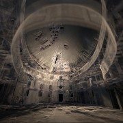
The second scene of “Rebirth” is a time-lapse reminiscent of “The Chapel,” while the final scene shows live action footage of a dancer. Footage for each scene was captured using Canon DSLR cameras, a RED ONE camera and DitoGear motion control equipment. Between the second and third scene, a short transition visualizes the church collapsing, which was created using 3ds Max Particle Flow with help of Thinkbox Ember, a field manipulation toolkit, and Thinkbox Stoke, a particle reflow tool.

“In the transition, I’m trying to collapse a 200 million-point data cloud into smoke, then create the silhouette of a dancer as a light point from the ashes,” shared Kizny. “Even though it’s a short scene, I’m making use of a lot of technology. It’s not only rendering this point cloud data set again; it’s also collapsing it. I’m using the software in an atypical way, and Thinkbox has been incredibly helpful in troubleshooting the workflow so I could establish a solid pipeline.”

Collapsing the church proved to be a challenge for Kizny. Traditionally, when creating digital explosions, VFX artists are blowing up a solid, rigid object. Not only did Kizny need to collapse a point cloud – a daunting task in of itself – but he also had to do so in the hyper-realistic aesthetic he’d established, and in a way that would be both ethereal and physically believable. Using 3ds Max Particle Flow as a simulation environment, Kizny was able to generate a comprehensive vector field of high resolution that was more efficient and precisely controlled with Ember. Ember was also used to animate two angels appearing from the dust and smoke along with the dancer silhouette. The initial dataset of each of angels was pushed through a specific vector noise field that produced a smoke-like dissolve and then reversed thanks to retiming features in Krakatoa, Ember and Stoke, which was also used to add density.

3D Laser Scanning for Visual Effects - Rebirth

“To create the smoke on the floor, I decided to go all the way with Thinkbox tools,” Kizny said. “All the smoke you see was created using Ember vector fields and simulated with Stoke. It was good and damn fast.”

Another obstacle was figuring out how to animate the dancer in the point clouds. Six cameras recorded a live performer with markerless motion capture tracking done using iPi Motion Capture Studio package. The data obtained from the dancer was then ported onto a virtual, rigged model in 3ds Max and used to emit particles for a Particle Flow simulation. Ember vector fields were used for all the smoke-like circulations and then everything was integrated and rendered using Thinkbox’s Deadline, a render management system, and Krakatoa – almost 900 frames and 3 TB of data caches only for particles. Deadline was also used to distribute high volume renders and allocate resources across Kizny’s render farm.

Though an innovative display of digitally artistry, “Rebirth” is also a preservation tool. Interest generated from “The Chapel” and continued with “Rebirth” has enticed a Polish foundation to begin restoration efforts on the run-down building. Additionally, the LIDAR scans of the chapel will be donated to CyArk, a non-profit dedicated to the digital preservation of cultural heritage sites, and made widely available online.

The film is currently securing funding to complete postproduction. Support the campaign and learn more about the project at the IndieGoGo campaign homepage at http://bit.ly/support-rebirth. For updates on the film’s progress, visit http://rebirth-film.com/.

About Thinkbox Software
Thinkbox Software provides creative solutions for visual artists in entertainment, engineering and design. Developer of high-volume particle renderer Krakatoa and render farm management software Deadline, the team of Thinkbox Software solves difficult production problems with intuitive, well-designed solutions and remarkable support. We create tools that help artists manage their jobs and empower them to create worlds and imagine new realities. Thinkbox was founded in 2010 by Chris Bond, founder of Frantic Films. http://www.thinkboxsoftware.com

Leica_CloudWorx_for_AutoCAD

Leica Geosystems announces updates for its point cloud software applications

Leica Geosystems announces a major set of updates for its point cloud software applications within its flagship Leica Cyclone and Leica CloudWorx families. These updates save a significant time in the office per day and make it more convenient to work with rich, as-built point cloud data. This is the company’s largest set of point cloud software releases to date.

“What we’re seeing in the market is that our customers are using laser scanning in an increasing variety of scenarios and under more demanding circumstances, so they need more options for working with point cloud data and they need to do their work even faster,” states Chris Thewalt, VP of Scanning Software.  “Overall, we continue to see strong growth of 3D laser scanning/High-Definition Surveying (HDS) with a corresponding expansion and diversification of our user community’s needs. In response, we’ve been investing heavily in a number of our standalone Cyclone and our plug-in CloudWorx point cloud software applications. This large set of releases reflects that ongoing investment.”

Leica Cyclone and Leica CloudWorx families

• More flexible licensing lets users easily move licenses between the field and office and on-or-off a network.
• Users on customer support can implement license upgrades on their own at any time
• Rentals are now available for as short as one week for most products; discounts are available for extended rental periods

Leica CloudWorx for AutoCAD 5.0

• Plug-in for AutoCAD saves hours in the office for working with 3D point clouds in AutoCAD for both experienced users and users new to working in 3D
• Easier X,Y,Z coordinate system setup and faster navigation to desired views; faster creation of 2D drawings; faster ground surface and TIN creation; and, faster selection of high, low and ground points

Leica CloudWorx for 3ds Max 2.0

• New Leica CloudWorx plug-in family member (replaces Leica CloudWorx-VR)
• Eliminates prior need to export from Cyclone and import to Leica CloudWorx-VR; users now enjoy direct data access to Cyclone files
• Adds rich set of standard CloudWorx plug-in tools for working more efficiently with point clouds in 3ds Max

Leica CloudWorx for PDMS 1.3

• Plug-in for PDMS adds valuable option of importing plant models from PDMS directly into Leica Cyclone and exporting models created from point clouds in Cyclone directly into PDMS
• Avoids prior need to import/export models into/from PDMS and Cyclone via AutoCAD or MicroStation
• Supports direct import of PDMS models into popular Leica TruView software

Leica_CloudWorx_for_AutoCAD

LFM Server

LFM Server 4.2 – Introducing Key New Features

As 3D laser scanning has become easier and more affordable it has become the technology of choice for ‘as-is’ data capture. LFM Server™ enables users to maximize the value of the rich information that laser scanning generates.

LFM Server is the most advanced solution available for accessing pre-registered laser scan data and working with it directly in 3D CAD systems. It is simple to use and offers unrivalled performance and functionality.

There are many different 3D laser scanners and 3D CAD systems in use today. LFM Server has been developed to provide users with maximum freedom of choice of both scanning and design systems. It can read unstructured data from various scanner types; not only terrestrial laser scanners but also hand-held, mobile or aerial scanners.

Designed to work with data from even the highest-resolution scanner, LFM Server enables users to work with datasets of unlimited size and exploit photorealistic, 360° BubbleViews™.

Business Benefits

  • Open on the input
    LFM Server can read a wide variety of 3D data capture formats
  • Open on the output
    LFM Server interfaces seamlessly with all leading 3D CAD systems
  • Unlimited Datasets
    InfiniteCore™ technology enables project datasets of unlimited size to be readily created and accessed
  • Increased Productivity
    The intuitive 360° BubbleView makes it easy to verify clashes, review laser scan data, or simply become familiar with the site
  • Clash-free Design
    Accurate, detailed ‘as-is’ information minimizes the business risks of revamp projects
  • Business Flexibility
    Import scans from a wide variety of scanner types and data formats into a single dataset

For more information about LFM Server 4.2’s great new features, contact us or read more here.

Autodesk ReCap: Making Reality Capture Easy and Affordable

Autodesk Aims to Streamline Use of Point Cloud Data

A key addition to the complete 2014 portfolio of Suites is Autodesk® ReCap™ product, a family of powerful and easy-to-use software and services on the desktop and in the cloud to create intelligent 3D data from captured photos and laser scans in a streamlined workflow.  Autodesk ReCap is the first industry solution to bring together laser scanning and photogrammetry into one streamlined process. In addition, no other solution on the market provides the visualization quality and scalability to handle extremely large data sets.

The Autodesk ReCap product line comprises two main offerings – Autodesk ReCap Studio and Autodesk ReCap Photo. Autodesk ReCap Studio makes it easy to clean, organize and visualize massive datasets captured from reality. Autodesk ReCap Photo helps users create high-resolution textured 3D models from photos using the power of cloud computing. Rather than beginning with a blank screen, Autodesk ReCap now enables any designer, architect or engineer to add, modify, validate and document their design process in context from existing environments.

For example, a civil engineer can bypass an existing bridge or expand the road underneath digitally and test feasibility. At construction phase, builders can run clash detection to understand if utilities will be in the way. Urban planners can get answers to specific design questions about large areas, such as how much building roof surface is covered by shadow or vegetation.

ReCap Studio is a data preparation environment that runs on the desktop.  Users can import captured data directly into Autodesk design solutions, such as AutoCAD®, Autodesk® Revit®, Autodesk Inventor®, etc., to conduct QA and verification of data. The data can come from non-intelligent, black and white sparse point clouds to intelligent, visually high appealing content. ReCap Studio will ship in Autodesk product and suite installers or be available for free on the Autodesk Exchange Apps store.

ReCap Studio 2

ReCap Photo is an Autodesk 360 service designed to create high resolution 3D data from photos to enable users to visualize and share 3D data. By leveraging the power of the cloud to process and store massive data files, users can upload images on Autodesk 360 and instantly create a 3D mesh model. ReCap Photo is available with Standard Suites entitlement and higher.

ReCap Photo 2

Key features of Autodesk ReCap include:

  • Visualize and edit massive datasets:  On the desktop, ReCap users can view and edit billions of points to prepare them for use in Autodesk portfolio products to enable realistic in context design work
  • Professional-Grade Photo to 3D Features: ReCap unlocks the power of ubiquitous cameras to capture high-quality 3D models, bringing reality capture within reach of anyone with a camera.  ReCap supports objects of any size and range, full resolution for high-density meshes, survey points and multiple file exports.
  • Photo and Laser: ReCap incorporates the best of both photo and laser data capture so that customers can use photos to fill in holes or augment laser scan data. Users can both increase photos scene accuracy with laser points and add photo-realistic detail to laser scans. Create point clouds from photos, align scans and photos and convert professional grade photo to 3D models.

Autodesk continues to invest in developing sophisticated, easy-to-use reality capture technologies. The company has made several key acquisitions including Alice Labs and Allpoint Systems as well as applied its own research and development resources to accelerate the mainstream adoption of these technologies. As customers are looking for ways to easily and accurately capture the world around them, Autodesk ReCap streamlines Reality Capture workflows, making working with Reality Capture data easyquick and cost effective.

Autodesk is the only company who has combined laser scanning data and photogrammetry into one product family to address and streamline the entire workflow.  Whereas traditional point clouds appear as dots, Autodesk technology can now visualize truly massive point clouds as realistic surfaces. Unique to Autodesk is that users can interact with these huge data sets doing CAD-like operations such as selection, tagging, moving, measuring, clash detection, and object extraction, all with native points. Laser scanning and photogrammetry are historically very expensive and data intensive. Autodesk’s goal is to democratize the process of reality capture so that anyone can capture the world around them to create high quality 3D models.

Leica Geosystems Cyclone

Leica Geosystems Announces Major Advances in Cyclone 8.0 Software

Leica Geosystems Announces Cyclone 8.0 Software – Major Advances for “Point Cloud” Office Productivity, Spatial Data Connectivity, and Customization

(Heerbrugg/Switzerland and Hanover/Germany, 9 October 2012) – Leica Geosystems announces the next major release of its flagship software, Leica Cyclone 8.0. In addition to providing further improvements in office productivity for processing as-built laser scan data, Cyclone 8.0 gives users powerful, new capabilities. Users can now directly connect point cloud data with other spatial data sources (such as 3D models) and readily share and re-use modeled data. Leica Cyclone 8.0 is being introduced at Intergeo as supporting software for the new Leica ScanStation P20 ultra-high speed laser scanner.

Office Productivity Gains

Cyclone 8.0 features several enhancements that increase office productivity, often significantly:

[listdot]

  • 20 – 50% faster scan data import
  • Automatic conversion on import to Enhanced Working Format, for faster data processing
  • Automatic creation of all pipe cylinders, with a single click, for an entire project or for a selected set of scan data, even during import
  • Automatic creation of TruView Hotlinks, linking scan points in panoramic TruViews to asset information
  • Easy saving and re-use of complex models created from geometric primitives
  • New “scripting” capability speeds repetitive or customized sequences of model building
  • Fewer clicks and a modern CAD-like interface for popular “Move” and “Rotate” commands[/listdot]

Read more

ClearEdge3D Valve-flange

ClearEdge3D Releases EdgeWise Plant™ 4.0


Now offers full, end-to-end 3D modeling solution with 9 new features and enhancements including valve/flange placement, demolition tool, custom spec editor, high-definition visualization and more


Herndon, Virginia — December 12, 2012 — ClearEdge3D today released EdgeWise Plant™ 4.0, with 9 major new features and enhancements that create the fastest end-to-end pipe modeling solution on the market. The software automates the 3D modeling of complex process plant facilities, cutting up to 85% of labor from the modeling workflow.

Robert Greenhalgh with Ramboll Oil & Gas used the software on a recent North Sea offshore project. “We reduced our 3D modeling time substantially with EdgeWise Plant 4.0,” said Greenhalgh. ”Building standard pipe fittings on top of the powerful automated tools makes 4.0 the complete pipe modeling package.”

Read more

ClearEdge3D Launches EdgeWise MEP for Autodesk Revit


Automated Feature Extraction of pipes from point clouds now available for Revit—promises substantial workflow savings of up to 85%

Herndon, Virginia — September 5, 2012 — ClearEdge3D announced today the release of its latest product, EdgeWise MEP™ for Autodesk® Revit®. For the first time, users can bring extracted pipes, conduit and other cylindrical mechanical, electrical, and plumbing (MEP) elements directly into Revit. ClearEdge3D’s new MEP solution leverages the powerful feature extraction technology of EdgeWise to automatically extract pipe solids from laser scan point clouds.  These pipe solids can be automatically connected into pipe runs, annotated within EdgeWise MEP, and then brought directly into Revit as fully functional Revit pipe objects. All intelligence extracted by EdgeWise, such as diameter, length, elbow bend radius and more, is also transferred into Revit.


Beta testers of EdgeWise MEP for Revit reported modeling time savings of up to 85 percent over their previous workflows. “EdgeWise MEP for Revit greatly enhances the field-to-finish workflow.  It’s the innovation our BIM customers have been asking for,” said Chris Scotton, ClearEdge3D’s President and CEO. “Now users can combine the speed of EdgeWise Automated Feature Extraction with the power of Revit to produce Revit deliverables much faster than ever before.”


Working closely with the Autodesk Revit MEP product management team and a group of highly experienced Revit users, ClearEdge3D developed EdgeWise MEP for Revit to dramatically speed the process of modeling MEP as-builts.  “Modeling MEP for BIM has traditionally been a very tedious process,” Scotton continued. “EdgeWise MEP for Revittakes much of the manual modeling out of the workflow and instantly delivers the data straight into Revit as pipe objects, thus reducing  a project’s cost and schedule.  While the current release focuses on cylinder extraction, future releases will be able to automatically extract square ducting, cable trays and other planar objects.”Kelly Cone, Innovations Director at Beck Architecture, recently tested the beta release.  “Edgewise MEP for Revit is a huge step forward in our market. Tasks that used to take us days to complete can now be done in a few hours.” Another beta tester, Devon Kelley at Precision Point, Inc. recently completed a hospital MEP project using the new software. “I am beyond impressed.  I was able to simply highlight all the pipe objects and click the “convert to pipes” button. Revit automatically recognized the pipe size which was incredible. So far it has exceeded my expectations. “


To request a live demonstration of EdgeWise MEP for Revit click here: www.clearedge3d.com.


About ClearEdge3D

ClearEdge3D was founded in 2006 by two recognized experts and thought-leaders in the field of computer vision, Automated Feature Extraction, and LIDAR data analysis.  The company’s flagship products, EdgeWise Plant™, EdgeWise MEP™ for Revit and EdgeWise Building™, are used by top engineering firms world-wide to optimize their scan-to-model workflow. The company is privately-held and headquartered in Herndon, Virginia.


Autodesk and Revit are registered trademarks or trademarks of Autodesk, Inc., in the USA and other countries.

-###-


For more information, contact:

Janice Starrs

janice.starrs@clearedge3d.com

USA +1 410-991-0582

Point Cloud Tools for 3D Studio [Project Helix]

Bring your visualizations into context with Project Helix, a powerful technology prototype enabling display and rendering of 3D laser scanning/LiDAR data sets with Autodesk® 3ds Max® and Autodesk® 3ds Max® Design software. With the 3ds Max Point Cloud Tools you can more quickly import as-built site references to help evaluate and visualize your designs in context of their surrounding elements. Point cloud data sets are often created by 3D scanners and represent set of measured vertices in a three-dimensional coordinate system. Using an automatic process, these devices measure in a large number of points on the surface of an object and output a point cloud as a data file. Download Now

The Point Cloud Tool for 3ds Max and 3ds Max Design allows you to:

  • Import .PTS format point cloud data into 3ds Max or 3ds Max Design scenes (release 2010 & 2011)
  • Display the point cloud data in the 3ds Max viewport with a variety of rendering options and levels of detail
  • Render point clouds using the mental ray® renderer*
  • Slice point clouds into pieces using geometric display volumes
  • Export multiple clouds or parts of clouds to new .PTS files

* mental ray is a registered trademark of mental images GmbH licensed for use by Autodesk, Inc.

The Project Helix Technology Preview will be made available only for a limited time, so download Project Helix before June 20, 2011 and place your designs in context today!

If you would like to try the Point Cloud Tool for 3ds Max with a sample data set:


FEATURED VIDEOS

If you do not have access to YouTube videos, you can download the video from as 3ds Max Point Cloud Tools.mp4.

Point Cloud Shape Extraction for AutoCAD Plug-in

The Point Cloud Shape Extraction for AutoCAD Plug-in is an intelligent point cloud shape extraction solution which allows you to import, load, and extract shape and geometry information from point cloud data in AutoCAD. Once installed, the tools for point cloud shape extraction are located in Point Cloud tab on the ribbon user interface. Download Now

Sample Data

To experiment with Shape Extraction for AutoCAD, you can download some sample data. The zip file contains 5 samples: Cup.pcg, Football.pcg, Mandalay.pcg, Pipe.pcg, and Room.pcg.

Availability

To ensure the best experience for those participating, this technology preview is currently limited to: Australia, Canada, Ireland, New Zealand, Singapore, United Kingdom, and United States. We hope to expand to other geographies in the future.

The Shape Extraction for AutoCAD technology preview is licensed for a limited term and for a particular territory as referenced in the End User License Agreement. The technology preview will operate until February 1, 2011.

For those without YouTube access, the videos are available for download via this blog article.