Loading
SCANable
  • Home
  • About Us
    • COVID-19 Response
    • News
  • Services
    • Request 3D Scanning Services
      • Architecture & Heritage
      • Civil/Survey
      • Plant, Process & Marine
      • Security and Threat Analysis
      • Training and Support
    • Mobile Photogrammetry Studios
    • C.A.L.V.I.N.N.™ Camera Array for Lightfields, Volumetrics, Imaging, and Neural Networks
    • Virtual Production Support
    • Drone Photogrammetry
    • Digital Doubles
    • Sets and Environments
    • Props and Products
    • Vehicles
    • Rentals
  • Recent Productions
  • Locations
    • Los Angeles
    • New York
    • Atlanta
    • New Orleans
    • Houston
  • Contact
  • Click to open the search input field Click to open the search input field Search
  • Menu Menu
Leica employee receives award

Orlando Police Department Awards Leica Geosystems Employee for Assistance with Police Investigation of Workplace Shooting

November 8, 2010/0 Comments/in Forensic, In the News/by Travis Reinke

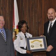
(Orlando, FL November 8, 2010) At a ceremony honoring those citizens who provided assistance to the victims and the investigative efforts of the Orlando Police Department in the aftermath of the Gateway Plaza workplace shooting, Orlando Chief of Police Val Deming presented Leica Geosystems employee Frank J. Hahnel, III with OPD’s Good Citizen Award for his on-scene assistance in documenting the homicide scene using Leica’s ScanStation C10 3D laser scanning technology.  Hahnel is an Orlando resident and is Leica Geosystems’ Accident Investigation Account Manager for North America.

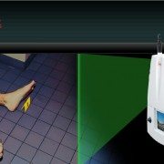
It was on November 6th, 2009 that Jason Rodriquez opened fire on former colleagues at the engineering firm he had been let go from killing one and injuring five.  Hours later Orlando Police tracked Rodriquez to his mother’s home where he peacefully surrendered.  The crime scene left behind was a large and daunting one encompassing most of the eighth floor of an office building where Rodriguez had stalked the hallways shooting his victims.  Shortly after securing the crime scene the OPD reached out to Hahnel who had only recently provided a demonstration to the agency on the capabilities of the ScanStation C10.

The ScanStation C10 is an eye-safe and easy-to-use portable 3D laser scanner that can both panoramically photograph a scene and then capture over 3.5 million survey quality measurements in less than two minutes.  The technology is used by law enforcement agencies all over the world for crime scene investigation, vulnerability and threat assessments, post-blast investigation, police action inquiries, accident investigations and more.  Hahnel responded to the call-out and systematically scanned the crime scene from 45 different perspectives to document the scene in 3D.

“The ScanStation cut the time required to do our work in half by eliminating the need to manually measure the scene” said Karen Livengood an OPD Crime Scene Investigator.  “Additionally, the data from the ScanStation lets you virtually walk through the crime scene in 3D, which makes for a clearer presentation to the jury in court” she added.

Following the award presentation by Chief Deming and Orlando Mayor Buddy Dyer, Hahnel expressed his sympathy for the victims and his appreciation for being recognized.  “Helping with the investigation was a life-changing event for me as I had never seen the results of such a violent crime.  I am grateful to have been able to help the police in the community in which I live”.

Leica Geosystems – when it has to be right

With close to 200 years of pioneering solutions to measure the world, Leica Geosystems products and services are trusted by professionals worldwide to help them capture, analyze, and present spatial information. Leica Geosystems is best known for its broad array of products that capture accurately, model quickly, analyze easily, and visualize and present spatial information.
Those who use Leica Geosystems products every day trust them for their dependability, the value they deliver, and the superior customer support. Based in Heerbrugg, Switzerland, Leica Geosystems is a global company with tens of thousands of customers supported by more than 3,500 employees in 28 countries and hundreds of partners located in more than 120 countries around the world. Leica Geosystems is part of the Hexagon Group, Sweden.

To view this release on the web please click here: http://www.leica-geosystems.us/forensic/press_19.html

For further information regarding the use of HDS for Accident Investigation contact:

Frank J. Hahnel, III
Accident Investigation Account Manager
Leica Geosystems Inc.
407.421.0873 phone
frank.hahnel@lgshds.com
www.lgshds.com
www.leica-geosystems.us/forensic

https://scanable.com/wp-content/uploads/2010/11/Demings_Dyer_Hahnel.jpg 713 1074 Travis Reinke https://scanable.com/wp-content/uploads/2025/01/SCANable_logo_emblemSimple-180x180.png Travis Reinke2010-11-08 12:35:572015-05-26 18:51:14Orlando Police Department Awards Leica Geosystems Employee for Assistance with Police Investigation of Workplace Shooting
leica law enforcement

Leica Geosystems launches a dedicated forensics program for law enforcement

November 3, 2010/0 Comments/in 3D Laser Scanning, Featured, Forensic, In the News/by Travis Reinke

Leica Geosystems launches a dedicated forensics program for law enforcement at this year’s worldwide 3D laser scanning conference.

As part of its eighth annual Worldwide User Conference devoted to 3D laser scanning in San  Ramon, California, USA (near San Francisco), Leica Geosystems successfully launched a program devoted specifically to the law enforcement and public safety community.  The event drew law enforcement agencies and forensic professionals from around the United States and the world over a four day period October 24-27, 2010.

Of special interest was the seven-hour “live fire” shooting reconstruction workshop titled “3D Laser Scanning of Shooting Scenes and Trajectories” taught by Mike Haag of the Albuquerque Police Department’s Major Crime Scene Team.   Mr. Haag has used the Leica ScanStation on dozens of cases for shooting reconstruction and he is a Distinguished Member of the Association of Firearms and Tool Mark Examiners.   Over 30 law enforcement professionals attended this class on a very rainy and wet Sunday at the Contra Costa County Sheriff’s Department who provided their facility.  The weather didn’t inhibit the operation of the Leica ScanStation C10 or the enthusiasm of the class which learned the fundamentals and best practices of shooting incident reconstruction and trajectory measurement using 3D laser scanning.

The Leica Geosystems ScanStation C10 is an easy-to-use, compact and portable 3D laser scanner that measure 3.5 million points at a scene in less than two minutes in any lighting conditions.  The system does not require any special eye protection when used, is robust and captures the leveled survey-quality data required for accurate crime scene reconstruction and analysis.

In recent years  many public safety agencies across a broad spectrum of law enforcement—County Sheriff’s departments, metropolitan police agencies and state investigative agencies—have acquired Leica ScanStations and now deploy them regularly for a wide range of tasks, including crime scene investigation,  officer involved shootings and threat assessments of buildings and other infrastructure.  Increasingly, criminal prosecutors are relying on compelling images and animations created with the system to present evidence to juries and to effectively counter the so-called “CSI effect.”

Dr. John DeHaan, of California-based Fire-Ex Forensics, Inc. an internationally recognized expert in his field and the author of Kirk’s Fire Investigation was the first speaker in the general session with a presentation titled “Documenting Fire and Explosion Scenes with Leica ScanStation Technology.” After guiding the audience through multiple cases including a home destroyed by a gas leak and an ambulance (VBIED) rigged with an explosive device as a test exercise Dr. DeHaan itemized 11 significant benefits and advantages of Leica’s ScanStation technology over other methods.

“Based on the recent, extremely rapid uptake of HDS for forensics and homeland security applications,” explained Tony Grissim, Leica Geosystems Public Safety and Forensic Accounts Manager, “the launch of a dedicated law enforcement track at this year’s conference demonstrates how seriously Leica Geosystems is committed to serving the needs of the law enforcement community.”  Grissim added that portions of the program were recorded and will be available on Leica’s forensic web site at www.leica-geosystems.com/us/forensic

Leica Geosystems—when it has to be right.

With close to 200 years of pioneering solutions to measure the world, Leica Geosystems is trusted by professionals worldwide to help them capture, analyze and present spatial information. The company is best known for its broad array of products that accurately capture, model quickly, analyze easily, visualize and present spatial information. Based in Heerbrugg, Switzerland, Leica Geosystems is a global company with tens of thousands of customers supported by more than 3,500 employees in 28 countries and hundreds of partners located in more than 120 countries. Leica Geosystems is part of the Hexagon Group, Sweden.

To view this release on the web please click here

http://www.leica-geosystems.us/forensic/press_18.html

For further information regarding the use of HDS for Accident Investigation contact:

Frank J. Hahnel, III
Accident Investigation Account Manager
Leica Geosystems Inc.
407.421.0873 phone
frank.hahnel@lgshds.com
www.lgshds.com
www.leica-geosystems.us/forensic

https://scanable.com/wp-content/uploads/2010/11/leicaforensics.jpg 446 999 Travis Reinke https://scanable.com/wp-content/uploads/2025/01/SCANable_logo_emblemSimple-180x180.png Travis Reinke2010-11-03 12:43:102015-05-26 18:53:20Leica Geosystems launches a dedicated forensics program for law enforcement

District Attorney lauds use of Leica Geosystems 3D laser scan data as demonstrative forensic evidence in homicide trial

September 3, 2009/0 Comments/in Forensic, In the News/by Travis Reinke

(Norcross, Ga., 03 September 2009)  District Attorney Joe Mulholland of the South Georgia Judicial Circuit added yet another legal case reference to the growing number of U.S. court cases in which Leica Geosystems 3D laser scan data has been admitted into evidence when he successfully proffered and tendered to the jury a visually compelling Leica TruView.

During the murder trial of Antonio Jerome Greenlee in Decatur County Superior Court, witness and crime scene investigator, Andy Forte of the Thomas County Sheriff’s Department, used Leica TruView to virtually place the jury at the crime scene and to show them how the homicide could have occurred.  The case stems from the homicide of 21-year-old Ebony Clarke of Bainbridge, GA, who was shot and killed on August 12th, 2008, during a street altercation between two men.

Leica TruView is a free, web-enabled panoramic point cloud viewer that allows users to view, pan, zoom, measure and markup the incredibly rich point cloud captured by the Leica ScanStation 3D laser scanner.  The Leica ScanStation allows investigators to first photograph and then make millions of measurements of a crime scene in just a few minutes thus “freezing the scene in time” forever.  A Leica TruView data set can then be generated in minutes after scanning for briefings or analysis or as in this case as a jury exhibit.

“The jury really, really liked it and we had jurors comment afterwards about how effective it was” said District Attorney Mulholland.  “We not only used the TruView to support Andy’s testimony, but the judge then allowed Andy to show it again during my direct examination of other witnesses as I asked them questions about where they were standing or where the shooter was.  TruView is basically a high-tech picture.  It is not testimony.  It is offered as an exhibit and demonstrative evidence.  This seemed to play well with the judge.  The Defense did not object and I think that they thought the same thing.”

Mulholland went on to say that after the trial the judge called him to the bench and commented on how effective the use of the Leica TruView was and encouraged him to use it again.  “We certainly plan on doing so.  The scanning software was absolutely fantastic” said the D.A. The judge also contacted Thomas County Sheriff R. Carlton Powell to thank him for his agency’s assistance with the case and to compliment him on the professional nature of the exhibits generated by his investigators.   Sheriff Powell was instrumental in bringing ScanStation technology to Georgia law enforcement and has made it available to the Georgia Bureau of Investigation and other agencies as a courtesy.

“The Leica ScanStation has been the choice of police and sheriff’s departments, state patrols, crime laboratories, prosecutor’s offices, coroner and medical examiners and tribal justice agencies” said Tony Grissim the Public Safety and Forensic Account Manager for Leica Geosystems.   “The high volume of traffic we are seeing on our web site at www.leica-geosystems.us/forensic is an indicator to us that word is really getting around within the law enforcement community.”
Leica Geosystems – when it has to be right

With close to 200 years of pioneering solutions to measure the world, Leica Geosystems products and services are trusted by professionals worldwide to help them capture, analyze, and present spatial information. Leica Geosystems is best known for its broad array of products that capture accurately, model quickly, analyze easily, and visualize and present spatial information.

Those who use Leica Geosystems products every day trust them for their dependability, the value they deliver, and the superior customer support. Based in Heerbrugg, Switzerland, Leica Geosystems is a global company with tens of thousands of customers supported by more than 3’500 employees in 28 countries and hundreds of partners located in more than 120 countries around the world. Leica Geosystems is part of the Hexagon Group, Sweden.

For further information please contact:

Leica Geosystems Inc.
Andre Ribeiro
Director of Marketing
Atlanta, GA 30092
Phone:   +1 (770) 326-9557
Fax:         +1 (770) 447-0710
Andre.ribeiro@leicaus.com
www.leica-geosystems.us/forensic

https://scanable.com/wp-content/uploads/2025/01/SCANable_logo_emblemSimple-180x180.png 0 0 Travis Reinke https://scanable.com/wp-content/uploads/2025/01/SCANable_logo_emblemSimple-180x180.png Travis Reinke2009-09-03 15:31:292009-09-03 15:31:29District Attorney lauds use of Leica Geosystems 3D laser scan data as demonstrative forensic evidence in homicide trial

Pages

  • 2023 Trilith Charity Gala
  • 3D Body Scanning, LiDAR and VFX Support in Houston, Texas
  • 3D Head and Body Scanning
  • 3D Object Scanning
  • 3D Scanning & VFX Capture in Los Angeles
  • 3D Scanning & VFX Capture in Texas | SCANable
  • 3D Scanning, Drone Photogrammetry & LiDAR in Atlanta | SCANable
  • 3D Scanning, Drone Photogrammetry & LiDAR in New York City | SCANable
  • 3D VFX LiDAR Scanning and Support in New Orleans, Louisiana
  • 3D VFX Scanning and Support in Atlanta, Georgia
  • 3D VFX Scanning and Support in Los Angeles, California
  • 3D VFX Scanning and Support in New York
  • About Us
  • Architecture & Heritage
  • Artec Leo
  • Asset
  • Awards
  • Blog
  • C.A.L.V.I.N.N.™ Camera Array for Lightfields, Volumetrics, Imaging, and Neural Networks
  • Cart
  • Checkout
  • Civil/Survey
  • Clients
  • Contact
  • Drone Photogrammetry
  • FARO Focus S 150 and 350 3D Laser Scanner
  • FARO Focus3D X 330 Long Range 3D Laser Scanner
  • FARO Freestyle3D Handheld Scanner
  • Home
  • Industry News
  • Leica HDS6200
  • LiDAR Location and Environment 3D Scanning
  • Logout
  • Maquette, Statues and Fine Art 3D scanning
  • Mobile 3D Scanning
  • Mobile Photogrammetry Studios
  • MoPho 1 Service Request
  • MoPho 2 Service Request
  • MoPho 3 Service Request
  • My Account
  • New
  • News
  • Plant, Process & Marine
  • Pricing and FAQ
  • Privacy Policy
  • Purchase Affordable 3D Laser Scanners
  • Recent Productions
  • Rent the Leica RTC360
  • Request 3D Scanning Services
  • SCANable Rig Checklist
  • SCANable UAS (Unmanned Aerial Systems)
  • SCANable | COVID-19 Response
  • Security and Threat Analysis
  • Services
  • Shop
  • Surphaser 100HSX
  • Trailer Move
  • Training and Support
  • VFX 3D Vehicle Scanning For Film and Television
  • VFX is not AI
  • Virtual Reality
  • Visual Effects/CGI

Categories

  • 3D Laser Scanning
  • 3D Printing
  • Animation
  • Archaeology
  • Blog
  • Building Information Modeling (BIM)
  • Events
  • Featured
  • Forensic
  • Government
  • In the News
  • Industrial
  • Industry
  • LiDAR
  • Mobile Scanning
  • Modeling
  • New Hardware
  • New Technology
  • News
  • Photogrammetry
  • Point Cloud
  • Reviews
  • Software
  • Uncategorized
  • Virtual Reality
  • Visual Effects (VFX)

Archive

  • June 2025
  • May 2025
  • January 2025
  • December 2024
  • November 2022
  • October 2020
  • August 2020
  • July 2020
  • June 2020
  • January 2020
  • July 2017
  • May 2017
  • April 2017
  • December 2016
  • November 2016
  • October 2016
  • September 2016
  • July 2016
  • May 2016
  • March 2016
  • September 2015
  • June 2015
  • May 2015
  • March 2015
  • January 2015
  • December 2014
  • November 2014
  • August 2014
  • June 2014
  • April 2014
  • March 2014
  • February 2014
  • January 2014
  • November 2013
  • June 2013
  • March 2013
  • January 2013
  • December 2012
  • November 2012
  • September 2012
  • August 2012
  • July 2012
  • December 2010
  • November 2010
  • October 2010
  • August 2010
  • May 2010
  • April 2010
  • March 2010
  • February 2010
  • January 2010
  • December 2009
  • November 2009
  • October 2009
  • September 2009
  • August 2009
  • July 2009
  • June 2009
  • May 2009

Quick Pages

  • Home
  • News
  • Services
  • Contact
  • Privacy Policy

Recent Productions

  • Play Dirty (Prime Video)
  • Peacemaker (DC Studios)
  • Marty Supreme (A24)
  • Superman (DC Studios)
  • Happy Gilmore 2 (Netflix)

Categories

  • 3D Laser Scanning
  • 3D Printing
  • Animation
  • Archaeology
  • Blog
  • Building Information Modeling (BIM)
  • Events
  • Featured
  • Forensic
  • Government
  • In the News
  • Industrial
  • Industry
  • LiDAR
  • Mobile Scanning
  • Modeling
  • New Hardware
  • New Technology
  • News
  • Photogrammetry
  • Point Cloud
  • Reviews
  • Software
  • Uncategorized
  • Virtual Reality
  • Visual Effects (VFX)

Locations

Georgia

Los Angeles

New York

Houston

New Orleans

© Copyright 2026 - SCANable - Enfold Theme by Kriesi
  • Link to Facebook
  • Link to X
  • Link to LinkedIn
  • Link to Youtube
  • Link to Rss this site
  • Link to Instagram
Scroll to top Scroll to top Scroll to top