Leica_CloudWorx_for_AutoCAD

Leica Geosystems announces updates for its point cloud software applications

Leica Geosystems announces a major set of updates for its point cloud software applications within its flagship Leica Cyclone and Leica CloudWorx families. These updates save a significant time in the office per day and make it more convenient to work with rich, as-built point cloud data. This is the company’s largest set of point cloud software releases to date.

“What we’re seeing in the market is that our customers are using laser scanning in an increasing variety of scenarios and under more demanding circumstances, so they need more options for working with point cloud data and they need to do their work even faster,” states Chris Thewalt, VP of Scanning Software.  “Overall, we continue to see strong growth of 3D laser scanning/High-Definition Surveying (HDS) with a corresponding expansion and diversification of our user community’s needs. In response, we’ve been investing heavily in a number of our standalone Cyclone and our plug-in CloudWorx point cloud software applications. This large set of releases reflects that ongoing investment.”

Leica Cyclone and Leica CloudWorx families

• More flexible licensing lets users easily move licenses between the field and office and on-or-off a network.
• Users on customer support can implement license upgrades on their own at any time
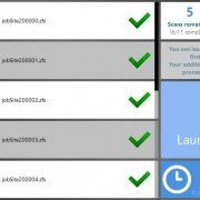
• Rentals are now available for as short as one week for most products; discounts are available for extended rental periods

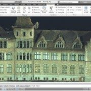
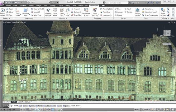
Leica CloudWorx for AutoCAD 5.0

• Plug-in for AutoCAD saves hours in the office for working with 3D point clouds in AutoCAD for both experienced users and users new to working in 3D
• Easier X,Y,Z coordinate system setup and faster navigation to desired views; faster creation of 2D drawings; faster ground surface and TIN creation; and, faster selection of high, low and ground points

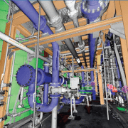
Leica CloudWorx for 3ds Max 2.0

• New Leica CloudWorx plug-in family member (replaces Leica CloudWorx-VR)
• Eliminates prior need to export from Cyclone and import to Leica CloudWorx-VR; users now enjoy direct data access to Cyclone files
• Adds rich set of standard CloudWorx plug-in tools for working more efficiently with point clouds in 3ds Max

Leica CloudWorx for PDMS 1.3

• Plug-in for PDMS adds valuable option of importing plant models from PDMS directly into Leica Cyclone and exporting models created from point clouds in Cyclone directly into PDMS
• Avoids prior need to import/export models into/from PDMS and Cyclone via AutoCAD or MicroStation
• Supports direct import of PDMS models into popular Leica TruView software

Leica_CloudWorx_for_AutoCAD

LFM Server

LFM Server 4.2 – Introducing Key New Features

As 3D laser scanning has become easier and more affordable it has become the technology of choice for ‘as-is’ data capture. LFM Server™ enables users to maximize the value of the rich information that laser scanning generates.

LFM Server is the most advanced solution available for accessing pre-registered laser scan data and working with it directly in 3D CAD systems. It is simple to use and offers unrivalled performance and functionality.

There are many different 3D laser scanners and 3D CAD systems in use today. LFM Server has been developed to provide users with maximum freedom of choice of both scanning and design systems. It can read unstructured data from various scanner types; not only terrestrial laser scanners but also hand-held, mobile or aerial scanners.

Designed to work with data from even the highest-resolution scanner, LFM Server enables users to work with datasets of unlimited size and exploit photorealistic, 360° BubbleViews™.

Business Benefits

  • Open on the input
    LFM Server can read a wide variety of 3D data capture formats
  • Open on the output
    LFM Server interfaces seamlessly with all leading 3D CAD systems
  • Unlimited Datasets
    InfiniteCore™ technology enables project datasets of unlimited size to be readily created and accessed
  • Increased Productivity
    The intuitive 360° BubbleView makes it easy to verify clashes, review laser scan data, or simply become familiar with the site
  • Clash-free Design
    Accurate, detailed ‘as-is’ information minimizes the business risks of revamp projects
  • Business Flexibility
    Import scans from a wide variety of scanner types and data formats into a single dataset

For more information about LFM Server 4.2’s great new features, contact us or read more here.

Autodesk ReCap: Making Reality Capture Easy and Affordable

Autodesk Aims to Streamline Use of Point Cloud Data

A key addition to the complete 2014 portfolio of Suites is Autodesk® ReCap™ product, a family of powerful and easy-to-use software and services on the desktop and in the cloud to create intelligent 3D data from captured photos and laser scans in a streamlined workflow.  Autodesk ReCap is the first industry solution to bring together laser scanning and photogrammetry into one streamlined process. In addition, no other solution on the market provides the visualization quality and scalability to handle extremely large data sets.

The Autodesk ReCap product line comprises two main offerings – Autodesk ReCap Studio and Autodesk ReCap Photo. Autodesk ReCap Studio makes it easy to clean, organize and visualize massive datasets captured from reality. Autodesk ReCap Photo helps users create high-resolution textured 3D models from photos using the power of cloud computing. Rather than beginning with a blank screen, Autodesk ReCap now enables any designer, architect or engineer to add, modify, validate and document their design process in context from existing environments.

For example, a civil engineer can bypass an existing bridge or expand the road underneath digitally and test feasibility. At construction phase, builders can run clash detection to understand if utilities will be in the way. Urban planners can get answers to specific design questions about large areas, such as how much building roof surface is covered by shadow or vegetation.

ReCap Studio is a data preparation environment that runs on the desktop.  Users can import captured data directly into Autodesk design solutions, such as AutoCAD®, Autodesk® Revit®, Autodesk Inventor®, etc., to conduct QA and verification of data. The data can come from non-intelligent, black and white sparse point clouds to intelligent, visually high appealing content. ReCap Studio will ship in Autodesk product and suite installers or be available for free on the Autodesk Exchange Apps store.

ReCap Studio 2

ReCap Photo is an Autodesk 360 service designed to create high resolution 3D data from photos to enable users to visualize and share 3D data. By leveraging the power of the cloud to process and store massive data files, users can upload images on Autodesk 360 and instantly create a 3D mesh model. ReCap Photo is available with Standard Suites entitlement and higher.

ReCap Photo 2

Key features of Autodesk ReCap include:

  • Visualize and edit massive datasets:  On the desktop, ReCap users can view and edit billions of points to prepare them for use in Autodesk portfolio products to enable realistic in context design work
  • Professional-Grade Photo to 3D Features: ReCap unlocks the power of ubiquitous cameras to capture high-quality 3D models, bringing reality capture within reach of anyone with a camera.  ReCap supports objects of any size and range, full resolution for high-density meshes, survey points and multiple file exports.
  • Photo and Laser: ReCap incorporates the best of both photo and laser data capture so that customers can use photos to fill in holes or augment laser scan data. Users can both increase photos scene accuracy with laser points and add photo-realistic detail to laser scans. Create point clouds from photos, align scans and photos and convert professional grade photo to 3D models.

Autodesk continues to invest in developing sophisticated, easy-to-use reality capture technologies. The company has made several key acquisitions including Alice Labs and Allpoint Systems as well as applied its own research and development resources to accelerate the mainstream adoption of these technologies. As customers are looking for ways to easily and accurately capture the world around them, Autodesk ReCap streamlines Reality Capture workflows, making working with Reality Capture data easyquick and cost effective.

Autodesk is the only company who has combined laser scanning data and photogrammetry into one product family to address and streamline the entire workflow.  Whereas traditional point clouds appear as dots, Autodesk technology can now visualize truly massive point clouds as realistic surfaces. Unique to Autodesk is that users can interact with these huge data sets doing CAD-like operations such as selection, tagging, moving, measuring, clash detection, and object extraction, all with native points. Laser scanning and photogrammetry are historically very expensive and data intensive. Autodesk’s goal is to democratize the process of reality capture so that anyone can capture the world around them to create high quality 3D models.

ILM Hulk Avengers Mark Ruffalo as the Hulk in "The Avengers," courtesy of Marvel Films.

How ILM Used Laser Scanning to Give Life to the Hulk in Marvel’s The Avengers

Industrial Light & Magic, a division of Lucasfilm Ltd. and now owned by The Walt Disney Company, forever changed the way movies are made and how we as the viewer experience them. The movie-making geniuses have continually raised the bar in computer-generated imagery (CGI) and visual effects (VFX) year after year since the company’s founding by George Lucas in May of 1975. Released today, ILM takes us behind the scenes to show us how they used laser scanning and other tools to transform Mark Ruffalo into the lovable Hulk character that almost stole the show in Marvel’s third highest-grossing film of all time, The Avengers.

Check out more ILM movie magic on their YouTube channel.